1pm Advisory: Pressure is Down. Francine Looking More Organized.
Quick update on the latest advisory from the NHC.
Stats:
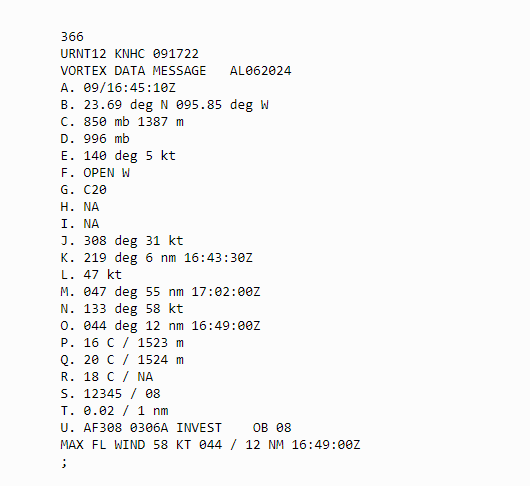
LOCATION…23.7N 95.8W
ABOUT 180 MI…285 KM SSE OF MOUTH OF THE RIO GRANDE
ABOUT 450 MI…720 KM SSW OF CAMERON LOUISIANA
MAXIMUM SUSTAINED WINDS…60 MPH…95 KM/H
PRESENT MOVEMENT…NNW OR 340 DEGREES AT 5 MPH…7 KM/H
MINIMUM CENTRAL PRESSURE…996 MB…29.41 INCHES
The pressure has dropped 6 mb since the last advisory. The maximum winds are up to 60 mph. Here is the dropsonde data that came in right before the advisory.
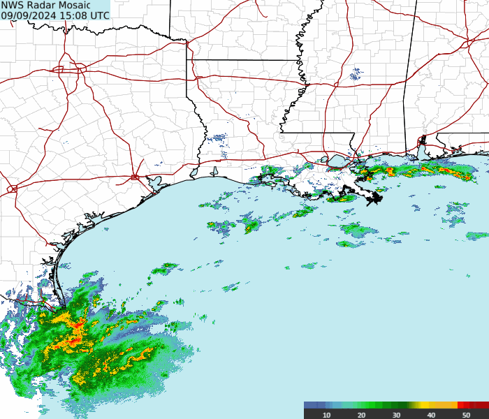
Francine is moving into an environment highly conducive to strengthening. It is very interesting to watch the latest radar out of Brownsville. It would appear you can see the center (eye-feature) of Francine starting to show up. Radar courtesy Brian McNoldy, Univ. of Miami, Rosenstiel School.
All areas under advisories along the Texas/Louisiana Coast need to prepare for a hurricane (and a possible strong one) and need to prepare for that now.
SUMMARY OF WATCHES AND WARNINGS IN EFFECT:
A Storm Surge Watch is in effect for…
* High Island Texas to the Mississippi/Alabama Border
* Vermilion Bay
* Lake Maurepas
* Lake Pontchartrain
A Hurricane Watch is in effect for…
* The Louisiana coast from Cameron eastward to Grand Isle
A Tropical Storm Watch is in effect for…
* Barra del Tordo to the Mouth of the Rio Grande
* Mouth of the Rio Grande to Port Mansfield
* East of High Island Texas to Cameron Louisiana
* East of Grand Isle to Mouth of the Pearl River
* Lake Pontchartrain
* Lake Maurepas
About the Author (Author Profile)
Owner of Tornado Talk. Radio broadcast meteorologist with The Storm Report. WeatherBrains Panelist. B.S. Meteorology from Penn State University.Subscribe
If you enjoyed this article, subscribe to receive more just like it.


