Noon Update from the NHC: Plus Some Tide Reports
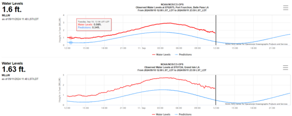
Current storm surge levels along the Louisiana coast:
Southwest Pass (Mouth of the Mississippi): 1.8′
Grand Isle 1.13′
Port Fourchon 1.12′
Berwick 1.28′
Eugene Island 2.12′
Winds are still generally out of the E or ENE at all these stations, so onshore flow is not engaged yet.
It looks like most these Louisiana coastal locations will be in low tide status around teh time of landfall.
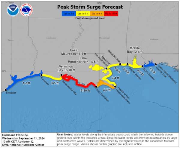
Here is the projected max surge from the NHC:
Hurricane Francine Tropical Cyclone Update
NWS National Hurricane Center Miami FL AL062024
1200 PM CDT Wed Sep 11 2024
…CONDITIONS BEGINNING TO DETERIORATE IN SOUTHERN LOUISIANA…
…1200 PM CDT POSITION UPDATE…
Rainbands of Francine continue to move onshore and spread
inland into southern Louisiana. Tropical-storm-force winds are just
offshore, and conditions will continue to deteriorate throughout the
afternoon. Ensure you are in a safe location before the onset of
these strong winds or possible flooding, and have multiple ways to
receive warnings.
An oil platform north of the center recently reported sustained
winds of 85 mph (137 km/h) and a gust of 100 mph (161 km/h)
at an elevation of 98 ft (30 m).
SUMMARY OF 1200 PM CDT…1700 UTC…INFORMATION
———————————————–
LOCATION…28.3N 92.3W
ABOUT 120 MI…190 KM SW OF MORGAN CITY LOUISIANA
ABOUT 180 MI…285 KM SW OF NEW ORLEANS LOUISIANA
MAXIMUM SUSTAINED WINDS…90 MPH…150 KM/H
PRESENT MOVEMENT…NE OR 40 DEGREES AT 13 MPH…20 KM/H
MINIMUM CENTRAL PRESSURE…976 MB…28.82 INCHES
$$
Forecaster Kelly


