Hurricane Francine Update: Life-Threatening Conditions in Southern Louisiana
As of 7:00 PM CDT, Hurricane Francine is continuing to unleash dangerous weather conditions across southern Louisiana. The National Hurricane Center has issued warnings of life-threatening storm surge, hurricane-force winds, and heavy rains affecting coastal areas, particularly near Morgan City and New Orleans.
Current Status of Hurricane Francine
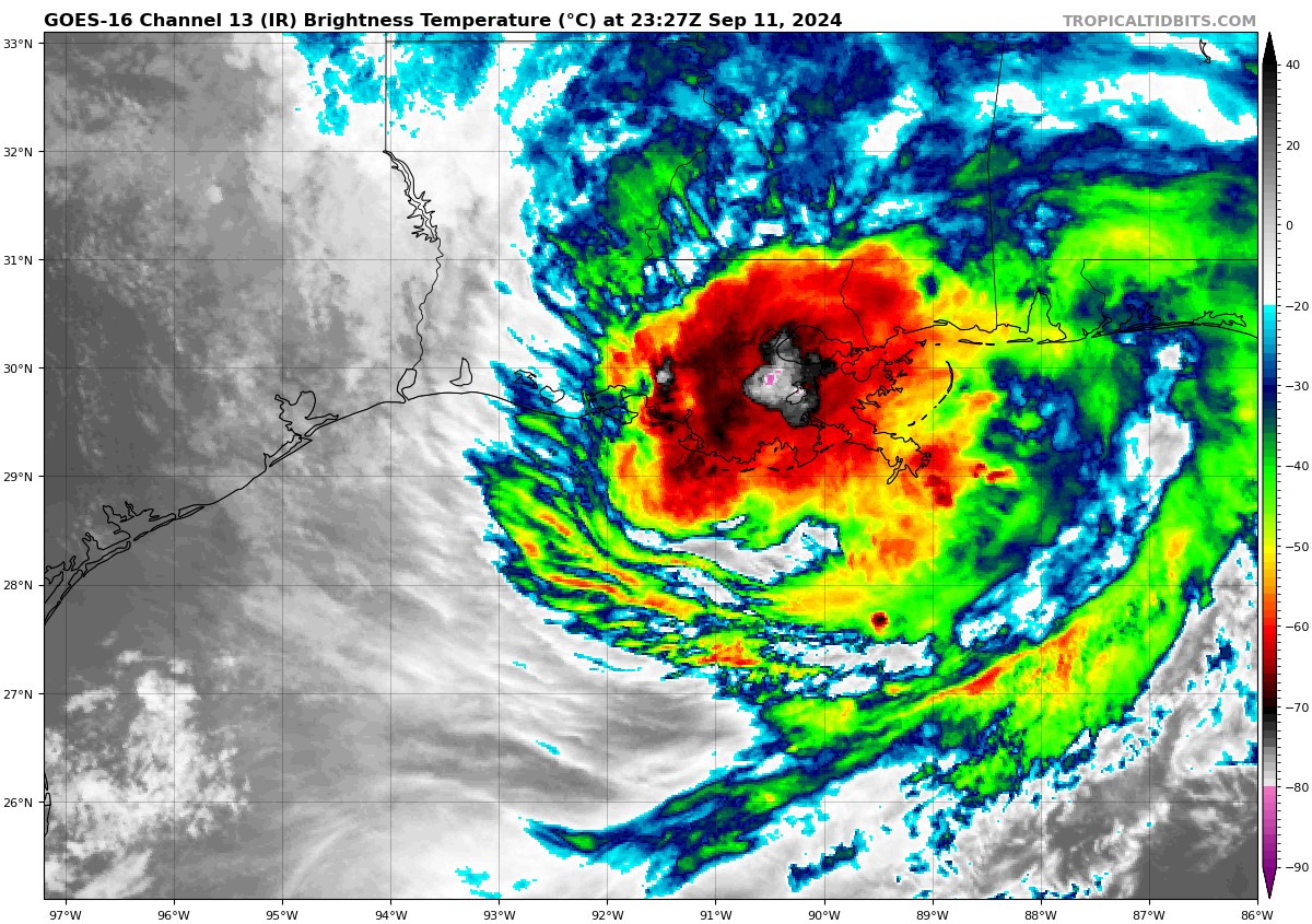
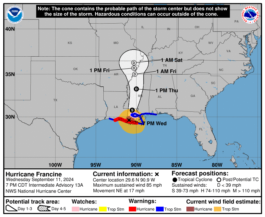
Hurricane Francine is located just 20 miles east-southeast of Morgan City, Louisiana, and about 55 miles west-southwest of New Orleans. The storm is moving northeast at a speed of 17 mph, bringing sustained winds of up to 85 mph with higher gusts. The storm’s center is expected to pass through southeastern Louisiana tonight and move over Mississippi by Thursday.
The hurricane’s central pressure is currently 978 MB, signaling a weakening trend. However, it is still capable of causing serious damage. Francine is expected to lose strength and transition into a post-tropical system by Thursday night or Friday.
Areas Under Watch and Warning
Several warnings are in place due to the threat of storm surge, hurricane-force winds, and flooding:
Storm Surge Warning: Areas from the Vermilion/Cameron Parish Line in Louisiana to the Mississippi/Alabama border are at risk. Vermilion Bay, Lake Maurepas, and Lake Pontchartrain are also under this warning.
Hurricane Warning: The Louisiana coast, from the Vermilion/Cameron Line eastward to Grand Isle, is under a hurricane warning, meaning hurricane conditions are expected shortly.
Tropical Storm Warning: Coastal areas stretching from Cameron, Louisiana, to the Alabama/Florida border are under a tropical storm warning. This includes Lake Maurepas, Lake Pontchartrain, and metropolitan New Orleans, where tropical storm conditions are anticipated.
These warnings emphasize the immediate dangers posed by rising waters, high winds, and flash flooding. Residents in these areas are strongly urged to follow evacuation orders and take precautions to safeguard their lives and property.
Hazards Expected
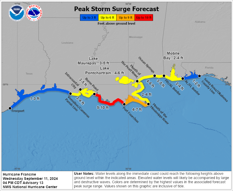
Storm Surge: Storm surge is the greatest threat to coastal communities, with waters expected to rise between 5 to 10 feet from Burns Point to Port Fourchon, Louisiana. The Mississippi Gulf Coast could see waters surge by up to 6 feet. Dangerous waves will likely accompany this surge, increasing the risk of severe flooding.
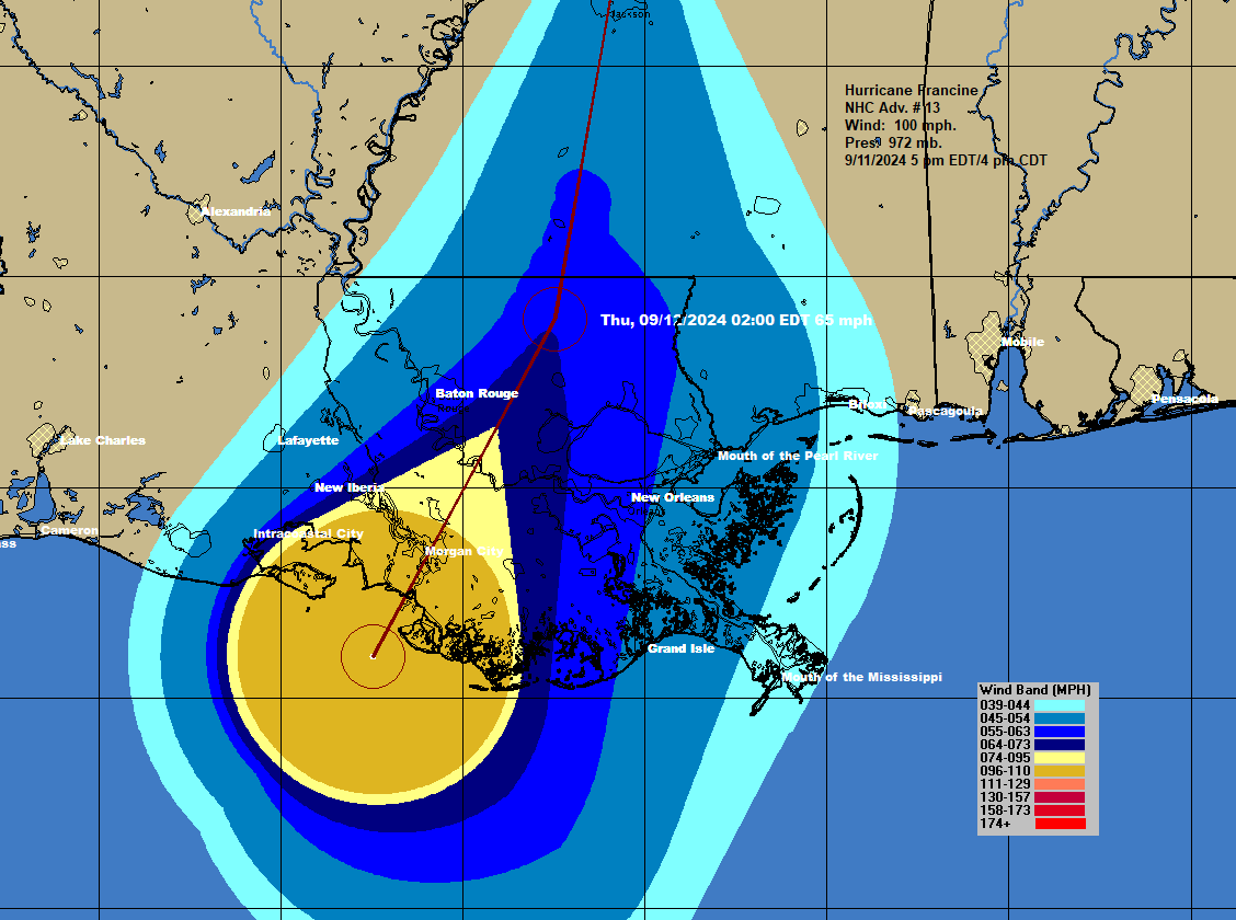
Wind: Hurricane-force winds extend up to 40 miles from the storm’s center, while tropical-storm-force winds reach up to 140 miles outward. These strong winds can lead to extensive power outages and structural damage.
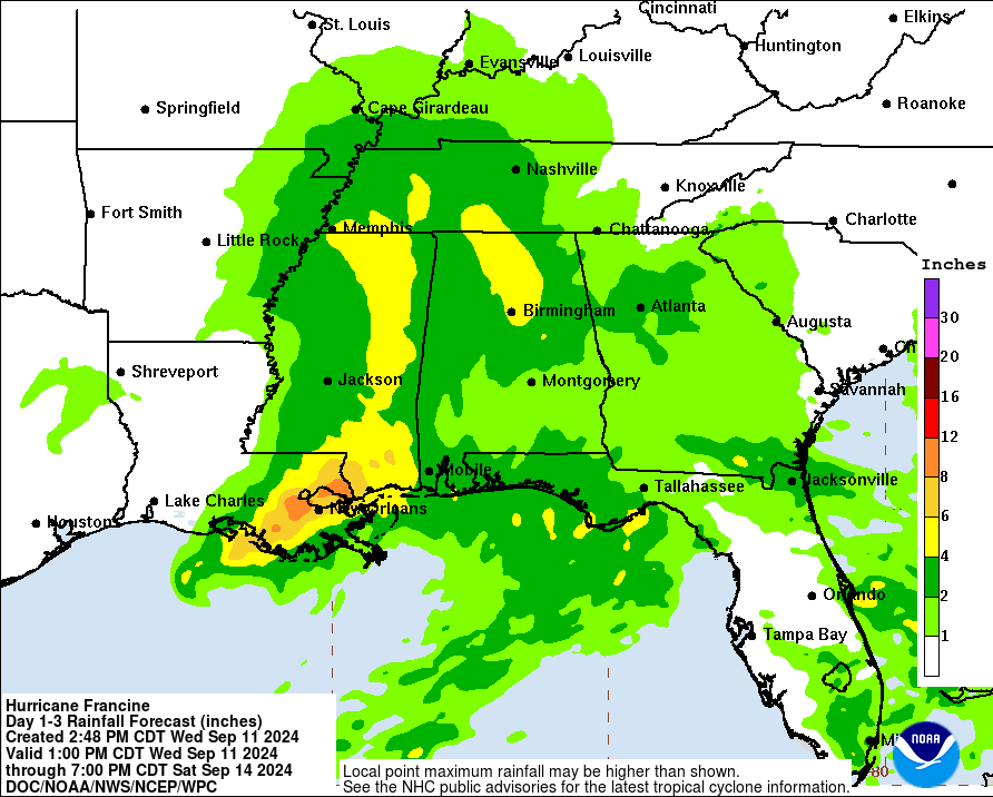
Rainfall: Heavy rainfall will affect southeastern Louisiana, Mississippi, and parts of southern Alabama and the Florida Panhandle, with total accumulations between 4 and 8 inches. Some localized areas could see as much as 12 inches of rain, which could lead to flash flooding in urban areas and along rivers.
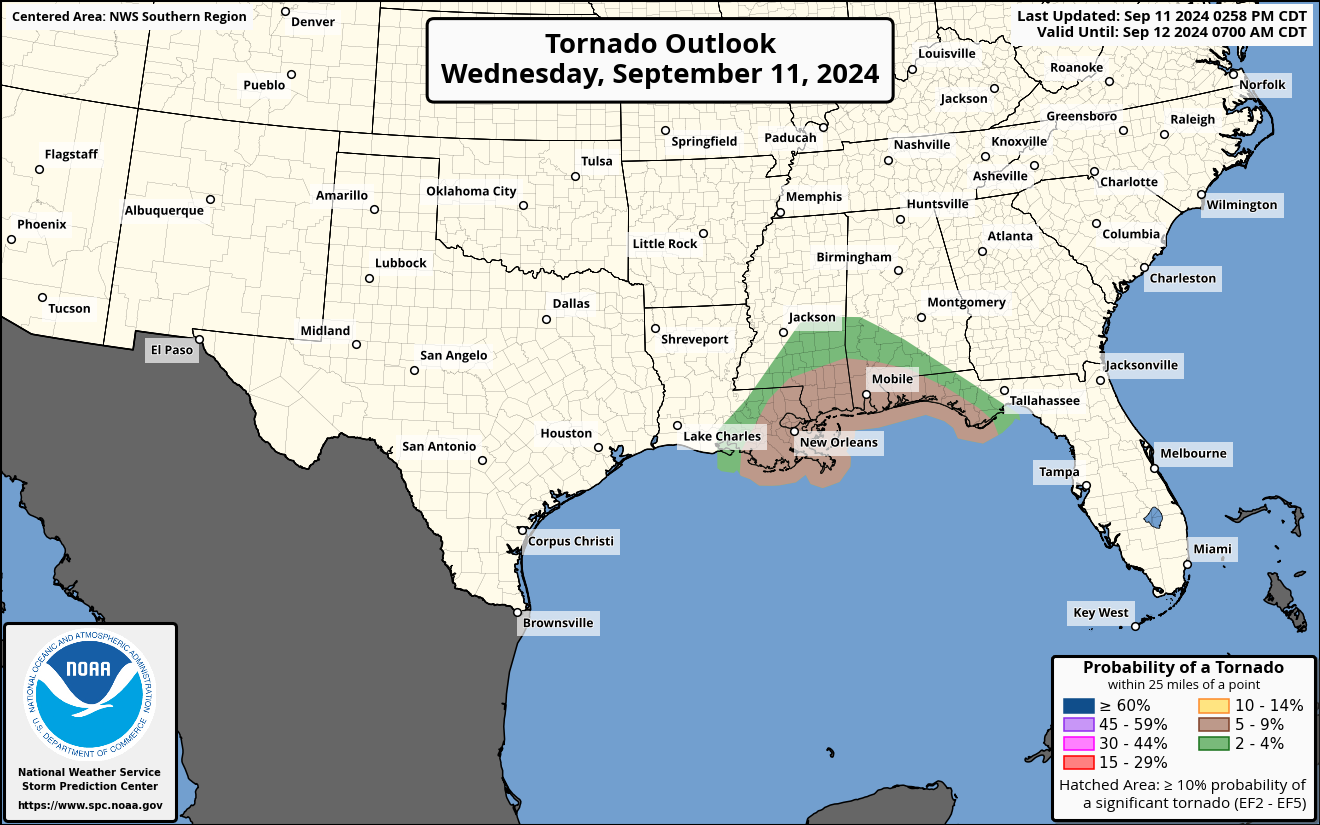
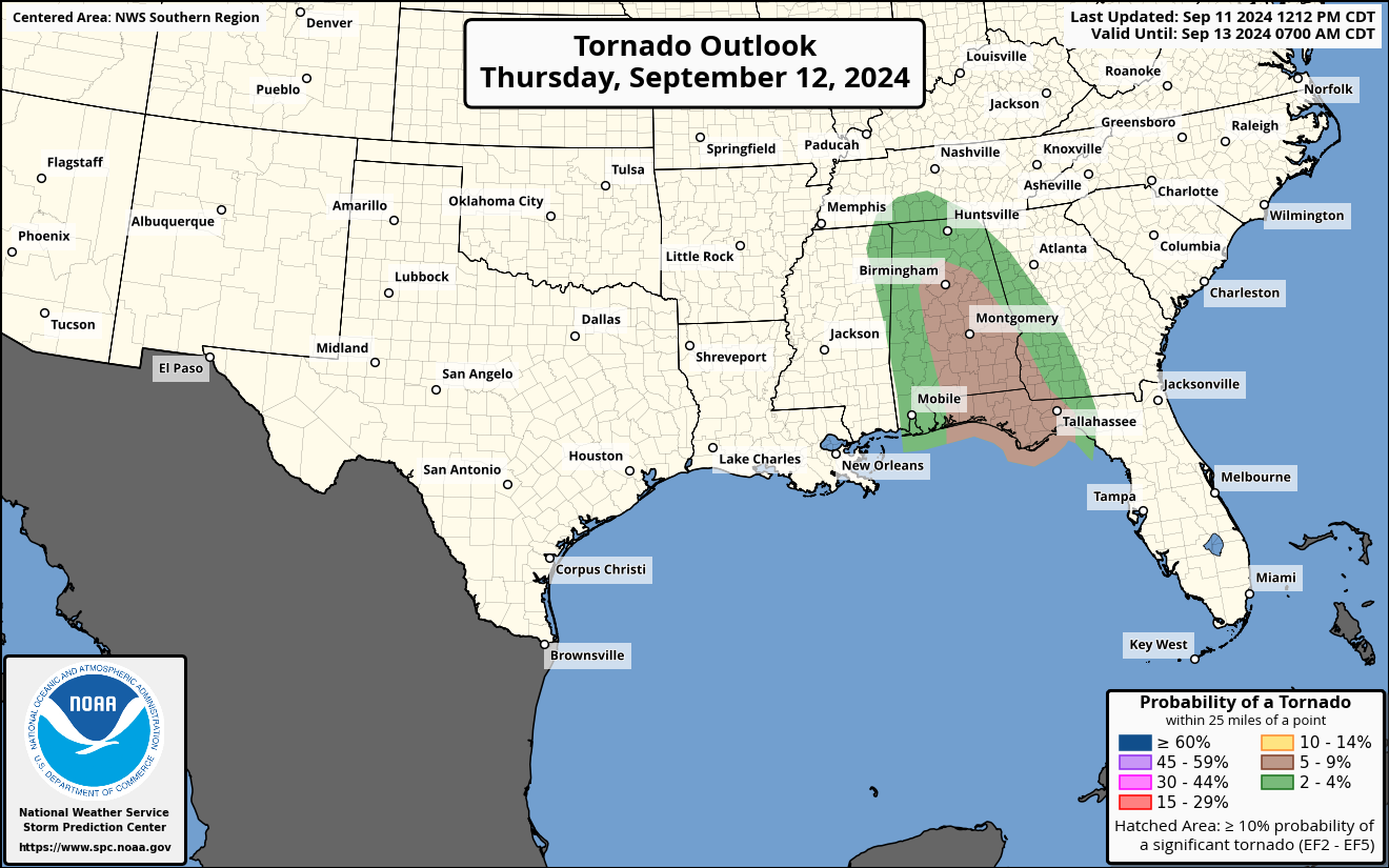
Tornadoes: As the hurricane moves inland, there is a risk of tornadoes across parts of southeast Louisiana, southern Mississippi, southern Alabama, and the Florida Panhandle through the night. By Thursday, this risk will shift into Alabama, southwest Georgia, and the Florida Panhandle.
Surf and Rip Currents: Dangerous swells generated by Hurricane Francine are impacting the northern Gulf Coast, increasing the risk of life-threatening surf and rip currents.
Category: ALL POSTS, Severe Weather, Tropical
About the Author (Author Profile)
Scott Martin is an operational meteorologist, professional graphic artist, musician, husband, and father. Not only is Scott a member of the National Weather Association, but he is also the Central Alabama Chapter of the NWA president. Scott is also the co-founder of Racecast Weather, which provides forecasts for many racing series across the USA. He also supplies forecasts for the BassMaster Elite Series events including the BassMaster Classic.Subscribe
If you enjoyed this article, subscribe to receive more just like it.


