While Eyes Are On Francine, We Can’t Forget About the Other Disturbances
Tropical Weather Update: Hurricane Francine and Other Developing Systems
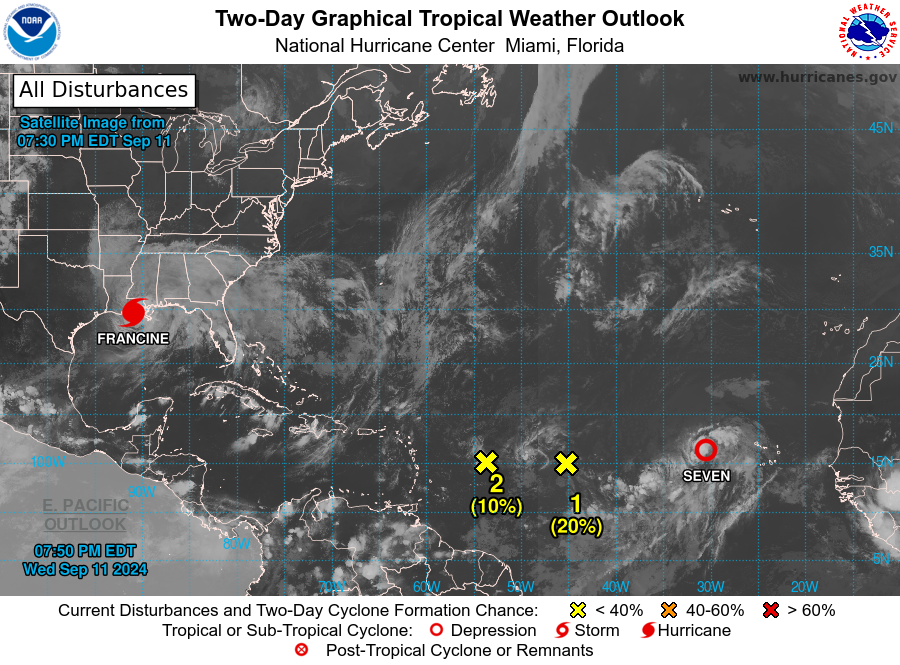
As of 7:00 PM CDT, the National Hurricane Center continues to monitor several systems in the North Atlantic, Caribbean Sea, and the Gulf of Mexico. Here’s the latest on active and potential tropical weather activity.
Current Active Systems
Hurricane Francine
Francine is currently affecting southern Louisiana, bringing life-threatening storm surge, hurricane-force winds, and heavy rain to the region. For those in the affected areas, it is crucial to follow all advisories and evacuation orders from local officials.
Tropical Depression Seven
Located over the eastern Atlantic Ocean, Tropical Depression Seven is also being tracked by the National Hurricane Center. While it is not an immediate threat to land, further updates will provide more information on its trajectory and development.
Monitoring Other Areas of Disturbance
Central Tropical Atlantic (AL92)
An area of low pressure in the central tropical Atlantic is producing disorganized showers and thunderstorms. While environmental conditions are only marginally favorable, there is a slight chance of development as it moves westward at 5 to 10 mph. However, stronger upper-level winds expected on Friday may inhibit further development.
- Chance of formation in 48 hours: Low, 20%
- Chance of formation in 7 days: Low, 20%
East of the Leeward Islands (AL94)
A small area of low pressure located several hundred miles east of the Leeward Islands is showing limited storm activity. Dry air surrounding the system is expected to hinder any major development over the next couple of days. Additionally, environmental conditions will become less favorable by the weekend as it moves west-northwestward.
- Chance of formation in 48 hours: Low, 10%
- Chance of formation in 7 days: Low, 10%
Offshore the Southeastern U.S.
In a few days, a non-tropical low-pressure system may develop off the southeastern U.S. coast, forming along a lingering frontal boundary. There is a possibility for subtropical or tropical development early next week as the system drifts to the north or northwest.
- Chance of formation in 48 hours: Low, near 0%
- Chance of formation in 7 days: Low, 30%
About the Author (Author Profile)
Scott Martin is an operational meteorologist, professional graphic artist, musician, husband, and father. Not only is Scott a member of the National Weather Association, but he is also the Central Alabama Chapter of the NWA president. Scott is also the co-founder of Racecast Weather, which provides forecasts for many racing series across the USA. He also supplies forecasts for the BassMaster Elite Series events including the BassMaster Classic.Subscribe
If you enjoyed this article, subscribe to receive more just like it.


