Tornado Threat Continues For Locations Under The Northeastern Quadrant of Francine
The threat of tornadoes remains in the northeastern part of Hurricane Francine. While storm activity has been limited so far, the winds in the lower atmosphere are very strong, which could increase the chance of tornadoes later tonight.
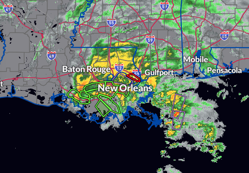
As of 7:15 PM CDT, Hurricane Francine’s center was located 55 miles southwest of New Orleans, Louisiana. In the northeastern area of the storm, strong winds in the lower atmosphere are creating conditions favorable for tornadoes. Radar is showing wind shear (winds changing direction and speed with height) between 500-600 m²/s², which is a key sign of possible tornado development.
Right now, the risk of tornadoes is being held back because the more unstable, warm air from the Gulf of Mexico hasn’t moved inland yet. Winds from the east and northeast are preventing this air from reaching the land. However, as Francine moves further inland, these winds are expected to change direction, bringing that warmer, unstable air onshore. This could lead to a greater risk of tornadoes in areas like southeastern Louisiana, southern Mississippi, and southwestern Alabama later tonight.
Some storms in Francine’s outer rain bands have already shown signs of rotation, meaning they could become tornado-producing supercells. Weather models predict that a few of these rotating storms could move inland tonight. Forecasts show that the atmosphere ahead of these storms has enough energy and wind shear to support tornado formation, with some storms having a moderate chance of becoming tornado-producing.
Category: ALL POSTS, Severe Weather, Tropical
About the Author (Author Profile)
Scott Martin is an operational meteorologist, professional graphic artist, musician, husband, and father. Not only is Scott a member of the National Weather Association, but he is also the Central Alabama Chapter of the NWA president. Scott is also the co-founder of Racecast Weather, which provides forecasts for many racing series across the USA. He also supplies forecasts for the BassMaster Elite Series events including the BassMaster Classic.Subscribe
If you enjoyed this article, subscribe to receive more just like it.


