The Arctic Oscillation and Alabama’s Cold Weather
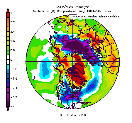
(December and January temperature departure from normal)
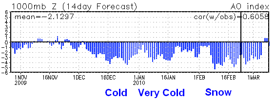
James and I have talked about the Arctic Oscillation, or AO, quite a bit this winter. It has been negative for most of Dec, Jan, and Feb, and it looks like it will stay that way for another week or two. Typically, a negative AO means cold air for the southeast United States.
The AO is defined by the average surface pressures in the Arctic, relative to normal. When the AO is negative, pressures over the Arctic are high, causing a more efficient southward flow of the cold air from the Arctic to the midlatitudes (North America, Europe, Asia). Basically, this means that intense cold air does not build up as much in the Arctic, but instead often flows southward. It keeps temperatures in the Arctic above normal, and temperatures in mid-latitudes below normal. As shown in the picture at the top, this has definitely been the case this year, with temperatures way below normal over much of the United States, Europe, and northern Asia, but above normal over Canada and Greenland.
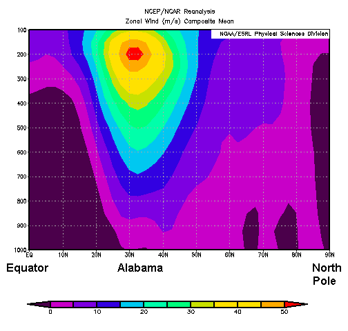
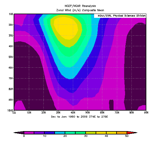
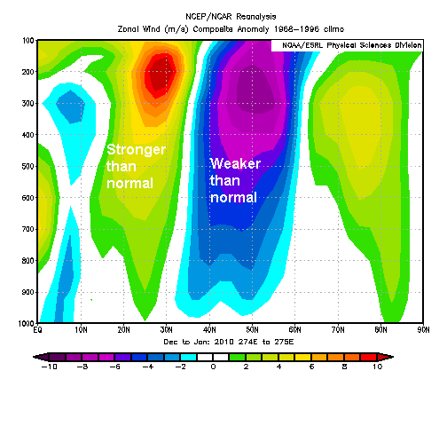
In a negative AO, there is not as much difference between the temperature in the Arctic and the temperature here as normal. Since the upper-level winds are related to the temperature difference from north-to-south, the jet stream has been weaker than normal over most of North America, and the strongest winds have been pushed farther south than normal. Yet, the southerly jet stream has been stronger than normal, also likely associated with this year’s El Nino. Check out the vertical cross-sections below along 86 degrees W. These show the atmosphere from near Guatemala to eastern Alabama to Michigan to the North Pole. The first one shows this year’s Dec through Jan jet stream winds, the second one shows the same thing averaged for 1950-2009, and the third one shows this year’s departure from normal.
Note that the actual jet near 30 North (subtropical) is stronger than normal, partially explaining our active weather pattern with so many chances for snow and rain, but the overall jet stream over most of North America has been weaker than normal.
Below is a chart of the AO for this winter, and the forecast for it to the right of line. It should stay below normal into next week, meaning more cold air (and chances for snow, as James discusses in his morning video forecast below), then there are indications the AO may finally go positive in March. That could mean milder weather. Then again, Spring is on the way, the days are longer, and it should warm up soon anyway!
If you need meteorological consultants, call Coleman and Peters LLC at (205) 568-4401, or www.colemanpetersllc.com. We help attorneys, insurance adjusters, and others who need detailed analysis of past weather events.
Category: Met 101/Weather History




Comments (8)
Trackback URL | Comments RSS Feed
Sites That Link to this Post