Flash Flood Warning Extended for Cullman, Western Morgan and Eastern Lawrence Counties / The Heavy Rain Threat To Continue For Parts of Tonight
In this update, we look at the situation in parts of North Central Alabama and look at the latest discussion from the WPC on how much longer we will be dealing with heavy rain!
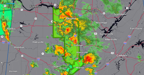
Extremely heavy rain continues to fall across the warned area. Rainfall rates of 1-3 inches in an hour still expected and this is on top of what we has already been seen. Flash flooding is being observed in the warning area. This is a very dangerous situation. Please be weather aware!
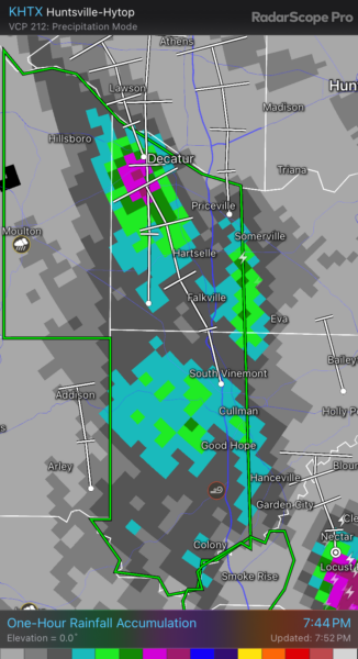
Below is the 1-hour rainfall accumulation. That area in purple near Decatur indicates about 1-1.5 inches over the past hour.
BULLETIN – EAS ACTIVATION REQUESTED
Flash Flood Warning
National Weather Service Huntsville AL
647 PM CDT Fri Sep 13 2024
The National Weather Service in Huntsville has extended the
* Flash Flood Warning for…
Cullman County in north central Alabama…
Western Morgan County in north central Alabama…
Eastern Lawrence County in northwestern Alabama…
* Until 900 PM CDT.
* At 647 PM CDT, Emergency management reported thunderstorms
producing heavy rain across Eastern Lawrence, Western Morgan, and
Western Cullman Counties in North Central Alabama. Flash flooding
was reported in the cities of Moulton and Cullman. Rainfall rates
of 1 to 3 inches per hour are expected, with additional amounts of
1 to 2 inches are possible in the warned area. Flash flooding is
ongoing or expected to begin shortly.
HAZARD…Flash flooding caused by thunderstorms.
SOURCE…Emergency management reported.
IMPACT…Flash flooding of small creeks and streams, urban
areas, highways, streets and underpasses as well as
other poor drainage and low-lying areas.
* Some locations that will experience flash flooding include…
Decatur, Cullman, Hartselle, Moulton, Priceville, Good Hope,
Trinity, Falkville, Courtland, Dodge City, Baldwin, Vinemont,
North Courtland, West Point, Hillsboro, Colony, Massey,
Battleground, Neel and Jones Chapel.
PRECAUTIONARY/PREPAREDNESS ACTIONS…
Turn around, don’t drown when encountering flooded roads. Most flood
deaths occur in vehicles.
Be especially cautious at night when it is harder to recognize the
dangers of flooding.
In hilly terrain there are hundreds of low water crossings which are
potentially dangerous in heavy rain. Do not attempt to cross flooded
roads. Find an alternate route.
&&
LAT…LON 3479 8733 3475 8729 3476 8723 3475 8718
3467 8709 3458 8692 3456 8684 3396 8682
3392 8689 3392 8692 3387 8693 3386 8699
3389 8701 3390 8710 3392 8709 3399 8715
3399 8711 3430 8711 3430 8733
FLASH FLOOD…OBSERVED
EXPECTED RAINFALL RATE…2-4 INCHES IN 1 HOUR
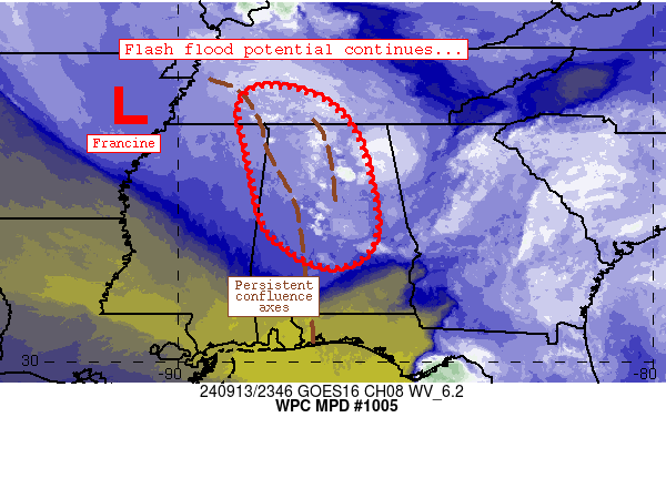
The Weather Prediction Center has issued a discussion talking about the ongoing flood threat for parts of Northern and Central Alabama. Looks like it is going to be a long few hours. The heavy rain bands are expected to continue over the same areas that have been hit with 1-3 inches of rain + over the past 6 hours. There is the possibility that another 1-3″ of rain may fall through the next few hours. Any additional rain will aggravate the flooding. Please be careful through the night.
Category: Alabama's Weather, ALL POSTS, Severe Weather, Social Media


