8am Update: Relentless Tropical Rain; New Advisories for Parts of Northern and Central Alabama
Radar at 758am CDT:
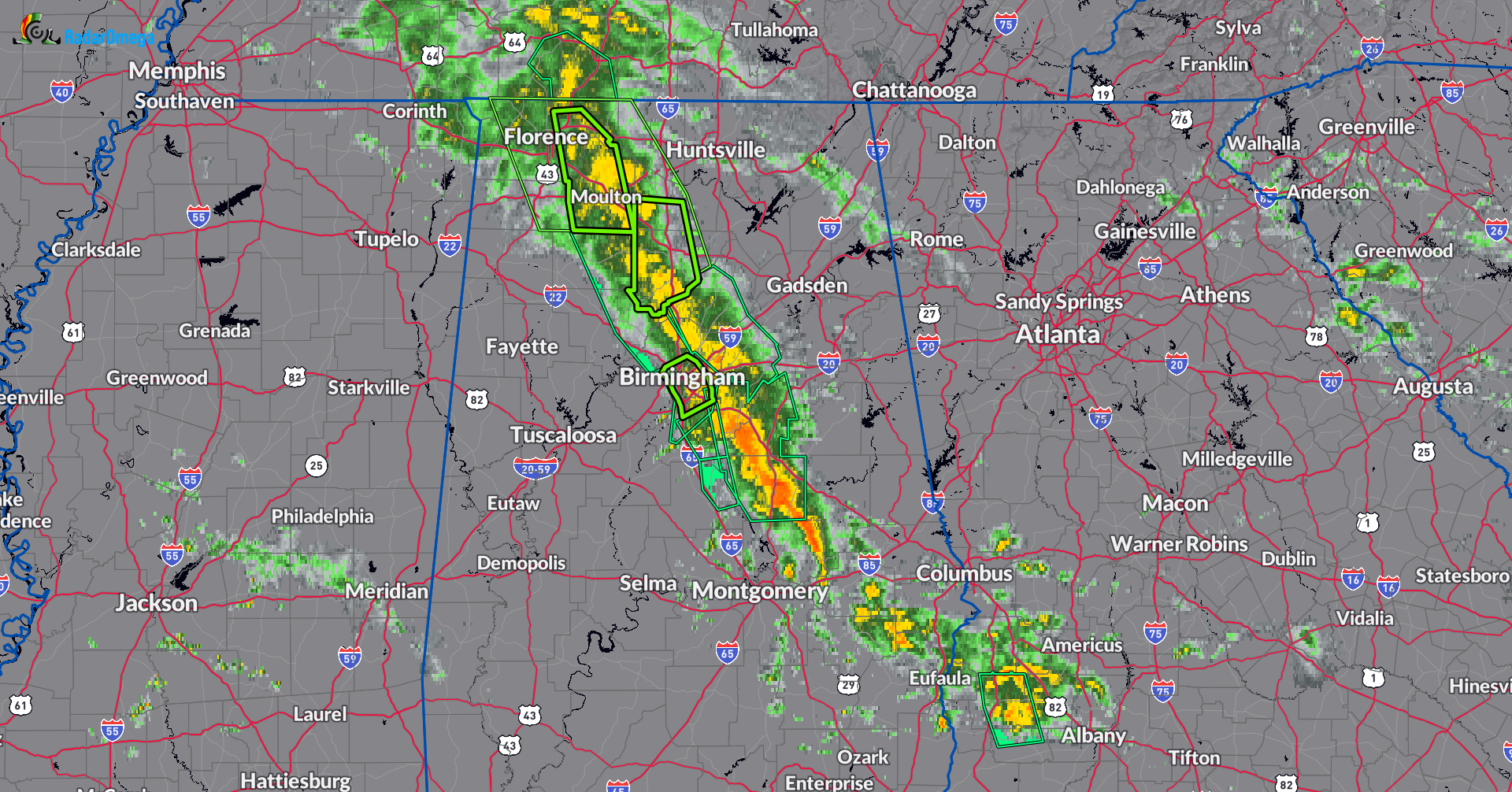
The strong tropical rain band continues to pound portions of Alabama with extremely heavy rain. This is falling on areas that are already waterlogged. My colleague Bill Murray has reported over 2 inches of rain since 6am in Vestavia. 1-2″+ has been common his early morning across the Birmingham metro.
Radar estimates of 6-8 inches over the past 24 hours from Moulton to Arley east to near Decatur and in Western Cullman County.
Backyard flooding in Moulton. 7” of rain since midnight and counting; over a foot during the past two days #alwx @NWSHuntsville @spann @simpsonWVTM13 @AaronA_wx @JDESNOYERSWAFF @mattdanielwx @BryleeWVTM13 @MichaelHaynes @tnvalleyweather pic.twitter.com/SHfDIQLfH2
— Cheneal Wimberley Wx (@dopplerneal) September 14, 2024
Another hard hit area has been further south near Valley Grande and Selma.
Radar suggests rain totals around 8 inches just north of Selma over the past 24 hours pic.twitter.com/ELiJiMYLAC
— James Spann (@spann) September 14, 2024
Here is an overview of the current advisories:
NEW: Flash Flood Warning for…Cullman and Southwestern Morgan Counties unti l1030am
- Still looking at rainfall rates of 1-2″ in an hour.
- This warning encompasses the following communties: Cullman, Hartselle, Hanceville, Good Hope, Falkville, Dodge City,
Baldwin, Vinemont, Somerville, West Point, Eva, Garden City, Colony, Logan, Jones Chapel, Phelan, Battleground, Crane Hill,
Lacon and Smith Lake.
Flash Flood Warning continues for: Southeastern Colbert, Southeastern Lauderdale and Lawrence County until 915am
- This includes: Moulton, Rogersville, Killen, Town Creek, Leighton, Courtland, St. Florian, North Courtland, Hillsboro, Ne Smith, Hatton, Landersville, Wheeler, Whiteoak, Chalybeate Springs, Red Bank, La Grange, Mt Hope, Wren and Ford City.
Flash Flood Warning continues for Southeastern Jefferson and North Central Shelby Counties until 915am
- Some Locations in this warning: Birmingham, Hoover, Vestavia Hills, Homewood, Pelham, Mountain Brook, Gardendale, Irondale, Fultondale, Tarrant, Indian Springs Village, Cahaba Heights, Samford University, Five Points South, The Summit, U.A.B. Campus, Kingston, Regions Field, B.j.c.c. and Birmingham Airport.
Numerous flood advisories are up along this heavy band as well. All or portions of the following counties are included in a flood advisory: Blount, Coosa, Jefferson, St. Clair, Shelby, Talladega, Walker, Winston
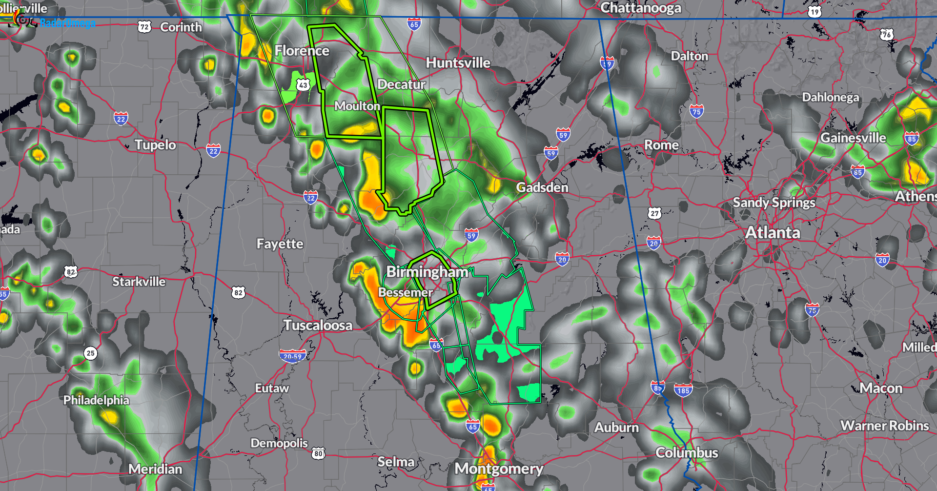
The soupy tropical air mass remains in place today. We will watch the slow movement of this band, which is barely drifting east. The 12Z HRRR is just coming in but over the next couple of hours it does indicated the band could pivot back west/southwest a bit and areas that have already been dealing with heavy rain, may be dealing with it again.
Below is the HRRR project at 11am CDT.
It is one of those days to be weather ready. Make sure to check on friends and neighbors who are in the flood prone areas and are under an advisory. Do not drive on any flooded roadways, it is hard to know the depth of the water.
Category: Alabama's Weather, ALL POSTS, Severe Weather, Social Media
About the Author (Author Profile)
Owner of Tornado Talk. Radio broadcast meteorologist with The Storm Report. WeatherBrains Panelist. B.S. Meteorology from Penn State University.Subscribe
If you enjoyed this article, subscribe to receive more just like it.


