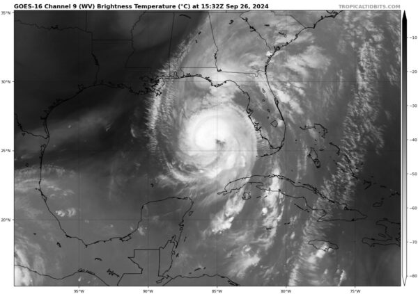
10AM CDT Helene Update: Strengthening Continues; Hurricane Quickly Approaching Florida
The 10AM CDT update from the NHC is here, so let’s get into it.
First, new data as of 10AM CDT from the NHC:
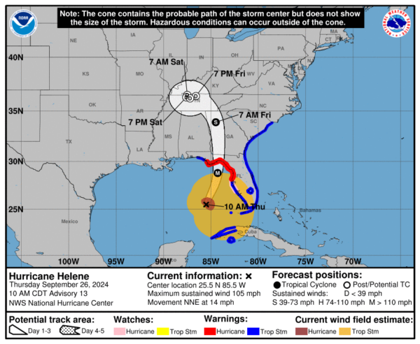
LOCATION…25.5N 85.5W
~255 MI SW OF TAMPA FLORIDA
~290 MI S OF APALACHICOLA FLORIDA
MAXIMUM SUSTAINED WINDS…105 MPH
PRESENT MOVEMENT…NNE AT 14 MPH
MINIMUM CENTRAL PRESSURE…960 MB (28.35 INCHES)
There were no new watches or warnings established in this update, so current watches/warnings remain the same as the previous update.
IMPORTANT UPDATES:
1. Wind speeds have increased by 5 mph since the last update (7AM CDT). This means that Helene is now a strong category 2 hurricane, and is close to becoming a major hurricane. This will likely occur over the next couple of hours. We are still expecting Helene to be a strong category 3 or category 4 hurricane at landfall.
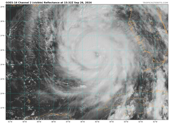
2. Helene has developed an impressive eye as it has moved across the Gulf, and there is now an established eyewall.
3. Tropical storm force winds are already being felt in the southern regions of Florida, as this storm is very large. The NHC notes that the wind field being produced is unusually large compared to previous hurricanes of similar intensity in the Gulf of Mexico. This is the reason behind the extensive hurricane/tropical storm/storm surge warnings.
4. Helene is continuing to pick up speed, and will soon begin to race towards the Big Bend region at a very fast pace.
5. After making landfall, Helene will move across Georgia before stalling over Tennessee. At this point, the storm will be weakened, but impacts are still forecasted for Georgia and South Carolina.
EVACUATION ORDERS:
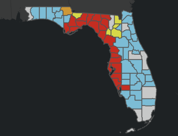
Many counties in Florida have been issued evacuation orders. It is extremely urgent that residents in these counties follow all directions given by local authorities. The map below shows counties that have been issued evacuation orders. Counties shown in red have mandatory evacuation orders, while counties in yellow have voluntary evacuation orders. For more information, please visit: https://www.floridadisaster.org/evacuation-orders/
FORECAST TRACK:
The forecasted track of Helene has not changed much since the last update. Landfall is still expected in the Big Bend area, likely someplace near the coastal areas southeast of Tallahassee, FL. We are expecting landfall to occur this evening, likely between 6-8PM CDT.
STORM SURGE:
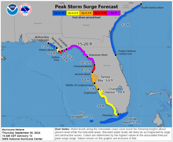
Storm surge forecasts remain the same as the previous update. Life-threatening surge levels of 15-20 ft are expected across the Big Bend Region of Florida, and anywhere from 1-15 ft of surge is expected for most of the other areas along the Florida Gulf Coast.
RAINFALL/FLOODING:
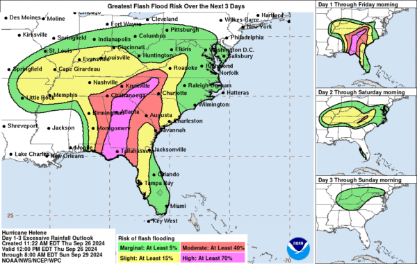
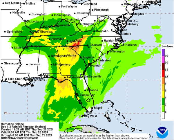
Up to 8 inches of rain are possible near Tallahassee, FL. Higher amounts, such as up to 12 inches, are possible in the Appalachia region. This amount of rain in such a short period will likely lead to flooding, which may occur at any point. Flash flooding will be a large concern once Helene makes landfall.
Flash Flood Risk Areas
Forecasted Rainfall Totals
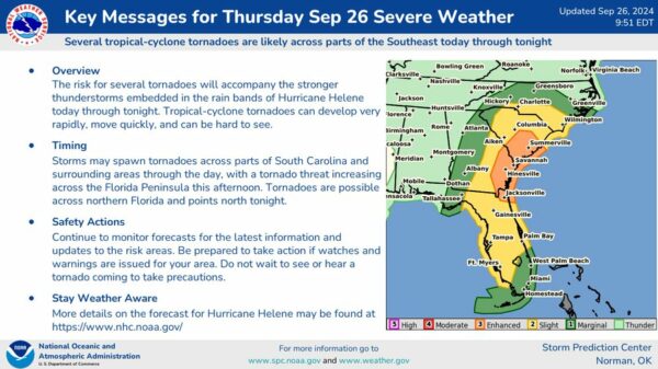
TORNADOES:
Here is the latest information from the SPC regarding Helene-induced severe weather over the coming day:
RADAR AND SATELLITE IMAGES:
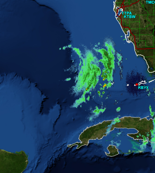
The outer bands of Helene are beginning to be picked up by radar. Important note: Helene is much larger than the image shows, but the entire storm is not in close enough proximity to the radar site to be seen just yet.
Here are some recent satellite images showing Helene:
Please take this situation very seriously if you or anyone you know is located in any of the impact zones. Stay tuned throughout the day as we continue to track this dangerous storm.
Category: ALL POSTS, Social Media, Tropical

