A Few Spotty Showers This Weekend; A Dry Work Week Ahead
THIS WEEKEND:
For today, the remnants of Helene will continue to linger just to our north, bringing a few showers into the northern half of Alabama throughout the day. Showers will be possible mainly along and north of I-20, while it will remain dry to the south. Highs will range from the upper 60s to the mid-80s from north to south. On Sunday, the remnants will start to dissipate and spread over the Tennessee and Ohio River Valleys. Although there will be slightly less cloud cover at times, some showers will remain possible during the afternoon. Highs will range from the mid-70s to the upper 80s.
THE WORK WEEK AHEAD:
Monday will be a dry day across the state with brighter skies, as conditions will be partly to mostly sunny. Highs will range from the upper 70s to the upper 80s. Dry weather will continue on Tuesday with sunny skies expected. We will continue to be warm, with highs in the 80s. A weak boundary will move into the extreme northern parts of the state on Wednesday, pulling in some slightly cooler air. However, it will remain sunny and dry. Highs will range from the upper 70s to the upper 80s. Slightly cooler air will remain in place on Thursday after the boundary exits the area. We’ll stay sunny and dry, with highs in the upper 70s to the mid-80s.
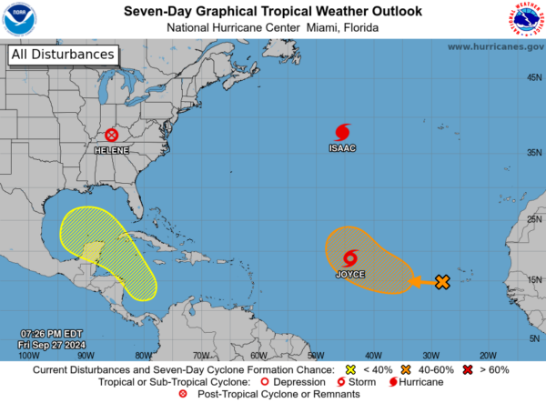
At the end of the forecast period on Friday, sunny and dry weather will continue to prevail over Alabama. However, the GFS is showing a developing system over the Gulf of Mexico moving toward the Mississippi/Alabama Gulf Coasts. We are still too far out to know exactly how this will develop, though the NHC has defined an area where a tropical system may form during this time frame, shown in “The Tropics” section. Highs will be in the upper 70s to the mid-80s.
THE TROPICS:
As of 8 PM Friday evening, we’re tracking four areas of interest in the tropics. First, in the Western Caribbean Sea and Gulf of Mexico, a low-pressure system could form by mid-next week. Conditions are expected to be favorable for slow development as it moves northwest, potentially entering the Gulf by late next week. Currently, the formation chance remains low, near 0 percent over the next 48 hours, and 30 percent over the next 7 days.
In the Eastern and Central Tropical Atlantic, a broad area of low pressure near the Cabo Verde Islands is showing limited shower activity. Gradual development is possible, and a tropical depression could form next week as it moves west-northwest at around 10 mph. There’s a 10 percent chance of formation within 48 hours, and a 40 percent chance over the next 7 days.
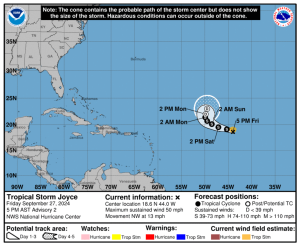
Tropical Storm Joyce is currently located near 18.6°N and 44.0°W, moving northwest at 13 mph. Joyce’s winds have increased to 50 mph, with potential strengthening through early Saturday before weakening gradually next week. Tropical-storm-force winds extend up to 70 miles from the center, and the minimum central pressure is 1001 MB.
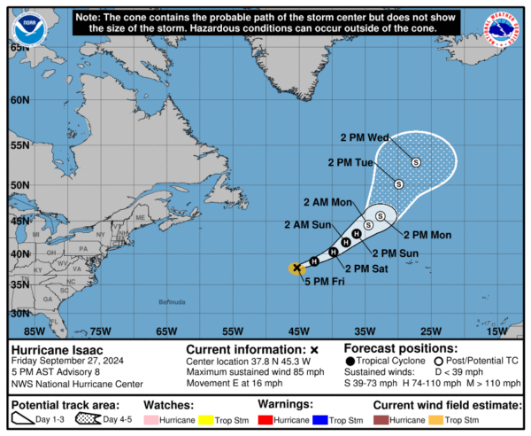
The center of Hurricane Isaac is located near latitude 37.8°N and longitude 45.3°W, moving east at 16 mph. Over the next day, we expect Isaac to gradually shift east-northeast with a slight decrease in forward speed. By Saturday, the storm will begin turning toward the northeast, a motion forecast to continue through Monday. Currently, Isaac’s maximum sustained winds have increased to 85 mph, and slight strengthening could occur tonight or early Saturday before gradual weakening begins next week. Isaac is projected to become a post-tropical cyclone by Monday.
Category: Alabama's Weather, ALL POSTS, Social Media, Tropical, Weather Xtreme Videos


