It Will Finally Begin to Feel Like Fall Next Week
Ridging is the name of the game today as North/Central Alabama will remain dry. Skies will be mostly sunny in the north and partly to mostly cloudy in the south. The ridge will be moving those clouds eastward as it spreads eastward. Highs in the 80s.
As far as college football games, Alabama will be up in Nashville to take on Vanderbilt. Skies will be sunny with very warm temperatures. Game time temperatures will be in the mid to upper 80s.
Auburn will be in the Peach State to take on Georgia. Temperatures will be in the lower 80s throughout the game with partly to mostly sunny skies.
UAB will be at home to take on Tulane at high noon. Skies will be mostly sunny with game time temperatures in the mid 80s.
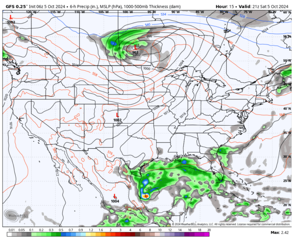
We will be watching developments in the Gulf on Sunday, as both the GFS and European models now have some showers moving across the southern half of the state from this potential mischief. For now, chances are small for showers, while the northern half of the state will remain dry. Highs in the 80s.
A surface high will be set up over the eastern parts of the country on Monday that will begin to usher in some cooler temperatures, which will make it feel like fall through the work week. The moisture from the tropical system will be shunted southward and out of the area, therefore keeping us dry. Highs in the upper 70s to the mid 80s.
We go even cooler on Tuesday as we continue to have a northerly flow over North/Central Alabama. We’ll have sunny skies with highs in the mid 70s to the lower 80s.
Wednesday will be nearly an exact copy of Tuesday’s weather. Sunny skies with highs in the mid 70s to the lower 80s. It also looks like we’ll have a potential hurricane moving inland over the Florida Peninsula.
More dry weather with sunny skies can be expected on Thursday as the tropical system’s influence will keep pulling dry continental air into the state. Highs in the mid 70s to the lower 80s.
And as we end this forecast cycle on Friday, we’ll continue to be sunny and dry with highs in the mid 70s to the lower 80s.
—
Tropical Update as of 6 AM CDT this morning:
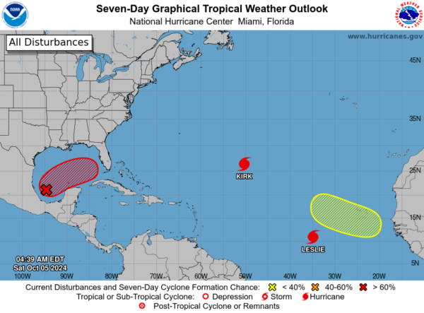
Invest 92L, a broad low-pressure area in the southwestern Gulf of Mexico, is producing winds just below gale force but isn’t yet well-organized. Conditions favor development, with a tropical or subtropical depression or storm likely forming by early next week as it moves east or northeast. Those in the Yucatan, Florida, the Florida Keys, and the Bahamas should monitor the system. Heavy rain is expected in Mexico over the next couple of days and in Florida from late this weekend through mid-next week. There’s a 50% chance of development in 48 hours and 80% over the next 7 days.
A tropical wave is expected to move off the west coast of Africa by Monday or Tuesday, with some development possible later in the week as it moves westward. It could approach the Cabo Verde Islands by Wednesday or Thursday. Formation chances are near 0% in 48 hours but rise to 30% over the next seven days.
Hurricane Kirk remains a strong Category 3 storm with 125 mph winds over the open Atlantic. It’s located 990 miles northeast of the Leeward Islands and 1,575 miles west-southwest of the Azores, moving north-northwest at 13 mph. Kirk will turn north today and speed up northeastward by Sunday. The storm is expected to weaken but remain large. Hurricane-force winds extend 60 miles from the center, with tropical-storm-force winds reaching 220 miles. Large swells will impact the U.S. East Coast, Canada, and the Bahamas by Sunday, with dangerous surf and rip currents. The Azores should prepare for similar conditions by Monday.
Hurricane Leslie has strengthened slightly as it moves across the eastern Atlantic. As of 5 AM AST, it’s about 755 miles west-southwest of the Cabo Verde Islands, moving west-northwest at 7 mph. Leslie’s winds have increased to 80 mph, with some further strengthening possible tonight before weakening begins on Sunday. Hurricane-force winds extend 10 miles from the center, and tropical-storm-force winds reach 70 miles. The current pressure is 985 mb. No watches or warnings are in effect.
Category: Alabama's Weather, ALL POSTS, Social Media, Weather Xtreme Videos


