Tropical Storm Milton: Winds Have Increased and an Eyewall Has Formed
Time to unpack the 10am CDT update on Tropical Storm Milton. Several things to look at including the potential for rapid strengthening with the system and a slight change in the future path. There is some uncertainty in the eventual path and intensity as the models are not all in alignment. The information from the hurricane hunters is KEY to getting a hold on the current state of Milton and its future. Our friends in Florida and along the SE US Coast need to be ready now with their hurricane preparedness plans and be ready to put those plans into action. Let’s get to it:
Stats:
LOCATION…22.4N 94.4W
ABOUT 310 MI…500 KM WNW OF PROGRESO MEXICO
ABOUT 835 MI…1350 KM WSW OF TAMPA FLORIDA
MAXIMUM SUSTAINED WINDS…65 MPH…100 KM/H
PRESENT MOVEMENT…ESE OR 105 DEGREES AT 6 MPH…9 KM/H
MINIMUM CENTRAL PRESSURE…991 MB…29.27 INCHES
Watches and Warnings:
New: The government of Mexico has issued a Tropical Storm Warning for the coast of Mexico from Celestun to Cabo Catoche.
Monitoring: Hurricane and Storm Surge Watches could be required for portions of Florida late today.
- Winds have increased to 65 mph at the center and Milton could become a hurricane later today and then a major hurricane late Monday.
- Pressure has remained steady but that will change.
- Tropical-storm force winds extend out 60 miles from the center.
- For the Tropical Storm Warning area in Mexico, it will be a glancing blow but some gusty winds and about 2-4 inches of rain currently projected.
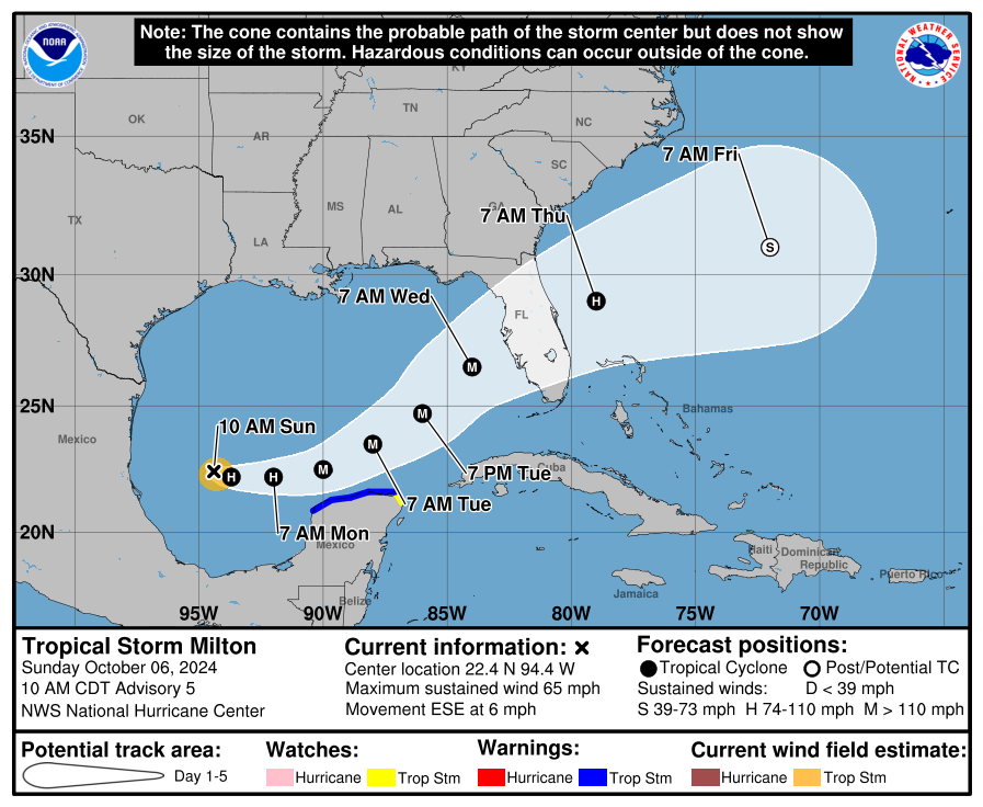
There is a lot to look at in the latest NHC discussion. I will start with this: We will be watching this closely for the next several days and there will be changes and alterations. We will be watching for trends though with what is being seen in real-time and by the hurricane models. There will be widespread impacts for the state of Florida and folks need to pay attention. Where Milton makes landfall is certainly key for worst surge impacts. A landfall south of Tampa Bay helps keep the surge lower for them, but makes it much worse for places like Sarasota or Venice to Punta Gorda. Because of the angle this storm is approaching the west coast of Florida, surge impacts will extend well away from the center.
Strength: There is no doubt Milton will strengthen, it is already doing so and looking much more impressive with an eyewall now forming. The waters are very warm and there is little shear in place ahead of the storm to tear it apart. “Rapid intensification is explicitly forecast….” – that is the wording from the NHC. They forecast at 60 hours out, winds at the center near 120 mph. They also state that may be on the conservative side. The models are showing shear closer to landfall which could weaken the system some BUT could cause the windfield to increase, meaning more widespread winds for a larger area.
Path: The NHC path of the center is slightly south from the previous update. The hurricane models have shown that southward jog and the hurricane hunter aircraft has positioned the center south of where it was previously forecast. That has led to that change from the NHC. If this model trend continues, then further jogs would be implemented into the forecast.
We have a very dangerous situation unfolding for the state of Florida. There will be widespread impacts on the west coast of the state AND inland. There is heavy rain already occurring across the state due to tropical moisture interacting with a front. Some areas are under flood watches now and will be under those all week long. Here is a quick snapshot of the radar for Florida showing areas of moderate to heavy rain for some.
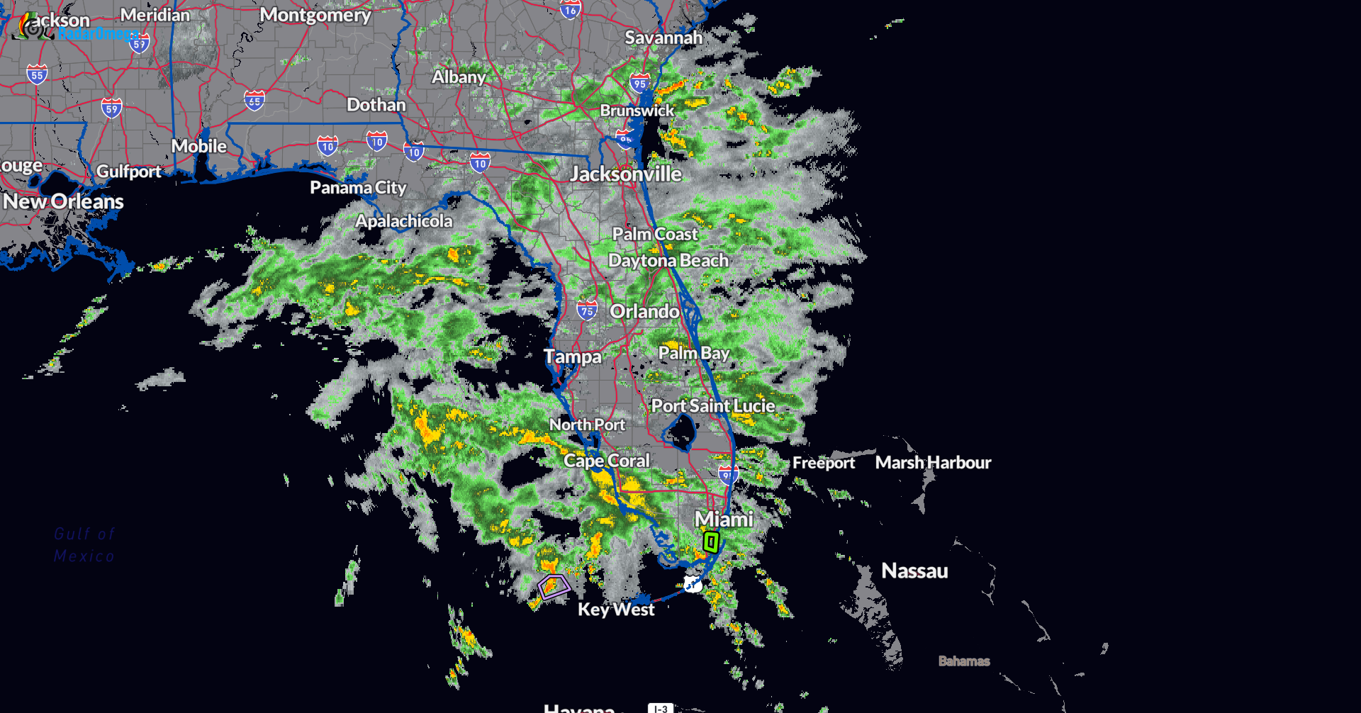
The combination of the heavier rain in the near term followed by rain from Milton could bring tremendous flooding. The NWS Tampa states in their Flood Watch that through Thursday morning, isolated totals of 12 inches a possibility. We will be able to hone in more on who could see the highest rain amounts in the next couple of days.
Storm surge maps have not been generated yet from the NHC but that will be coming. No doubt that life-threatening storm surge is possible for portions of the west coast of the Florida Peninsula and this could begin by late Tuesday or Wednesday.
We will have updates through the event on our blog here and on our X Account! Thank you for following us!
Category: ALL POSTS, Social Media, Tropical
About the Author (Author Profile)
Owner of Tornado Talk. Radio broadcast meteorologist with The Storm Report. WeatherBrains Panelist. B.S. Meteorology from Penn State University.Subscribe
If you enjoyed this article, subscribe to receive more just like it.


