Milton Stronger with Max Winds at 100 mph; Advisories Posted for Parts of Florida
Milton is now a Category 2 storm and numerous watches are up for parts of Florida. We have the latest with the 4am CDT update.
Stats:
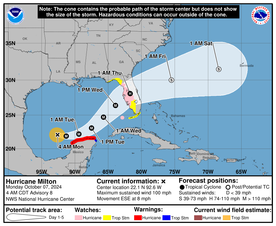
LOCATION…22.1N 92.6W
ABOUT 195 MI…310 KM WNW OF PROGRESO MEXICO
ABOUT 750 MI…1210 KM WSW OF TAMPA FLORIDA
MAXIMUM SUSTAINED WINDS…100 MPH…155 KM/H
PRESENT MOVEMENT…ESE OR 105 DEGREES AT 8 MPH…13 KM/H
MINIMUM CENTRAL PRESSURE…972 MB…28.71 INCHES
——————–
WATCHES AND WARNINGS (There are the new updates)
The Government of Mexico has issued a Hurricane Warning for the coast of the Yucatan Peninsula from Celestun to Rio Lagartos.
A Hurricane Watch is now in effect for the Gulf coast of Florida from Chokoloskee northward to the mouth of the Suwanee River,
including Tampa Bay, and the Dry Tortugas.
A Storm Surge Watch has been issued for the Florida Gulf Coast from Flamingo northward to the Suwannee River, including Charlotte Harbor and Tampa Bay.
A Tropical Storm Watch is now in effect for the Florida Gulf Coast west of the Suwannee River to Indian Pass, and south of Chokoloskee
to Flamingo. A Tropical Storm Watch has also been issued for the Lower, Middle, and Upper Florida Keys, including Florida Bay
Key Points from the NHC Discussion:
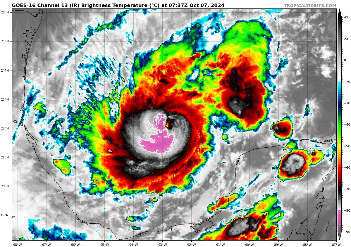
- As you can see from the satellite loop above, Milton has a ragged eye now. It is strengthening and the winds are up to 100 mph at the center.
- As with all tropical systems, you have to look at the surrounding environment to see how their motion will be influenced. In the case of Milton right now, a bit of a southward track has been denoted as it moves within the southern portion of a broad trough in the middle levels of the atmosphere over the Gulf. There is another area of low pressure on the SW side that is helping this steering flow. These low pressure areas are forecast to move east and another one is to head in. This should allow Milton to move ESE then E of the next 36 hours and then a turn to the northeast is projected with a faster pace.
- There will be a landfall in Florida but where the center crosses is still in dispute by the computer models. The NHC states, “The new forecast track calls for the center to reach the Florida west coast between 60-72 h in best agreement with the ECMWF and the multimodel consensus.”
- This track will be adjusted as necessary as guidance comes out through the day. Hurricane hunters will be in the storm all day helping to aid in the information needed.
- The NHC is still forecasting Milton to strengthen rapidly into a Category 4 storm through 36 hours. Shear and dry air entrainment will meet the storm as it approaches the Florida Coast. At that point, we expect a much larger system with a bigger windfield. Regardless of weakening, a dangerous hurricane will be crossing into Florida.
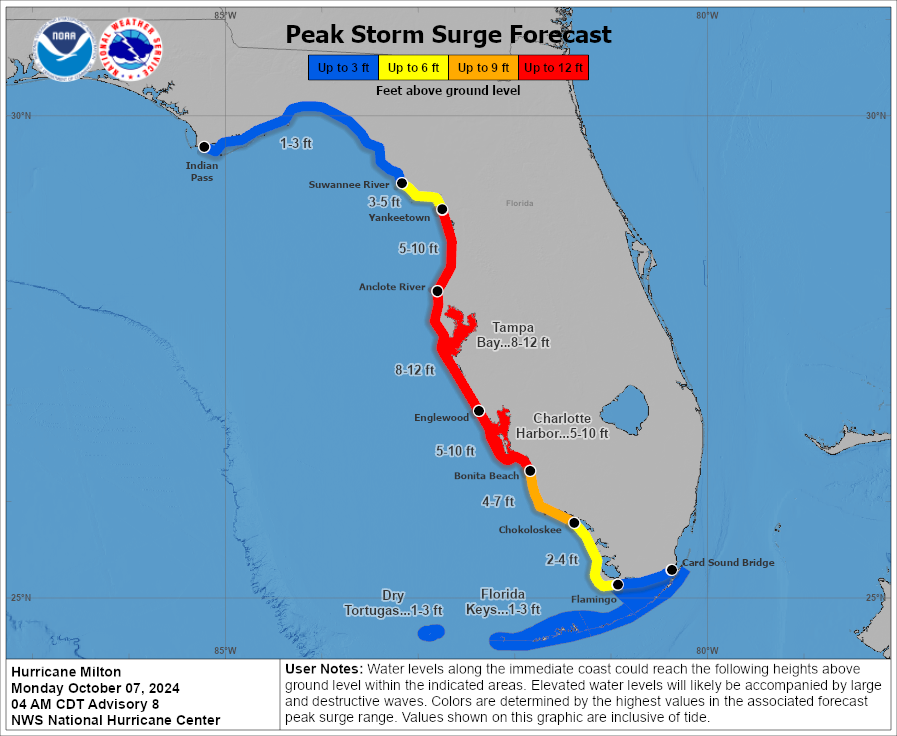
Storm Surge Potential:
We now have our first look at the Peak Storm Surge Forecast maps. Based on the latest track, surge could be between 8-12 feet from Anclote River to Englewood, this includes Tampa Bay. 5-10 foot storm surge from Englewood to Bonita Beach and this includes Charlotte Harbor. Due to the way this storm is coming in, there could be a 1-3 foot surge in the Florida Big Bend area as well.
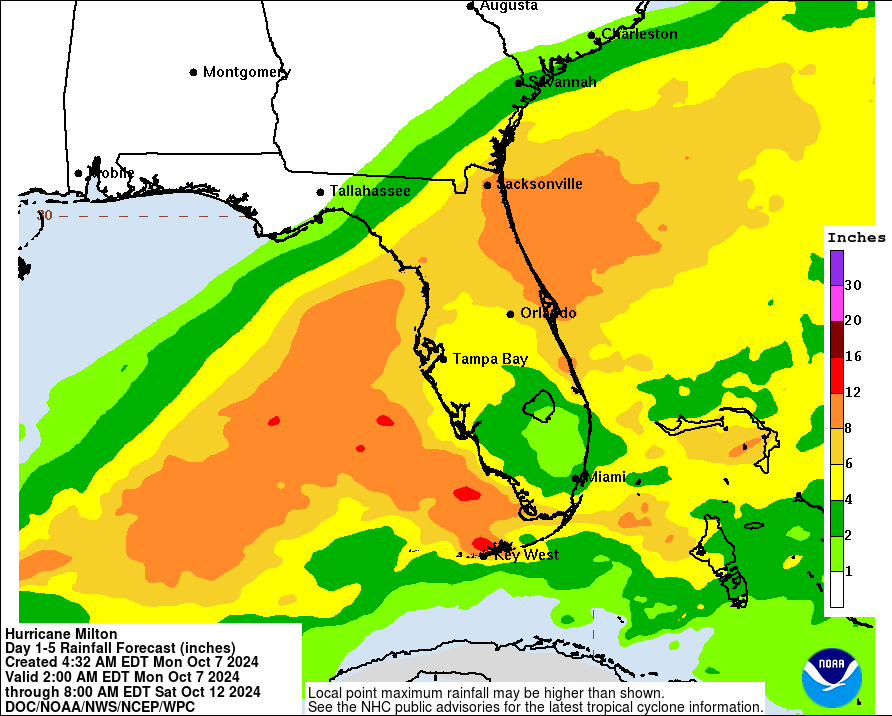
Rainfall:
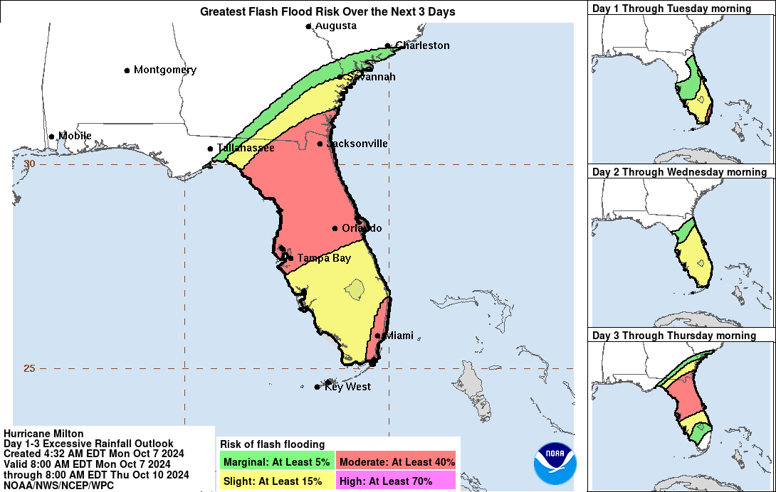
We have mentioned this but it needs to be reiterated, there is already a lot of rain falling across Florida. Deep plume of moisture is interacting with a boundary. Lakes, rivers, streams and creeks are already running high. The rain from Milton will do nothing but add to this and there is a high flooding threat. Some areas could see 12-15 inches of rain. This is not just a threat for the Florida West Coast. But heavy rain is expected across a good part of the Florida peninsula with another peak area from Jacksonville to Melbourne.
Final Thoughts:
It is heart-sinking to wake up to the satellite and see Milton with a ragged eye. It is not shocking though as the storm is in an environment for rapid intensification. Today is the day to act if you are in the state of Florida. If you are along the coast and have been asked to evacuate please do. If you know someone there, encourage them to leave. If you are inland, know this storm will have widespread impacts with the wind, rain and a tornado threat. Be prepared for power outages. Get up those hurricane shutters. Grab the items needed on your hurricane checklist.
Milton is poised to approach the west coast of Florida on Wednesday. That is when the surge and wind impacts will increase. The rain is already across the state and will do nothing but increase. Everyone is hurricane-weary of course and that is more than understandable. Don’t be scared, be prepared. Today is the time to get ready for Milton
Category: ALL POSTS, Social Media, Tropical
About the Author (Author Profile)
Owner of Tornado Talk. Radio broadcast meteorologist with The Storm Report. WeatherBrains Panelist. B.S. Meteorology from Penn State University.Subscribe
If you enjoyed this article, subscribe to receive more just like it.


