Midday Nowcast: Sunny, Chilly November Friday; Active Weather Pattern Next Week
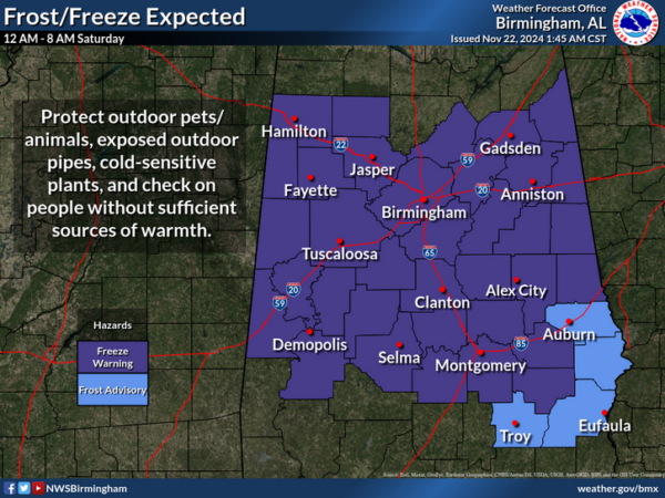
Sunshine, blue sky, and chilly temperatures are the story across Alabama today as afternoon highs are only in the low to mid 50s, while parts of North Alabama will likely remain the 40s. These are a good ten degrees below average for this time of year. Tonight will be clear and cold with lows ranging from the upper 20s to mid 30s across the state, and we are seeing freeze warnings and frost advisories have been issued.
FRIDAY NIGHT LIGHTS: The weather will be clear and cold for the high school playoff games tonight. A clear sky with temperatures falling through the 40s, possibly reaching the 30s by the fourth quarter. Bundle up if heading to the games and take some extra money for hot chocolate.
BIRMINGHAM ALMANAC: For November 22nd, the average high for Birmingham is 63° and the average low is 41°. The record high is 79° set in 1900, while the record low is 20° set in 1964. We average 0.14” of precipitation on this date, and the record value is 2.07” set in 2004.
ACROSS THE USA: Moisture continues to flow into portions of the West, Great Basin and Rockies with strong winds, lower elevation rain and higher elevation snow. Precipitation will occasionally be heavy with impacts to travel and possible power outages. For the Northeast, gusty winds, lower elevation rain and accumulation snow for the higher terrain through this weekend; Slow improvements expected through Sunday.
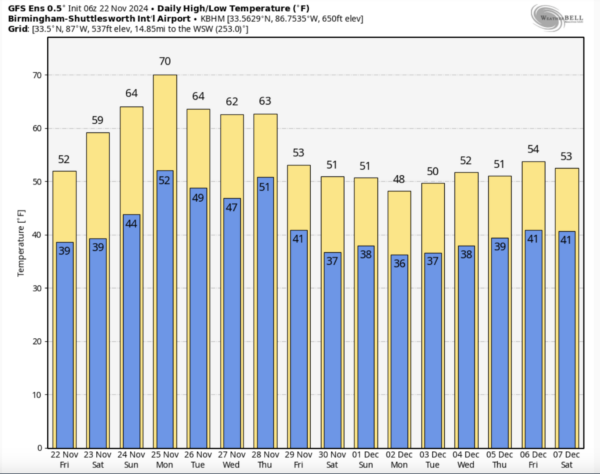
WEEKEND WEATHER: Tomorrow morning will be our coldest and under a sky full of sunshine, highs will be in the 50s across the northern half of the state. Tomorrow night will again be clear and cold with lows in the low to mid 30s, then temperatures rise into the 60s Sunday. It will be a gorgeous weekend of weather, just make sure you bundle up!
FOOTBALL WEATHER: Tomorrow UAB will host Rice at Protective Stadium (1:00p CT kickoff)… the sky will be sunny with temperatures in the mid 50s.
Auburn hosts Texas A&M at Jordan-Hare Stadium (6:30p CT kickoff)… it will be a clear, cold evening in Lee County with temperatures falling through the 40s.
Alabama will be on the road; they take on Oklahoma in Norman (6:30p CT kickoff)… expect a clear sky with temperatures in the 50s.
THANKSGIVING WEEK: Next week looks to be active across the Deep South. Monday will be the warmest day of the week with a high in the low to mid 70s. A cold front will bring some risk of isolated showers late Monday night and into Tuesday, but moisture will be limited and rain amounts will be light and spotty. Wednesday looks generally dry for now; highs will be in the 60s Tuesday/Wednesday.
As we get to Thanksgiving Day, it looks like it will be wet and potentially stormy with a cold front approaching. Still too early to know if severe storms will be an issue, but it is certainly possible. Behind the front, much colder air follows the front, likely the coldest air so far this season as the weather looks cold and dry Friday through the weekend with highs in the upper 40s and lower 50s and lows likely heading down into the 20s. Then as we head into the month of December, the overall pattern looks to be cold with well-below average temperatures expected.
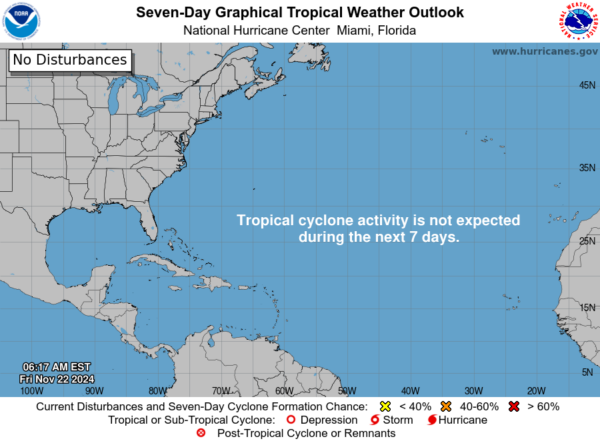
IN THE TROPICS: The Atlantic Basin is quiet with no tropical development expected the next seven days. Hurricane ends on November 30th.
WORLD TEMPERATURE EXTREMES: Over the last 24 hours, the highest observation outside the U.S. was 106.0F at Nukuoro Atoll, Federated States of Micronesia. The lowest observation was -63.6F at Dome A, Antarctica.
CONTIGUOUS TEMPERATURE EXTREMES: Over the last 24 hours, the highest observation was 88F at Catalina Foothills, AZ. The lowest observation was -5F at Peter Sinks, UT.
Category: Alabama's Weather, ALL POSTS, Social Media
About the Author (Author Profile)
Macon, Georgia Television Chief Meteorologist, Birmingham native, and long time Contributor on AlabamaWX. Stormchaser. I did not choose Weather, it chose Me. College Football Fanatic. @Ryan_StinnetSubscribe
If you enjoyed this article, subscribe to receive more just like it.


