EXPIRED – Severe T-Storm Warning for Parts of Greene, Pickens, Sumter Co. Until 10:15PM
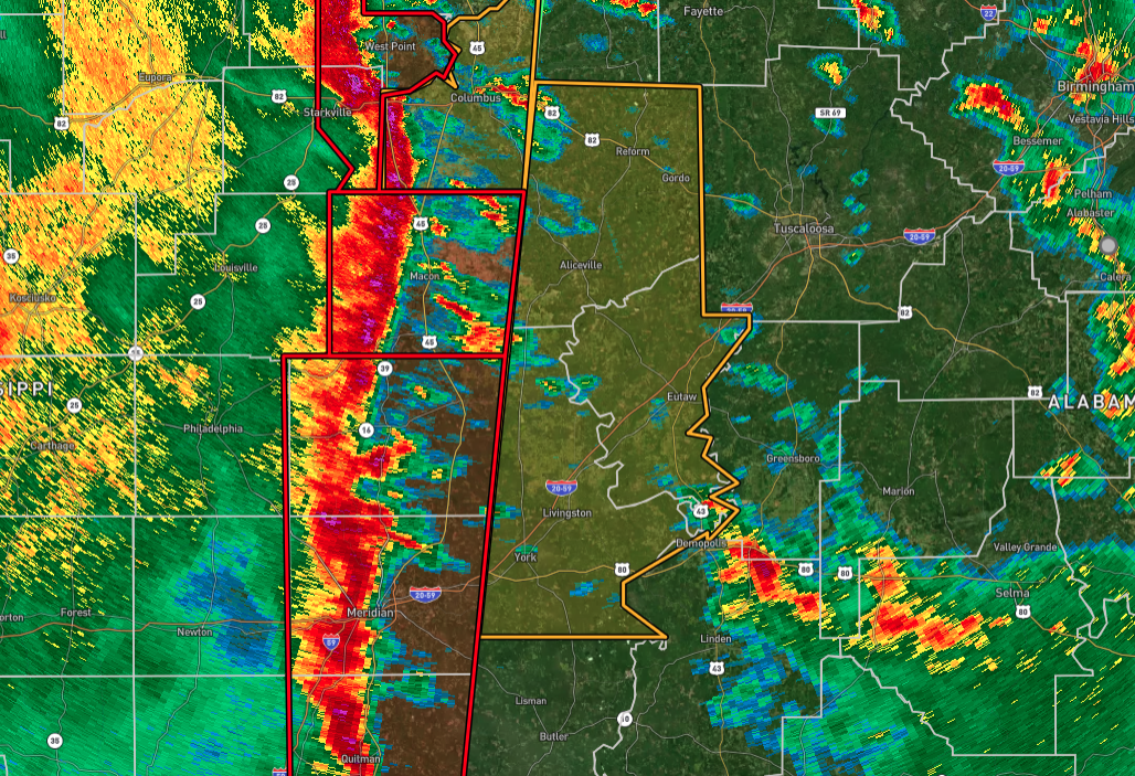
The National Weather Service in Birmingham has issued a Severe Thunderstorm Warning for Pickens, Greene, and Sumter counties in west-central Alabama, effective until 10:15 PM CST. At 8:55 PM CST, severe thunderstorms were observed along a line stretching from near Crawford to near Meridian, moving east at 45 mph. These storms are capable of producing wind gusts of up to 70 mph, which can cause significant tree damage and are likely to damage mobile homes, roofs, and outbuildings.
Locations expected to be impacted include Demopolis, Livingston, Eutaw, York, Aliceville, Gordo, Reform, Carrollton, Pickensville, Cuba, Forkland, Boligee, Union, Gainesville, Epes, Ethelsville, Emelle, Memphis, McMullen, and Panola.
This is a dangerous situation, as these storms are producing widespread wind damage across central Mississippi. Residents in the warned area should seek shelter immediately in a sturdy structure and stay away from windows. Intense thunderstorm lines like this one can produce brief tornadoes and widespread, significant wind damage. While a tornado is not immediately likely, it is safest to move to an interior room on the lowest floor of a building. These storms have the potential to cause serious injury and significant property damage.
A Tornado Watch remains in effect until 4:00 AM CST for southwestern and west-central Alabama. Stay alert and monitor for further updates as the situation evolves.
Category: Alabama's Weather, ALL POSTS, Severe Weather, Social Media
About the Author (Author Profile)
Scott Martin is an operational meteorologist, professional graphic artist, musician, husband, and father. Not only is Scott a member of the National Weather Association, but he is also the Central Alabama Chapter of the NWA president. Scott is also the co-founder of Racecast Weather, which provides forecasts for many racing series across the USA. He also supplies forecasts for the BassMaster Elite Series events including the BassMaster Classic.Subscribe
If you enjoyed this article, subscribe to receive more just like it.


