EXPIRED – Severe T-Storm Warning for Lamar Co. Until 10PM
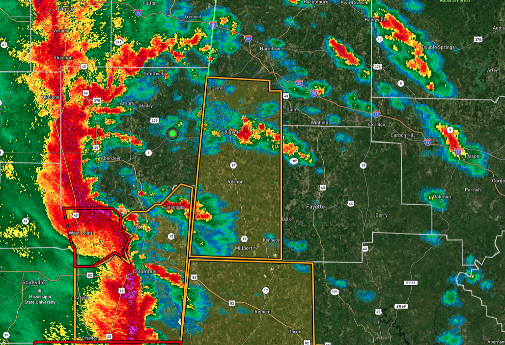
The National Weather Service in Birmingham has issued a Severe Thunderstorm Warning for Lamar County in west-central Alabama, effective until 10:00 PM CST. At 9:06 PM CST, severe thunderstorms were located along a line extending from Verona to near Bent Oak, moving northeast at 55 mph. These storms are capable of producing wind gusts up to 60 mph, which could result in damage to roofs, siding, and trees.
Areas expected to be impacted include Vernon, Sulligent, Millport, Kennedy, Detroit, Beaverton, Blooming Grove, Lamar County Airport, Crews, Bedford, Crossville, Cody, Henson Springs, Lamar County Public Lake, Star, Pine Springs, Hightogy, and Melborne.
This is a dangerous situation as these storms have been producing widespread wind damage across central Mississippi. Residents should seek shelter immediately in a sturdy structure, staying away from windows. While tornadoes are not currently expected, intense thunderstorm lines like this one can produce brief tornadoes and widespread significant wind damage. The safest action is to move to an interior room on the lowest floor of a building to protect against serious injury and property damage.
A Tornado Watch remains in effect until 4:00 AM CST for northwestern and west-central Alabama. Stay alert and monitor weather updates as the situation develops.
Category: Alabama's Weather, ALL POSTS, Severe Weather, Social Media
About the Author (Author Profile)
Scott Martin is an operational meteorologist, professional graphic artist, musician, husband, and father. Not only is Scott a member of the National Weather Association, but he is also the Central Alabama Chapter of the NWA president. Scott is also the co-founder of Racecast Weather, which provides forecasts for many racing series across the USA. He also supplies forecasts for the BassMaster Elite Series events including the BassMaster Classic.Subscribe
If you enjoyed this article, subscribe to receive more just like it.


