Sunday Weather Briefing Video: Beware A Little Freezing Fog and Black Ice Early This Morning
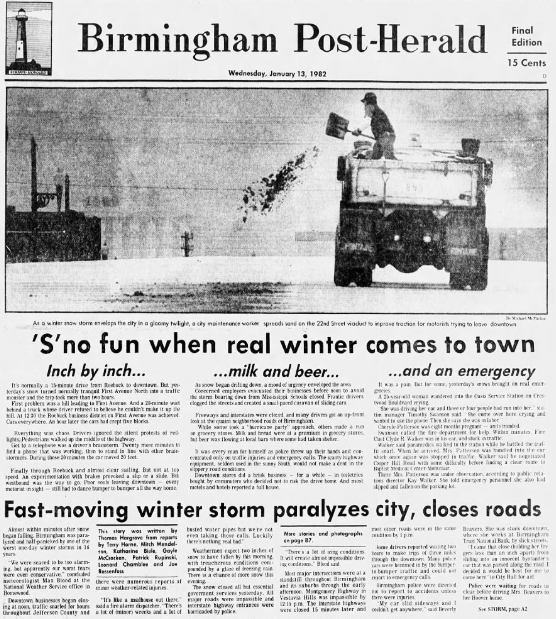
Birmingham Post-Herald the morning after the 1982 Ice Storm
January 12, 1982 is a red letter date for me and the state of Alabama in weather history. I was a student at Samford University, but it was Jan term, and I was off that mini-term. I had alerted my job that snow and ice were going to be a problem and that they needed to call people in (my first corporate snow forecast) but they weren’t taking it seriously. So I had the day off. I remember waking up in the pre-dawn hours to J.B. Elliott on NOAA Weatheradio giving reports from southwestern Alabama where snow was already falling. The wintry weather was arriving earlier than expected.
SATURDAY RECAP: Yesterday was a dry and cold day across North and Central Alabama with highs in the mid to upper 30s to mid 40s. The leftover snow made for a beautiful scene in many areas, even as the sun worked its magic to melt the slush and dry roads. But some roads were still wet as readings fell below freezing last night, and that means black ice will be a problem through the early morning hours for your Sunday. Please use extreme caution if driving. There will even be some freezing fog, especially across North and North Central Alabama overnight, and this can cause ice to accumulate on exposed objects like bridges.
Cold, dry air will dominate the region tonight, leading to frigid overnight temperatures across Central Alabama. With calm winds and clear skies, efficient radiational cooling will allow temperatures to drop into the upper teens across the northern counties and the lower 20s farther south. Patchy freezing fog may develop in low-lying areas, especially in the northern tier of the region, but impacts should remain minimal through early Sunday morning.
ON SUNDAY: A gradual transition to southwesterly flow will begin as high pressure shifts eastward. This shift in wind direction will result in slightly warmer conditions, with highs reaching the low 40s in northern areas and the low 50s in the south. Moisture will increase late in the day, especially across southwestern portions of the region, ahead of an approaching weak disturbance. Clouds will increase during the evening, with rain chances rising overnight into Monday morning.
WEEK’S FIRST RAINMAKER: Sunday night into Monday will feature the arrival of the first rainmaker of the week. Both the GFS and ECMWF models suggest that temperatures will remain above freezing, so any chance of wintry precipitation at the onset will be extremely low. Rainfall amounts will likely be light to moderate, and any lingering showers should taper off by Monday afternoon. Conditions will then dry out quickly as a ridge of high pressure builds back into the region.
MIDWEEK: By midweek, a steady warming trend will be underway as southwesterly flow continues. Daytime highs are expected to rise into the mid to upper 50s, with overnight lows moderating into the mid 30s to lower 40s. Dry weather will persist during this period, with mostly sunny skies expected through Thursday.
LATE WEEK: Toward the end of the week, another storm system will approach from the west, bringing increased rain chances beginning Friday morning. This system looks more robust than the early-week disturbance, and widespread rainfall is likely through Friday into Saturday. Although temperatures will remain well above freezing, heavy rain may lead to localized flooding concerns in low-lying or poorly drained areas.
BEACHCAST: All indications are that low pressure will move along the northern Gulf Coast by late Sunday, into Monday, spreading a cold rain with it. High temperatures will warm back into the 50s today and stay there through midweek after a chilly start this morning. Lows Monday morning will be in the 40s, with 30s the rest of the week in the wake of the disturbance. It will become breezy along the coast by early Tuesday with gusts to 20-25 mph. They will stay gusty on Wednesday as well. Water temperatures along the coast are in the upper 50s. The rip current risk will remain low through midweek.
Click here to see the Beach Forecast Center page.
NATIONALLY: The fire weather threat will be front and center again today and Tuesday across Southern California. It will affect places like Riverside, San Bernadino, Ontario, Fontana, and Santa Clarita, California, surrounding the Los Angeles area. Heavy rain will be a threat by next weekend across the Gulf Coastal states, including Alabama.
DANCING WITH THE STATS: The 2 inches of snow at the Shuttlesworth Birmingham International Airport was the most since a 4” snowfall on December 8, 2017. The 7.5 inches of snow at Memphis made it the single snowiest day in 40 years there, since January 3, 1985.
WEATHERBRAINS: This week was a very moving show with Trisha Palmer from the NWS Greenville/Spartanburg, South Carolina, and Geologist Philip Prince. They joined the panel to talk about Hurricane Helene and its impact in the Carolinas. It is a show you shouldn’t miss. Check out the show at www.WeatherBrains.com. You can also subscribe on iTunes. You can watch the show live on our new YouTube channel for the show and you can see the live show on the James Spann 24×7 weather channel on cable or directly over the air on the dot 2 feed.
ON THIS DATE IN 2023: 14 tornadoes plagued Alabama as a strong cold front moved across the state. Nine of the tornadoes impacted the NWS Birmingham’s County Warning Area, including 5 EF-2 tornadoes and 1 EF-3. The EF-3 was on the ground for over 76 miles from Autauga to Chambers County. That was the one killer tornado, resulting in 7 fatalities. The NWS Mobile documented three tornadoes including one EF-2 in northern Mobile County. An early morning tornado in the Huntsville CWA was on the ground for 30.4 miles across Lawrence, Morgan, and Limestone County. The 13 tornadoes that occurred on the 12th and an event earlier in the month that produced 14 tornadoes established a new record for January Alabama tornadoes. The previous record was 21 in January 2017. Follow my weather history tweets on Twitter. I am @wxhistorian at Twitter.com.
Category: Alabama's Weather, ALL POSTS, Social Media, Winter Weather
About the Author (Author Profile)
Bill Murray is the President of The Weather Factory. He is the site's official weather historian and a weekend forecaster. He also anchors the site's severe weather coverage. Bill Murray is the proud holder of National Weather Association Digital Seal #0001 @wxhistorianSubscribe
If you enjoyed this article, subscribe to receive more just like it.


