Sunday Briefing Video: Bitter Cold Arrives…Winter Weather Threat Looms
The powerful Arctic front has swept through Alabama, ushering in a dramatically colder air mass. Temperatures early this morning have already plunged into the 20s and 30s, and there will be little recovery through the day. Highs will struggle to reach the mid-30s to mid-40s under a gusty north wind of 25-30 mph, making it feel even colder. A few flurries or light snow showers are possible across northern Alabama through late afternoon, but no significant accumulations are expected.
DANGEROUS COLD TONIGHT INTO MONDAY MORNING: The most significant immediate concern is the dangerous cold expected tonight into Monday morning. Temperatures will plummet into the teens across most of the area, with some single-digit readings possible in the northeast. A biting north wind will push wind chills near or below zero in the northern counties, with values of 5-10 degrees farther south. An Extreme Cold Warning is in effect for Jefferson, Blount, Calhoun, Cherokee, Cleburne, Etowah, and St. Clair counties, where the worst conditions are expected. Elsewhere, a Cold Weather Advisory will cover much of Central and South Alabama.
MONDAY BRINGS LITTLE RELIEF: Despite full sunshine on Monday, Arctic air will remain firmly in place. Highs will only reach the upper 20s and lower 30s in the north, with mid-30s farther south. Winds will ease slightly but remain out of the north at 5-10 mph. Another frigid night is in store Monday night, with lows dropping back into the mid-teens to near 20 degrees. Wind chills will remain in the single digits in many locations, prompting another Cold Weather Advisory into Tuesday morning.
WINTER STORM WATCH FOR TUESDAY: Attention then shifts to a developing winter storm system set to impact Alabama on Tuesday. A potent upper-level disturbance will interact with Gulf moisture, leading to widespread precipitation across the state. With cold air already in place, areas south of I-20, including Montgomery, Auburn, Tuscaloosa, and Demopolis, are at risk of accumulating snow. A Winter Storm Watch has been issued for much of Central and South Alabama, where travel disruptions are likely.
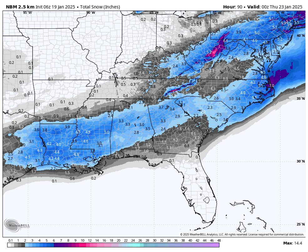
Snow totals from the National Blend of Models
SNOW ACCUMULATIONS AND TIMING: The first flakes could start falling Tuesday morning, with snow becoming more widespread through the afternoon and evening. Accumulations of 1-2 inches are possible, with some localized spots seeing 3 inches or more, particularly along the I-85 and U.S. 80 corridors. Temperatures will drop quickly Tuesday night, leading to refreezing of any melted snow and the development of hazardous black ice on roads. Travel impacts could extend into Wednesday morning.
MIXED PRECIPITATION POSSIBLE: Some forecast models suggest a layer of warm air aloft could lead to a mix of sleet and freezing rain in portions of South Alabama, especially from Evergreen to Mobile and Pensacola. If freezing rain occurs, even small amounts could create slick road conditions and isolated power outages. Forecast details on precipitation types and amounts will be refined in the coming updates.
IMPROVING WEATHER MIDWEEK: The winter storm system will exit by Wednesday morning, but cold air will remain locked in place. Highs on Wednesday will again struggle to get above freezing in many areas, with morning lows in the teens and 20s. The good news is that drier conditions will settle in, allowing roads to gradually improve by Wednesday afternoon as temperatures rise slightly above freezing.
SLOW WARMUP LATE WEEK: By Thursday and Friday, temperatures will slowly moderate, with highs climbing into the 40s and possibly near 50 degrees by Friday. Nights will still be cold, with lows in the 20s and 30s. A gradual return to near-normal temperatures is expected next weekend, with highs in the 50s and a chance of rain by Saturday as another frontal system approaches.
PLEASE TAKE THIS THREAT SERIOUSLY: This is a serious cold outbreak for Alabama, with dangerous wind chills, potential accumulating snow, and travel disruptions expected. Stay updated with forecast changes, take precautions to protect people, pets, pipes, and plants from freezing temperatures, and prepare for hazardous road conditions Tuesday into Wednesday.
Category: Alabama's Weather, ALL POSTS, Social Media, Winter Weather
About the Author (Author Profile)
Bill Murray is the President of The Weather Factory. He is the site's official weather historian and a weekend forecaster. He also anchors the site's severe weather coverage. Bill Murray is the proud holder of National Weather Association Digital Seal #0001 @wxhistorianSubscribe
If you enjoyed this article, subscribe to receive more just like it.


