Winter Storm Watches Issued for Central and South Alabama, Advisories/Warning for Cold/Extreme Cold For all of the State
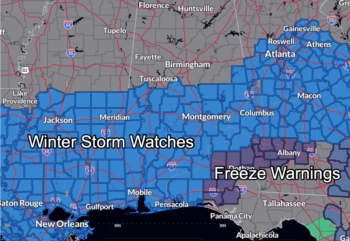
NWS offices in Birmingham and Mobile have issued winter storm watches for Tuesday morning through late Tuesday night.
Up to three inches of snow is possible in the watch area, with a light glaze of freezing rain over far southern Alabama possible as well.
The midnight models runs have trended further south with the precipitation and there is good consistency between the GFS and the European. The Canadian remains an outlier on the northern extent, with higher amounts further north into Central Alabama.
But confidence has increased in the chance of wintry precipitation over ALL of Central Alabama for Tuesday and Tuesday night, and winter weather advisories may be needed for the I-20 Corridor in later forecast packages. Winter weather impacts from snow could also affect the Tuscalooosa, Jasper, Birmingham, Cullman, Gadsden, and Anniston areas as well, including travel disruptions and closing. Amounts could be as high as 1-2 inches in some areas.
Roads will quickly become hazardous with the snow and roads will remain snow covered and icy through Tuesday night and perhaps much of Wednesday.
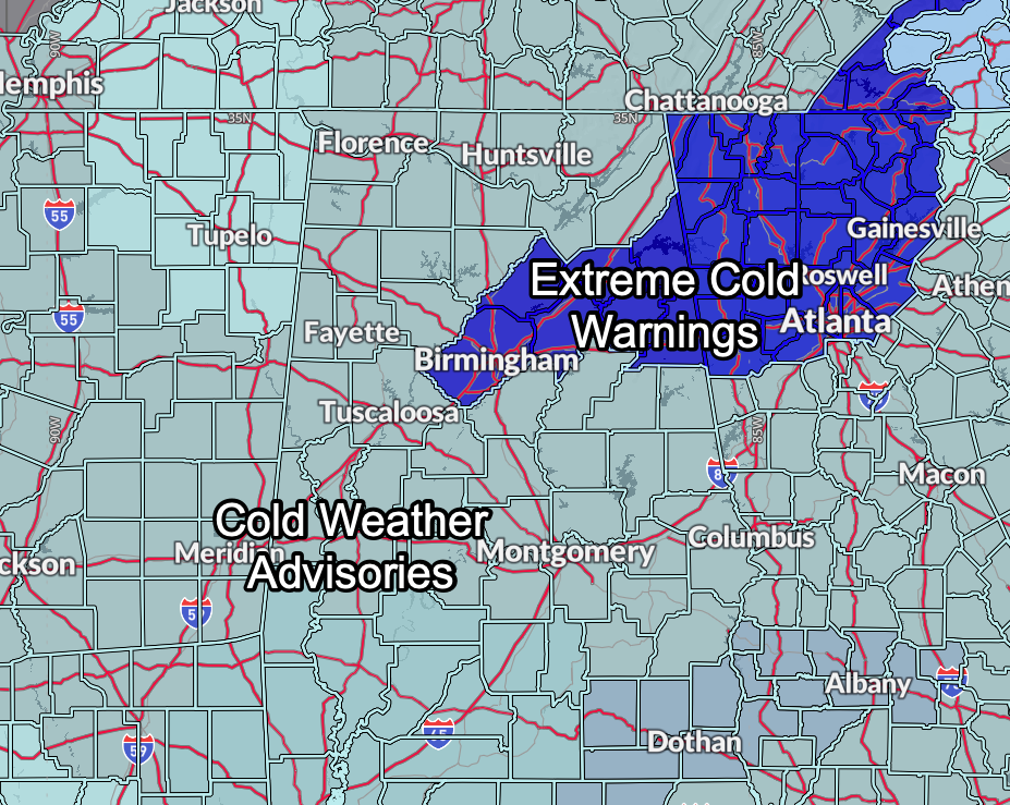
The cold weather advisories now cover all of the state of Alabama, except for Jefferson, Blount, Etowah, Calhoun, Cherokee, Cleburne, and St. Clair counties, which were upgraded to an Extreme Cold Warning for especially dangerous wind chill temperatures as low as zero in these counties from midnight tonight until 11 a.m. Monday.
Elsewhere in the advisory area, wind chills tonight and Monday morning could reach 2F.
The cold weather advisories will continue all week.
URGENT – WINTER WEATHER MESSAGE
National Weather Service Birmingham AL
301 AM CST Sun Jan 19 2025
ALZ029>050-192115-
/O.NEW.KBMX.WS.A.0002.250121T1200Z-250122T1200Z/
Randolph-Sumter-Greene-Hale-Perry-Bibb-Chilton-Coosa-Tallapoosa-
Chambers-Marengo-Dallas-Autauga-Lowndes-Elmore-Montgomery-Macon-
Bullock-Lee-Russell-Pike-Barbour-
Including the cities of Tuskegee, Marion, Centreville,
Moundville, Demopolis, Fort Deposit, Troy, Prattville,
Montgomery, Union Springs, Alexander City, Lafayette, Tallassee,
Auburn, Wetumpka, Phenix City, Selma, Opelika, Livingston,
Clanton, Lanett, Eutaw, Valley, Hayneville, Greensboro, Roanoke,
Linden, Rockford, Dadeville, and Eufaula
301 AM CST Sun Jan 19 2025
…WINTER STORM WATCH IN EFFECT FROM TUESDAY MORNING THROUGH LATE
TUESDAY NIGHT…
* WHAT…Light to moderate snow is forecast with total accumulations
up to three inches possible.
* WHERE…Autauga, Barbour, Bibb, Bullock, Chambers, Chilton, Coosa,
Dallas, Elmore, Greene, Hale, Lee, Lowndes, Macon, Marengo,
Montgomery, Perry, Pike, Randolph, Russell, Sumter, and Tallapoosa
Counties.
* WHEN…From Tuesday morning through late Tuesday night.
* IMPACTS…Roads, and especially bridges and overpasses, will
likely become slick and hazardous. Travel could be very difficult.
The hazardous conditions could impact the Tuesday morning and
evening commutes, as well as the Wednesday morning commute.
PRECAUTIONARY/PREPAREDNESS ACTIONS…
Monitor the latest forecasts for updates on this situation.
Category: Alabama's Weather, ALL POSTS, Social Media, Winter Weather
About the Author (Author Profile)
Bill Murray is the President of The Weather Factory. He is the site's official weather historian and a weekend forecaster. He also anchors the site's severe weather coverage. Bill Murray is the proud holder of National Weather Association Digital Seal #0001 @wxhistorianSubscribe
If you enjoyed this article, subscribe to receive more just like it.


