Winter Storm Fully Underway; Here Is A Road Condition And Radar Update
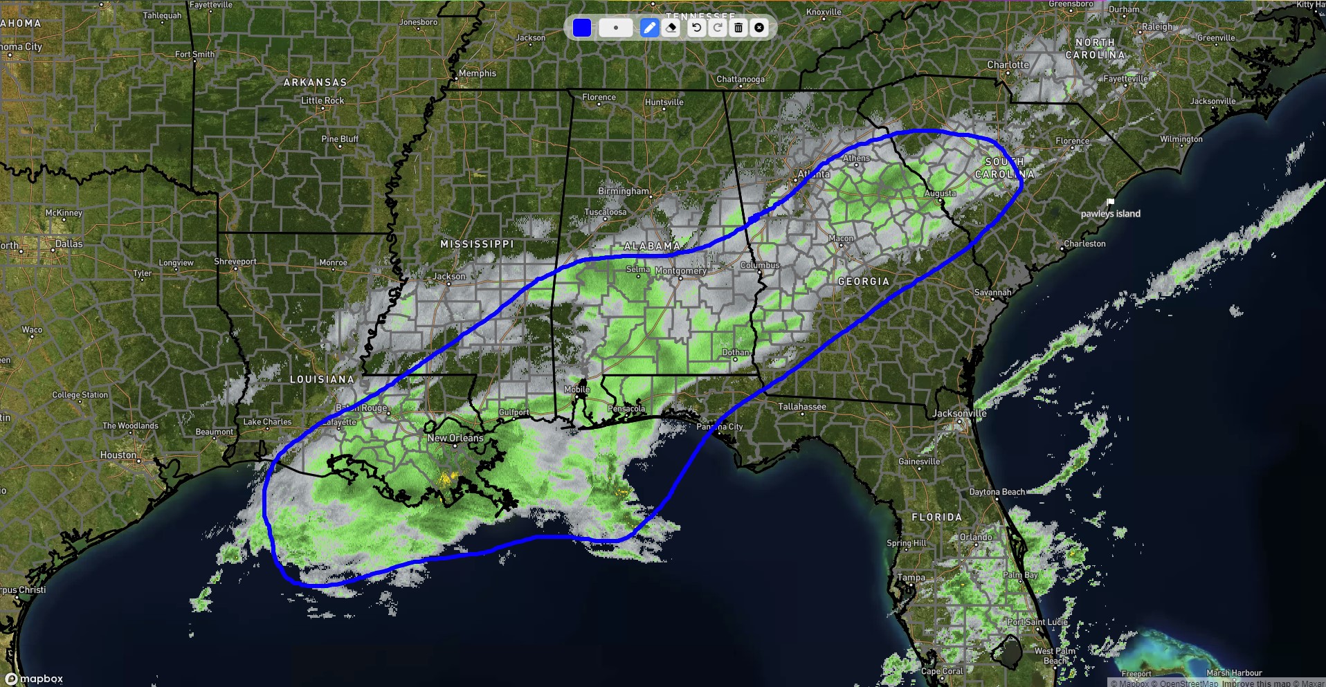
As of shortly after 1pm cst this afternoon, composite radar shows snow across a large portion of the deep south circled in blue. Some of this, mainly north of I20 in Alabama is not making it to the ground (virga). However, there are bands of heavy snow across much of southern Louisiana, southern Mississippi, and southern Alabama that will continue throughout the afternoon and into this evening. In fact, the dynamics at play with this storm are so strong that thundersnow was reported in Louisiana earlier today! This area of snow will continue to move to the east/northeast throughout the remainder of today.
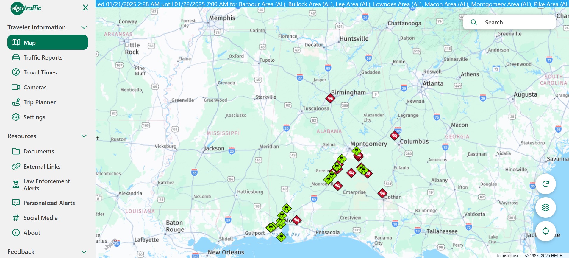
Per the ALGO traffic site, roads are beginning to become snow covered or icy across the southern portion of the state where snow is falling. Over the next several hours, we expect roadways in these areas to continue to worsen with travel difficulties becoming more significant and widespread. The worst will be contained within the winter storm warning area, but some impacts cannot be ruled out as far north as I-20. According to Barbour county emergency management, all roads in the county are considered impassible and a travel advisory has been issued until further notice effective beginning at 3pm this afternoon. Similar conditions are also being reported in Montgomery county, with all county roads being closed south of Hope Hull.
Back in Louisiana, as much as 10″ of snow has been recorded, with widespread amounts of 5-8″ across the southern part of the state. So far, snow amounts have been light, less than 1″ across most of central Alabama. However, down in the southwest part of the state, heavy snow has occured with snowfall reports in the 1-3″ range so far. Some examples include:
Daphne: 3″
Brewton: 3″
Andalusia: 1.5:
Grand bay: 3″
Fairhope: 2″
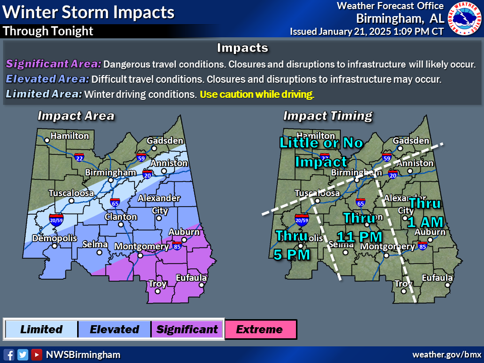
Winter storm warnings remain in place for the southern 1/3 of the state, with winter weather advisories up to areas just south of the I-20 corridor in central AL. This remains well outlined in this graphic by NWS Birmingham in the elevated and significant impact areas where there is the highest chance for dangerous travel conditions, delays, and closures, particularly in the winter storm warning area. Please avoid travel today unless its an emergency. And if you must travel, use extreme caution and ensure you have emergency supplies in your vehicle incase you get stranded.
Category: Alabama's Weather, ALL POSTS, Social Media
About the Author (Author Profile)
Jack is a junior at Mississippi State University studying meteorology. He has several years of forecasting experience through a local group of forecasters in Maryland where he resides. Jack plans to become a broadcast meteorologist after graduation.Subscribe
If you enjoyed this article, subscribe to receive more just like it.


