Latest Details on This Mornings Winter Weather Mischief; Plus, an Updated Closings & Delays List
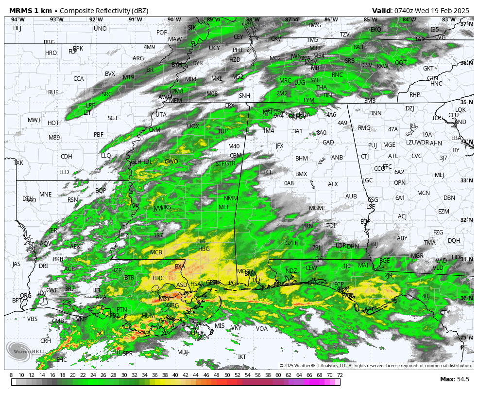
Radar check as of 1:43AM CST shows that rain has moved into the western portions of North and Central portions of the state, while South Alabama has been seeing rain for a little while at this point. The northwestern corner of the state, mainly from Red Bay to Huntsville and points northward, are seeing either a wintry mix or some light snowfall. Temperatures are currently in the lower 30s to the lower 50s from northwest to southeast across the state, with the only reading at 32 degrees at Courtland Airport in Lawrence County. Everyone else is above freezing. No travel issues have been reported so far. However, that may change as the cold front gets closer and move through the state later this morning and through the day, as most locations in North Alabama have already seen their high temperatures for the day. Temperatures will continue to fall through the morning and then stay chilly through the daylight hours. Any snowfall accumulations in the northern parts of the state should remain light, anywhere from a dusting to 1 inch, with some isolated spots receiving slightly more, up to around 2 inches of snowfall.
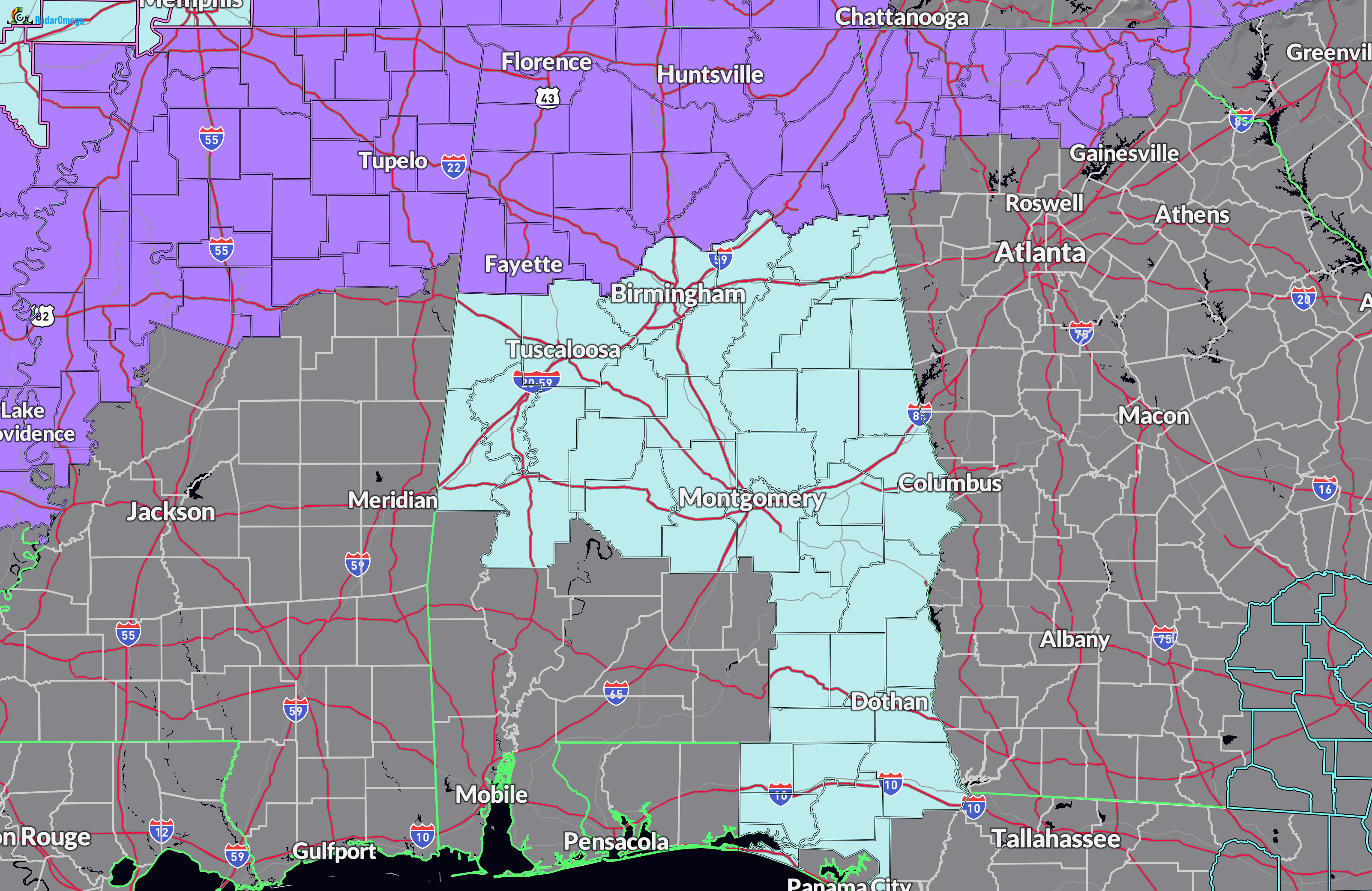
The latest on the watch/warning map shows that a Winter Weather Advisory continues in effect until 9PM CST tonight for Colbert, Cullman, DeKalb, Franklin, Jackson, Lauderdale, Lawrence, Limestone, Madison, Marshall, and Morgan counties in North Alabama, and for Blount, Cherokee, Etowah, Fayette, Lamar, Marion, Walker, and Winston counties in Central Alabama.
A Cold Weather Advisory continues until 12AM CST Thursday for Colbert, Cullman, DeKalb, Franklin, Jackson, Lauderdale, Lawrence, Limestone, Madison, Marshall, and Morgan counties in North Alabama, for Autauga, Barbour, Bibb, Blount, Bullock, Calhoun, Chambers, Cherokee, Chilton, Clay, Cleburne, Coosa, Dallas, Elmore, Etowah, Fayette, Greene, Hale, Jefferson, Lamar, Lee, Lowndes, Macon, Marengo, Marion, Montgomery, Perry, Pickens, Pike, Randolph, Russell, Shelby, St. Clair, Sumter, Talladega, Tallapoosa, Tuscaloosa, Walker, and Winston counties in Central Alabama. Coffee, Dale, Geneva, Henry, and Houston counties in southeast Alabama remain in the advisory until 4AM CST Thursday.
At this point, the south and southwestern portions of the state remain watch and advisory free.
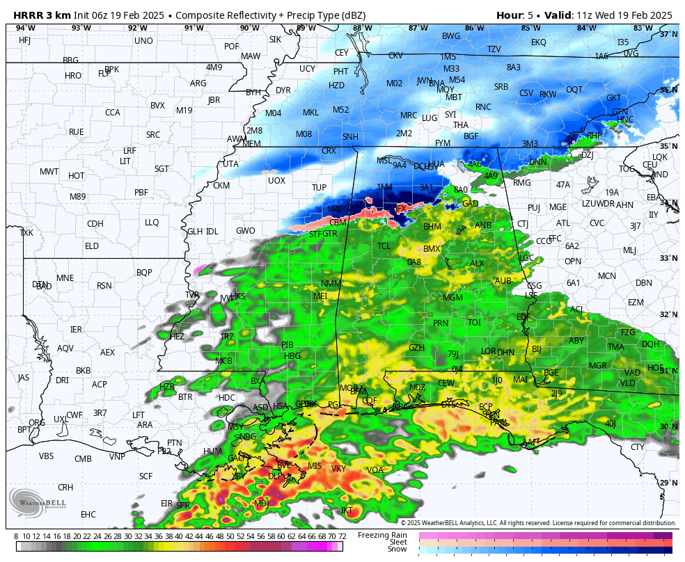
HRRR valid at 5AM CST this morning.
The latest model output from the HRRR shows that the heaviest snowfall and wintry mix will occur as we get closer to sunrise over the extreme northern and northwestern portions of Central Alabama and over the west and central parts of North Alabama. While temperatures have been close to and above freezing so far, it is around this time (4-5AM) that temperatures will dip below freezing, and we’ll really have to start to worry about slippery roads and dangerous travel conditions. Those temperatures will hover around the same numbers (28–34 degrees) throughout the rest of the morning hours at least until the noon hour. The good news is that the precipitation is modeled to come to a quick end over the northern third of the state, with nearly everyone along and north of I-59 dry by 8-9AM. A few flurries will be possible after that for those locations, while rain will start to end from west to east for the rest of the state.
For those getting rain this morning, the good news is that rainfall will be light to moderate in intensity across the area, with the heavier rain and storms remaining out over the gulf. A few claps of thunder will be possible this morning before sunrise for the southern half of the state, but the good news is that surface-based instability will remain over the open waters, and no severe weather is expected for the beaches of Alabama and up into the wire grass region of the state.
LATEST LIST OF CLOSINGS & DELAYS
Here is the list of closings and delays (as of 1:23AM CST) for schools and other organizations:
Albertville City Schools — 2-hour delay on Wednesday.
Athens Bible Schools — closed on Wednesday.
Athens City Schools — e-learning on Wednesday.
Athens State University — 3-hour delay on Wednesday.
Bethlehem Christian Academy in Hazel Green — closed on Wednesday.
Blount County Schools — e-learning on Wednesday, 2-hour delay on Thursday.
Boaz City Schools — 2-hour delay on Wednesday.
Calhoun Community College — e-learning on Wednesday.
Cherokee County Schools — 2-hour delay on Wednesday.
Cullman City Schools — 2-hour delay on Wednesday.
Cullman County Schools — 2-hour delay on Wednesday.
Decatur City Schools — closed on Wednesday.
Etowah County Schools — 2-hour delay on Wednesday.
Fayette County Schools — closed on Wednesday.
First Baptist Child Development Center (Madison) — closed on Wednesday.
Florence City Schools — closed on Wednesday.
Franklin County Schools — closed on Wednesday.
Gadsden City Schools — 2-hour delay on Wednesday.
Gadsden State Community College — 2-hour delay on Wednesday (employees report at 9:30AM).
Grace Lutheran School — closed on Wednesday.
Guntersville City Schools — 2-hour delay on Wednesday.
Haleyville City Schools — closed on Wednesday.
Hartselle City Schools — closed on Wednesday.
Huntsville City Hall — 2-hour delay on Wednesday.
Huntsville City Schools — closed on Wednesday.
Jackson County Schools — 2-hour delay on Wednesday.
Jasper City Schools — 2-hour delay on Wednesday.
Lawrence County Schools — closed on Wednesday.
Lifegate Academy — closed on Wednesday.
Limestone County Schools — e-learning on Wednesday.
Lincoln Academy — closed on Wednesday.
Lindsay Lane Christian Academy — closed on Wednesday.
Madison Academy — closed on Wednesday.
Madison City Schools — closed on Wednesday.
Madison County Schools — closed on Wednesday.
Marion County Schools — closed on Wednesday.
Mars Hill Bible School — e-learning on Wednesday, Preschool closed on Wednesday.
Marshall County Schools — 2-hour delay on Wednesday.
Marshall Space Flight Center — open at 10AM on Wednesday.
Morgan County Schools — closed on Wednesday.
Muscle Shoals City Schools — closed on Wednesday.
Northeast Alabama Community College — 2-hour delay on Wednesday.
Northwest-Shoals Community College — e-learning on Wednesday, campus operations closed.
Oneonta City Schools — closed on Wednesday, 2-hour delay on Thursday and Friday.
Pineview Christian Academy — closed on Wednesday.
Randolph School — closed on Wednesday.
Riverhill School — closed on Wednesday.
Russellville City Schools — closed on Wednesday.
Scottsboro City Schools — 2-hour delay on Wednesday.
Sheffield City Schools — closed on Wednesday.
St. John Paul II Catholic High School — e-learning on Wednesday.
Sumiton Christian School — 2-hour delay on Wednesday.
Tuscumbia City Schools — closed on Wednesday.
U.S. Space & Rocket Center — open at 10AM on Wednesday.
University of Alabama-Huntsville — e-learning on Wednesday.
Valley Fellowship Christian Academy — closed on Wednesday.
Walker County Schools — 2-hour delay on Wednesday.
Wallace State Community College — 2-hour delay on Wednesday.
Westbrook Christian School — 2-hour delay on Wednesday.
Westminster Christian Academy (Lower) — closed on Wednesday.
Westminster Christian Academy (Upper) — closed on Wednesday.
Winfield City Schools — closed on Wednesday.
Winston County Schools — e-learning on Wednesday.
Category: Alabama's Weather, ALL POSTS, Social Media, Winter Weather
About the Author (Author Profile)
Scott Martin is an operational meteorologist, professional graphic artist, musician, husband, and father. Not only is Scott a member of the National Weather Association, but he is also the Central Alabama Chapter of the NWA president. Scott is also the co-founder of Racecast Weather, which provides forecasts for many racing series across the USA. He also supplies forecasts for the BassMaster Elite Series events including the BassMaster Classic.Subscribe
If you enjoyed this article, subscribe to receive more just like it.


