Sunday Weather Briefing Video: Rain South, Dry North, Warmer Week Ahead
WINTER’S FINAL STAND? A RAINY SOUTH, A DRY NORTH, AND A WARMING TREND AHEAD
As February winds down, we’re watching the battle between lingering winter chill and the first hints of spring. While southern Alabama sees a wet Sunday, drier conditions persist up north. A warming trend kicks in this week, with temperatures climbing well above seasonal averages by midweek. Meanwhile, a series of weak systems will keep light rain chances in play for parts of the state, but no major storms are expected.
SYNOPSIS OF CURRENT WEATHER MAP: GULF LOW BRINGS RAIN TO THE SOUTH
A developing coastal low near the Texas Gulf Coast will move eastward today, spreading light to moderate rainfall across the southern half of Alabama. Meanwhile, high pressure remains in control across North Alabama, keeping conditions dry but cool. A series of weak Clipper systems will bring light snow to the Great Lakes and Northeast this week, while the central U.S. enjoys above-normal temperatures.
FOR SUNDAY: RAIN HOLDS SOUTH, DRY NORTH
Clouds will increase from south to north, with rain developing over the southern half of Alabama this afternoon and evening. The best rain chances will be south of I-22 and US-280, while North Alabama stays dry. Rain totals will range from a trace to ½ inch for most, with up to 1 inch along the Gulf Coast. Highs will be in the lower 50s in the north, rising to the lower 60s in the south.
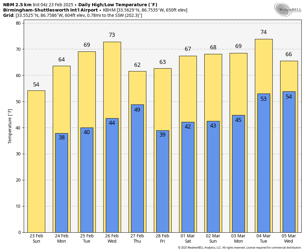
FIRST PART OF THE WORK WEEK: A WARMING TREND BEGINS
Monday starts chilly but dry, with any lingering rain clearing out by noon. Temperatures climb steadily, reaching the upper 50s to upper 60s Monday afternoon. By Tuesday, highs rise into the mid-60s to lower 70s, with plenty of sunshine and dry conditions.
MIDWEEK: WARMER TEMPS, A FEW SHOWERS
By Wednesday, warm air surges in, pushing highs into the upper 60s to upper 70s across the state. A weak cold front moves in Wednesday night into Thursday, bringing a slight chance for rain in North Alabama. However, rainfall amounts will be light (under 0.10 inches), and no severe weather is expected.
LATER IN THE WEEK: SLIGHTLY COOLER, BUT STILL ABOVE NORMAL
After the front moves through, Thursday and Friday will be slightly cooler, with highs in the upper 50s to lower 70s on Thursday and upper 50s to upper 60s on Friday. Dry conditions will prevail, with sunny to partly cloudy skies.
WEEKEND OUTLOOK: DRY SATURDAY, RAIN POSSIBLE SUNDAY
The first half of next weekend looks dry and seasonable, with highs in the 60s on Saturday. However, another weak system could bring rain chances back into the picture by Sunday, especially for southern Alabama.
WEEK TWO SNEAK PEEK: NO MAJOR COLD BLASTS IN SIGHT
Looking into early March, the pattern remains mild, with above-average temperatures likely across the Deep South. No major cold outbreaks or winter storms are expected at this time.
BEACH FORECAST: COOLER TEMPS, SHOWERS SUNDAY, THEN A WARMING TREND
If you’re headed to the Gulf Coast, expect a cloudy and cool Sunday with showers developing, especially in the afternoon and evening. Highs will be in the mid to upper 50s, with northeast winds around 10 mph. Water temperatures remain in the upper 50s. The rain clears out by Monday, and sunshine returns with a warming trend through midweek. Highs will reach the lower 60s on Monday, mid-60s Tuesday, and upper 60s by Wednesday. Surf heights will be around 1 foot on Sunday, increasing to 2-3 feet early next week. Rip current risks remain low through Sunday but increase to moderate levels by Monday and Tuesday. No major storms or hazardous conditions are expected.
NATIONAL WEATHER: A PARADE OF CLIPPERS, STORMY NORTHWEST
A series of Clipper systems will bring light snow to the Great Lakes and Northeast throughout the week, with each system producing between one to two inches of accumulation. These quick-moving disturbances will arrive on Monday and Tuesday, followed by another midweek and continuing into next weekend. Meanwhile, the central U.S. will experience mild and dry conditions, with temperatures running above seasonal averages. In contrast, the Pacific Northwest will remain stormy, with frequent rounds of rain and mountain snow persisting through the week.
WEATHERBRAINS UPCOMING GUEST: ROGER EDWARDS ON FORECASTING & GOVERNMENT CUTBACKS
This week on WeatherBrains, we’ll be joined by Roger Edwards, a retired lead forecaster from the Storm Prediction Center (SPC). He’ll share insights from his nearly 40 years in severe weather forecasting, discuss the evolution of tornado prediction, and weigh in on how government cutbacks could impact severe weather forecasting and public safety efforts at NOAA and SPC.
TODAY IN WEATHER HISTORY: FEBRUARY 23, 1975 – DEADLY TORNADO STRIKES TUSCALOOSA
On this day in 1975, an F4 tornado struck Tuscaloosa just before 3 p.m. CST, becoming the deadliest tornado in Alabama that year. It first touched down in Taylorville and moved northeast, hitting Skyland Park, the McFarland Boulevard exit on I-59/20, and parts of Alberta City and Holt. The tornado destroyed or heavily damaged 289 homes, 20 businesses, and 21 mobile homes along its 14.4-mile path. The worst damage occurred at the Scottish Inn motel near I-59, where a 23-year-old housekeeper, Thelma Hill, was killed when part of the second floor collapsed. The storm was part of a larger outbreak that produced four tornadoes across Walker, Cullman, and Calhoun counties, fueled by a strong low-pressure system, high humidity, and backed southeasterly winds.
Category: Alabama's Weather, ALL POSTS, Social Media, Winter Weather
About the Author (Author Profile)
Bill Murray is the President of The Weather Factory. He is the site's official weather historian and a weekend forecaster. He also anchors the site's severe weather coverage. Bill Murray is the proud holder of National Weather Association Digital Seal #0001 @wxhistorianSubscribe
If you enjoyed this article, subscribe to receive more just like it.


