Midday Nowcast: Increasing Winds Ahead of Strong Storms Arriving Later Today
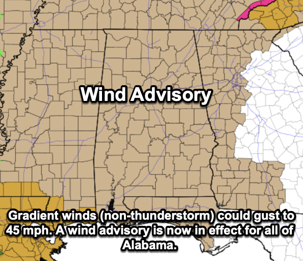
WINDY DAY: A deepening surface low will cause a tight pressure gradient across the state causing our winds to increase today. Wind fields will be impressive with the tight pressure gradient. Ahead of the line, gradient winds (non-thunderstorm) could gust to 45 mph. A wind advisory is now in effect for all of Alabama.
STORMS ON THE WAY: Tonight, an organized band of showers and thunderstorms will move into Alabama. The Storm Prediction Center (SPC) maintains an “enhanced risk” (level 3/5) of severe thunderstorms across Southwest Alabama… most of the rest of the state it in a “slight risk” (level 2/5).
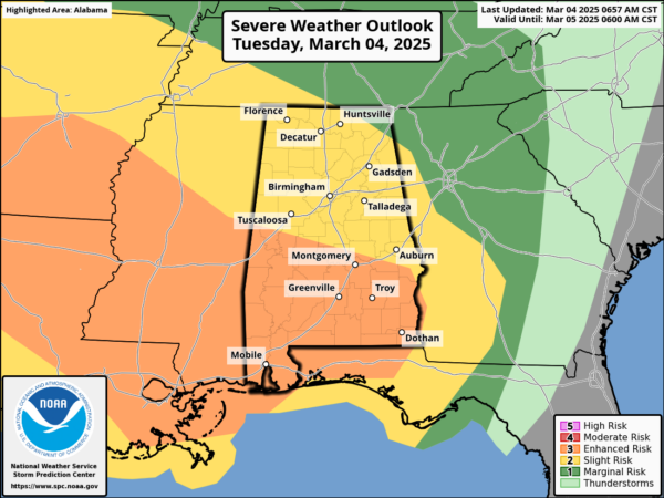
There will be very little surface based instability ahead of the line, which will limit the overall magnitude of the event. A brief, isolated tornado or two is possible within the line, but isn’t especially likely for most of Alabama. However, some unstable air could very well make it into Southwest Alabama, where SPC has defined the “enhanced risk”. There is a higher tornado threat in these area. The main concern will be damaging winds within the line, which are certainly capable of bringing down trees and causing power issues. Secure any loose objects (like trampolines, outdoor furniture, and garbage cans) that might go flying this evening.
The storms should enter the northwest corner of Alabama around 6-7PM CT, and exit the southeast corner by 1-2AM CT. Showers will likely break out ahead of the line late this afternoon across West Alabama.
This will be a fast moving line of storms; rain amounts will be around 1/2 inch for most places. Flooding issues are not expected.
BIRMINGHAM ALMANAC: For March 4th, the average high for Birmingham is 64° and the average low is 43°. The record high is 84° set in 1976, while the record low is 17° set in 1943. We average 0.19” of precipitation on this date and the record value is 2.24” set in 1945.
REST OF THIS WEEK: Look for a partly sunny sky tomorrow with a highs in close to 60°; a few scattered showers are possible over the northern third of the state by afternoon with moisture wrapping around the deep surface low to the north. Temperatures will drop to near the freezing mark over North Alabama early Thursday morning… followed by a high in the mid to upper 50s with sunshine in full supply. Friday will be a sunny, warmer day with a high in the upper 60s and low 70s.
THE ALABAMA WEEKEND: A fast moving disturbance will bring some rain to the state over the weekend; for now it looks like the best chance will come Saturday night into Sunday morning. Severe storms are not expected, and highs will be mostly in the 60s. Most of next week looks dry and mild.
WORLD TEMPERATURE EXTREMES: Over the last 24 hours, the highest observation outside the U.S. was 119.7F at Glen College, South Africa. The lowest observation was -76.5F at Vostok, Antarctica.
CONTIGUOUS TEMPERATURE EXTREMES: Over the last 24 hours, the highest observation was 98F at Rio Grande Village, TX. The lowest observation was -16F at Masardis, ME.
Category: Alabama's Weather, ALL POSTS, Severe Weather, Social Media
About the Author (Author Profile)
Macon, Georgia Television Chief Meteorologist, Birmingham native, and long time Contributor on AlabamaWX. Stormchaser. I did not choose Weather, it chose Me. College Football Fanatic. @Ryan_StinnetSubscribe
If you enjoyed this article, subscribe to receive more just like it.


