A Check on the Alabama Severe Weather Situation at Noon
RADAR CHECK JUST AFTER NOON
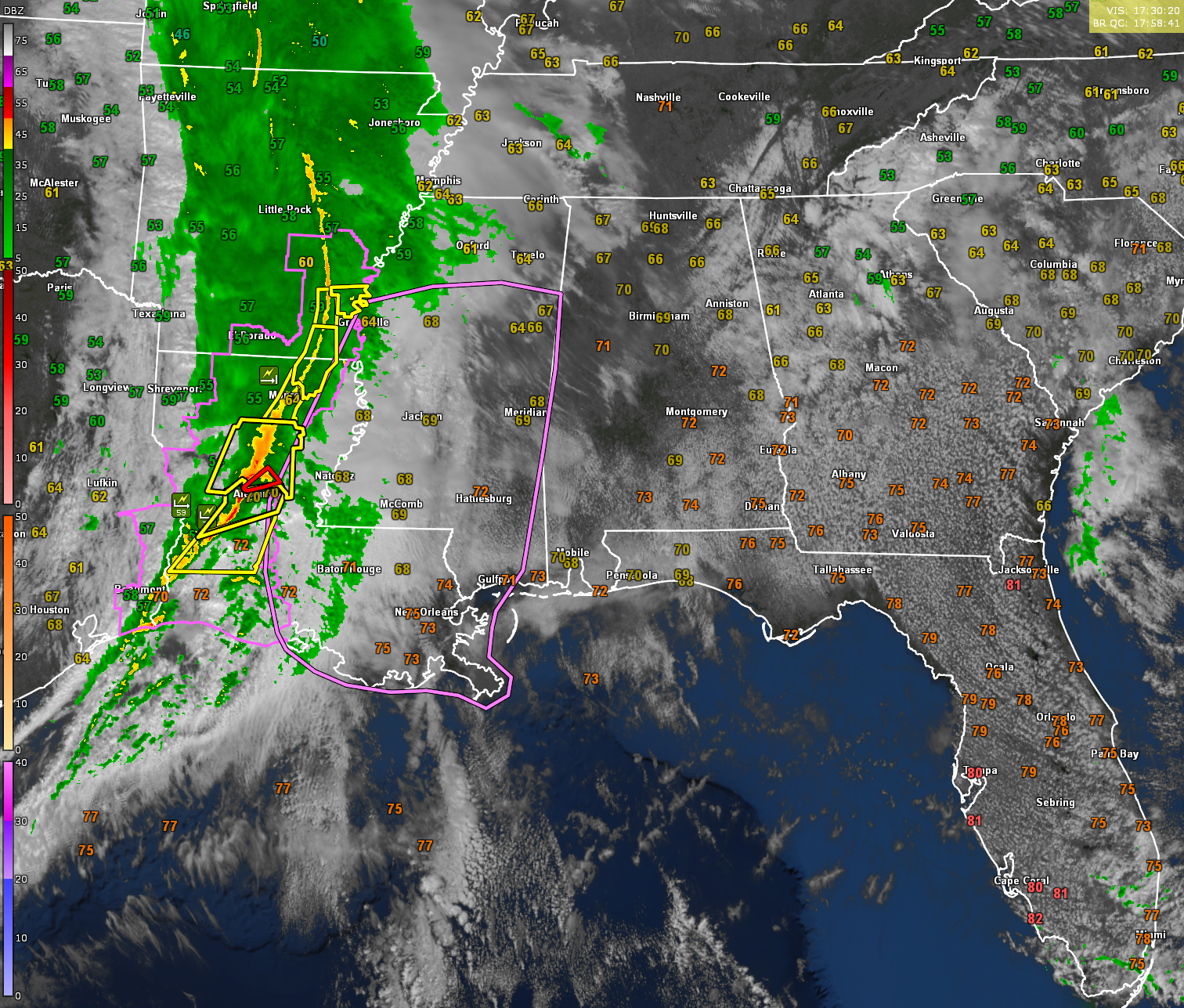
Our squall line extends from southern Arkansas into Central and Southwest Louisiana just after the noon hour. Severe thunderstorm warnings extend from Monticello, AR to near Monroe, LA to near Leesville and Alexandria, LA to near DeQuincy, LA. A confirmed tornado was approaching Alexandria, LA at about 30 mins ago, but the storm has since weakened. A new tornado warning covers the area around Pollock, which is north of Alexandria. Winds at AEX are gusting to 45 mph out of the south southeast.
ALABAMA CONDITIONS
There is some clearing underway across Alabama at this hour with a decent inversion in place at about 10,000 feet. Temperatures are warming into the upper 60s and lower 70s. Dew points are climbing through the upper 40s and lower 50s. Winds are gusting to 42 mph at Huntsville International, 25 mph at Birmingham, and 35 mph at Greenville in Butler County.
WINDY CONDITIONS AHEAD OF STORMS
Alabama remains under a Wind Advisory through Wednesday afternoon as a deepening surface low strengthens the pressure gradient over the region. Winds outside of thunderstorms are already gusting 30-40 mph, with gusts up to 45 mph possible later today. These winds can bring down tree limbs and power lines even before storms arrive, so securing loose objects outside is advised.
TORNADO WATCH SOON FOR MISSISSIPPI AND SOUTHEAST LOUISIANA
The Storm Prediction Center just said that they will be issuing a tornado watch soon for the southern two thirds of Mississippi and much of southeastern Louisiana. Low to mid-60s dewpoints are surging inland, leading to rapid destabilization. A measured 61-knot wind gust has already been recorded at KPOE, emphasizing the strength of this system. Areas south of I-20 in Mississippi will experience the highest instability, increasing the risk for embedded tornadoes within the line of storms. The HRRR model continues to indicate the potential for discrete supercells ahead of the main squall line, particularly in southern Mississippi and eastern Louisiana. These supercells, if they develop, could produce strong tornadoes in addition to the severe wind threat within the squall line. Regardless of whether supercells form independently, the strong kinematic environment will continue to support QLCS tornadoes within the advancing storm line.
Our fast-moving line of storms will enter northwest Alabama between 6-7 PM, sweeping quickly across the state and exiting southeast Alabama by 1-2 AM. The primary threat is damaging straight-line winds, but a few isolated tornadoes remain possible, particularly in Southwest Alabama where SPC has issued an Enhanced Risk (level 3/5). There is a danger of more significant tornadoes over southwestern Alabama, south of a line from Livingston to Linden to Beatrice to Evergreen. The storms will move rapidly, limiting rainfall totals to 0.5 to 1 inch, with no major flooding concerns expected.
LOW INSTABILITY, BUT HIGH WIND SHEAR
While instability is limited for most of the state, strong wind shear will support embedded tornadoes within the line and the potential for a few stronger storms to develop, especially in the southwest portion of the state. Wind gusts within the squall line could exceed 60 mph, leading to power outages and downed trees.
STAY WEATHER-AWARE TONIGHT
Given the overnight timing, residents should have multiple ways to receive warnings, including NOAA Weather Radio, Wireless Emergency Alerts (WEA), the AlabamaWX Blog and of course the crew at ABC3340 including Alabama’s Chief Meteorologist, James Spann. Charge electronic devices in case of power outages, and have a severe weather plan ready, especially if you live in manufactured housing or a weaker structure.
Category: Alabama's Weather, ALL POSTS, Severe Weather, Social Media
About the Author (Author Profile)
Bill Murray is the President of The Weather Factory. He is the site's official weather historian and a weekend forecaster. He also anchors the site's severe weather coverage. Bill Murray is the proud holder of National Weather Association Digital Seal #0001 @wxhistorianSubscribe
If you enjoyed this article, subscribe to receive more just like it.


