Active Weather Starting Today; Severe Storm Threat Continues on Late Sunday Through Monday
TODAY’S WEATHER: A few showers are showing up on radar early this morning, but with dry air in place, most of it likely isn’t reaching the ground. As moisture increases through the day, rain will start making it to the surface, with coverage increasing into the afternoon. A few thunderstorms are possible this afternoon, but with instability and shear staying rather low, severe weather isn’t expected. Rainfall amounts should stay under half an inch for most, though some areas in northwestern Alabama could see a bit more. Those clouds and rain chances will keep temperatures slightly cooler in the northwest, but highs will still reach the mid to upper 70s.
SEVERE STORMS POSSIBLE SUNDAY NIGHT THROUGH MONDAY: A strong weather system will move across the Midwest and Mississippi Valley, bringing the potential for severe storms. A cold front will trigger storms to our northwest during the afternoon, with large hail, damaging winds, and a few tornadoes possible. These storms could form into organized lines, increasing the risk for strong winds and embedded tornadoes as they move eastward overnight.
For the southeast, the forecast is less certain due to questions about cloud cover and early rain. If enough instability develops, storms in the Lower Mississippi Valley and Tennessee Valley could become severe, with a threat of very large hail, damaging winds, and possibly strong tornadoes. Some models suggest lingering showers may limit the severe threat, but that may be an outlier for now. However, a higher risk could be needed in future updates if conditions become more favorable for dangerous storms. These risks will continue through a good portion of Monday in the Southeast, continuing the threat of tornadoes, damaging winds, and large hail. Stay weather-aware and keep an eye on updates.
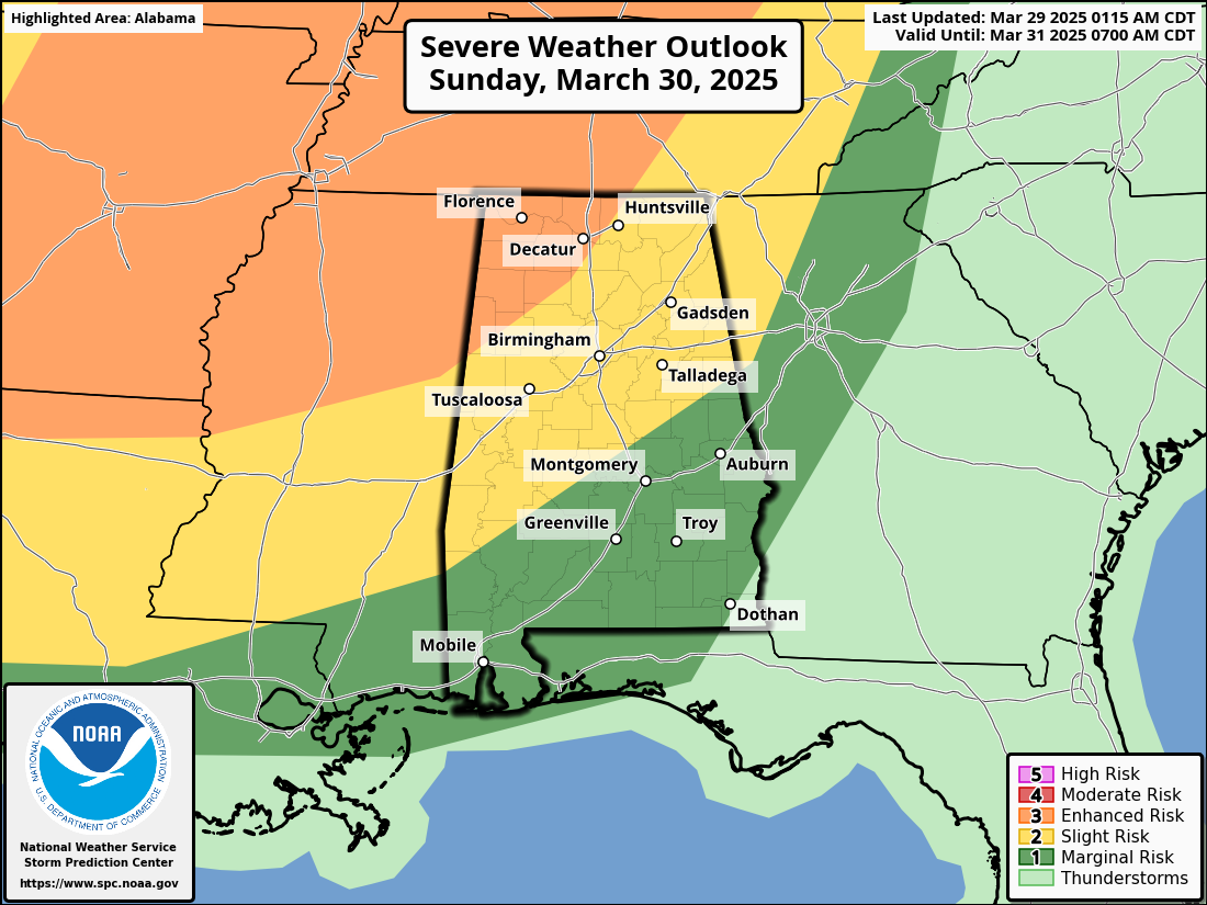
The Storm Prediction Center has an Enhanced Risk of severe storms (level 3 of 5) up for the northwest corner of the state, with a Slight Risk (level 2 of 5) up south and east of that to the east-central to the southwestern parts of the state, and a Marginal Risk up for the rest of the state on Sunday. These risks are for late Sunday until 7AM CDT Monday morning.
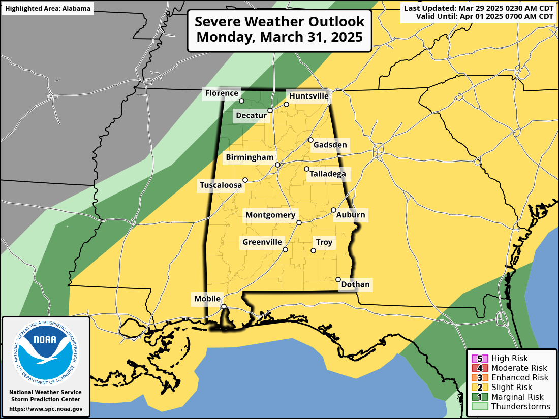
That severe risk carries over through the day on Monday, with much of the state in a Slight risk for severe storms except for the northwest corner of the state, where a Marginal Risk is up. These risks go through the day on Monday after 7AM.
All modes of severe weather will be possible, which includes tornadoes, damaging winds, and large hail. The main window for severe weather will start at early as 10PM Sunday night in the northwest corner of the state and slowly moving southeastward with the threat reaching the central parts of the state by 4AM Monday morning, and making it into the southeastern parts of the state around 8AM and exiting by 3PM.
A BREAK IN BETWEEN SYSTEMS: Tuesday looks to be a quiet day that will be stuck in between the departing storms from Monday and another approaching system on Wednesday. Temperatures will stay mild to warm after the frontal passage, reaching the lower 70s to the lower 80s. Much of the day will be mostly sunny, but clouds will be on the increase late with the approach of the next potential severe weather threat for parts of the state.
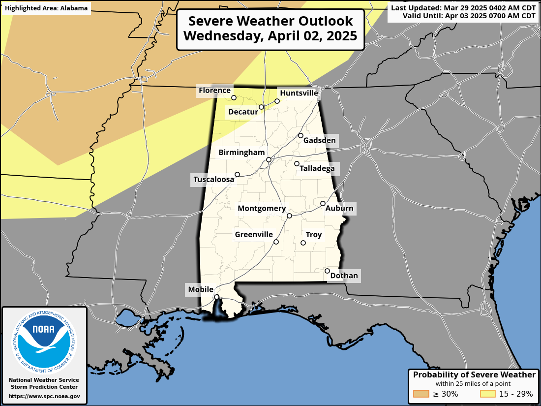
MORE SEVERE STORMS POSSIBLE LATE WEDNESDAY INTO EARLY THURSDAY: As we head into the second half of the week, a strong weather pattern will set up. A ridge near Florida will pump in some serious warmer weather, with temperatures approaching record highs. But before that really takes over, we’ve got a storm system to watch on Wednesday. A cold front will stall just northwest of Alabama Wednesday night, and right now, it’s unclear if storms will make it into our area. But if they do, they could pack a punch with the potential for all types of severe weather. The setup isn’t a slam dunk for storms, but it’s something we’ll be watching closely. For now, SPC has a Slight Risk for severe storms up for the northwestern parts of the state. Highs in the upper 70s to the mid 80s.
ACTIVE WEATHER TO FINISH OUT THE WORK WEEK: With a stalled front hanging out to our northwest and disturbances rotating around the ridge, we’ll need to keep an eye on Thursday and Friday for any thunderstorms that could sneak into our area. If they do, they might temporarily weaken the ridge, and with plenty of heat and instability around, storms could turn strong. It’s not a guarantee, but it’s something to watch as we head into the end of the week. Thursday’s highs in the lower 80s to near 90 degrees, with Friday’s highs reaching the same levels.
Category: Alabama's Weather, ALL POSTS, Severe Weather, Social Media, Weather Xtreme Videos
About the Author (Author Profile)
Scott Martin is an operational meteorologist, professional graphic artist, musician, husband, and father. Not only is Scott a member of the National Weather Association, but he is also the Central Alabama Chapter of the NWA president. Scott is also the co-founder of Racecast Weather, which provides forecasts for many racing series across the USA. He also supplies forecasts for the BassMaster Elite Series events including the BassMaster Classic.Subscribe
If you enjoyed this article, subscribe to receive more just like it.


