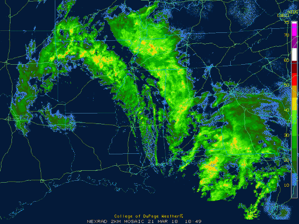
Early Morning Update
After a nice first official day of spring across Central Alabama, things are changing.
A cold front is pushing trough Mississippi at this hour, trailing from a low near Memphis. It was 56F at Meridian and 40F at Jackson. It was 35F at Shreveport and 32F at Dallas with moderate snow. Moderate snow covers parts of northern Texas, much of eastern Arkansas, western Arkansas down into northwestern Louisiana at this hour.
3-6 inches of snow is the snow total expectation for areas east of I-30 and north of I-35 in Northeast Texas. Five inches already on the ground at Plano. Sanding roads in the Sherman areas. Slush on overpasses with about three inches in McKinney. That area has been upgraded to a winter storm warning in the past few minutes.
Winter storm warnings cover eastern Oklahoma up into Northwestern Arkansas and parts of Missouri and Nebraska.
Ahead of the front, showers are pushing across West Alabama back into Central Mississippi.
The rain has reached the Birmingham metro are, extending up to Florence then back down through West Alabama near Gordo and Reform on southward to near Demopolis.
The heaviest rain was near Fayette.
No lightning being reported by the detection networks, even though some thunder is not out of the question.
Behind the primary band of precipitation, another swath of showers was over Central Mississippi. It is associated with the big upper level low that is over southwestern Arkansas.
As the big upper low moves toward us, it will continue our chance for showers through Monday evening. There is a chance that there could be a few snow flakes mixed in late tonight through late morning Monday. No accumulation is expected thanks to the warm ground temperatures.
With the very cold air aloft, we could also see some reports of something like small hail, but it’s not really hail. Small ice pellets called graupel can form with the upward motion in the instability caused by the cold air aloft. So don’t be surprised if you hear about some really big sleet or small hail. Just look at your friends and say, “that’s graupel.”
Brian will be along with the morning discussion shortly. We will keep an eye on reports to the west through the day. Stay dry and dress warmly for the temperatures that will be slowly falling during the day. No more 70s for us until Wednesday.
Category: Uncategorized


