Quick Update at 6:20 pm
A significant severe weather event is underway this evening across parts of the Mid-South, Lower Mississippi Valley, and Ohio Valley. A high risk remains in effect for eastern Arkansas, northwest Mississippi, western Tennessee, and the lower Ohio Valley — including parts of southeastern Missouri, southern Illinois, and western Kentucky — where numerous tornadoes, including strong to violent (EF3+) long-track tornadoes, damaging winds, and very large hail are possible.
21 tornado warnings are in effect right now including 2 confirmed tornado warnings in Arkansas.
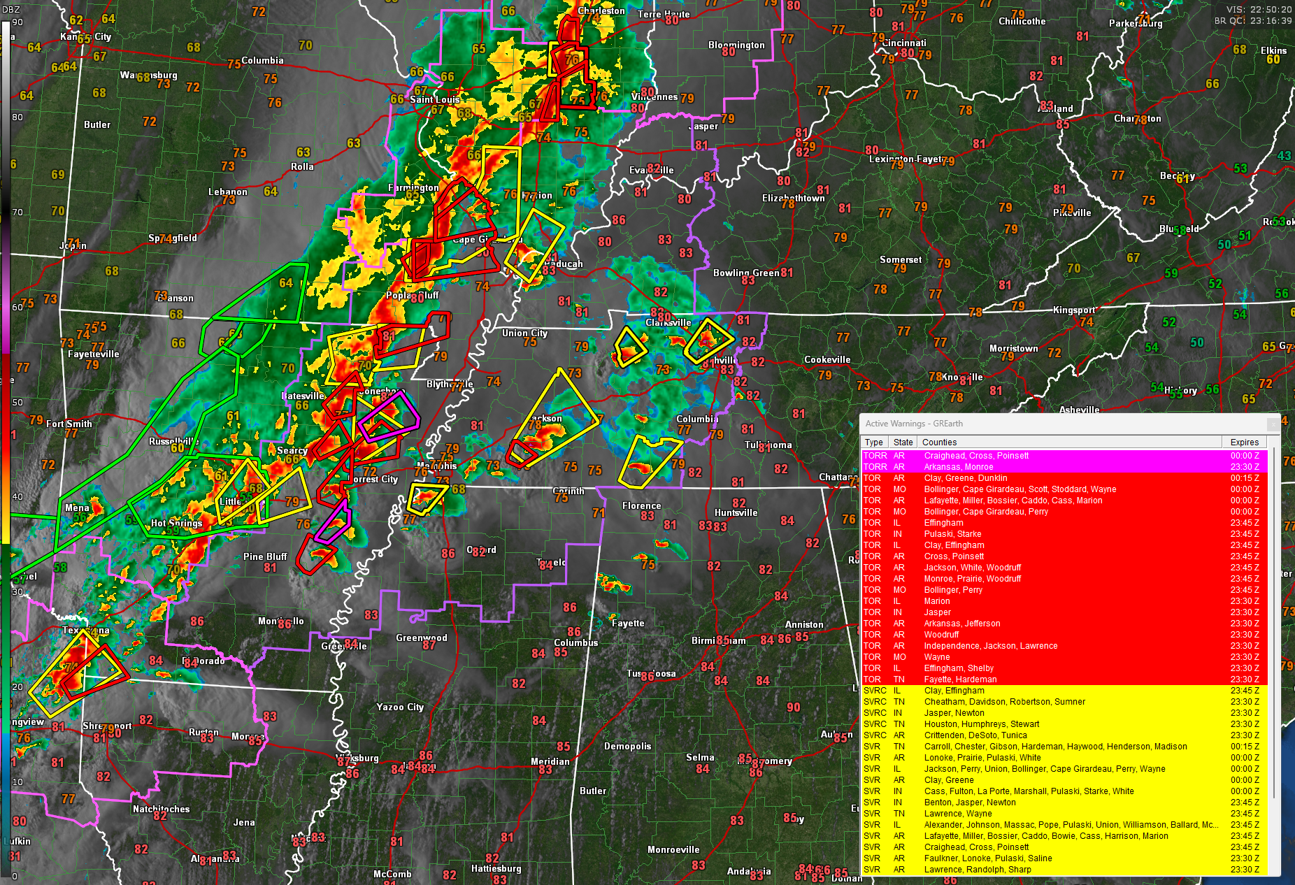
A corridor of intense tornado potential continues across northern Mississippi and western Tennessee, where the environment remains highly supportive of strong to violent tornadoes. Low-level wind shear is high, and storms are moving into a more unstable and favorable air mass.
New development has begun to extend into middle Tennessee and central Kentucky this evening. A clustering of storms is forming in response to increasing low-level warm advection and a possible weak disturbance aloft. These storms could organize and intensify through the evening hours…
…damaging wind gusts
…large hail
…tornadoes, possibly strong
Confidence is growing that storms will track northeast through middle Tennessee into central Kentucky between 9 and 11 PM EDT. A watch may be issued soon as low-level flow increases dramatically with 850 mb winds reaching 50 to 70+ knots. The main limiting factor remains convective inhibition, which may build with diurnal cooling… but if storms hold, the severe threat could intensify.
The current watch that includes western Tennessee has already been extended into the Nashville area.
In Alabama, the severe threat remains conditional this evening. A few isolated supercell storms have worked their way into or formed across northwest Alabama. This will continue for the next couple of hours in a highly unstable environment…
…SBCAPE 2500-3000 J/kg
…bulk shear 40-50 kt
Windy conditions continue across Alabama with gusts up to 40 mph possible, especially north and central. Overnight, strong storms from Mississippi may reach far northwest Alabama during the early morning hours Thursday. Winds actually gusted to 40 mph at the Birmingham Airport this afternoon.
Category: Alabama's Weather, ALL POSTS, Severe Weather, Social Media
About the Author (Author Profile)
Bill Murray is the President of The Weather Factory. He is the site's official weather historian and a weekend forecaster. He also anchors the site's severe weather coverage. Bill Murray is the proud holder of National Weather Association Digital Seal #0001 @wxhistorianSubscribe
If you enjoyed this article, subscribe to receive more just like it.


