CANCELED Tornado Warning for Parts of Autauga, Lowndes, and Dallas Counties
UPDATE AT 10:29
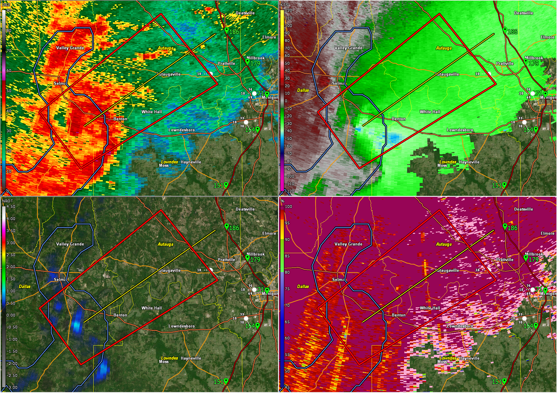
According to Gerald Satterwhite at the NWS Birmingham, a brief tornado debris signature may have occurred on the south side of highway 80. The circulation has since dissipated and the warning has been canceled.
A small area of rotation near Sardis in southeast Dallas County is moving toward Highway 80. It will probably be short lived but take cover now if you are in the polygon.
BULLETIN – EAS ACTIVATION REQUESTED
Tornado Warning
National Weather Service Birmingham AL
1012 AM CDT Sun Apr 6 2025
The National Weather Service in Birmingham has issued a
* Tornado Warning for…
Central Autauga County in central Alabama…
Northwestern Lowndes County in south central Alabama…
Southeastern Dallas County in south central Alabama…
* Until 1045 AM CDT.
* At 1012 AM CDT, a severe thunderstorm capable of producing a
tornado was located near Tyler, or 7 miles southeast of
Selmont-West Selmont, moving northeast at 60 mph.
HAZARD…Tornado.
SOURCE…Radar indicated rotation.
IMPACT…Flying debris will be dangerous to those caught without
shelter. Mobile homes will be damaged or destroyed.
Damage to roofs, windows, and vehicles will occur. Tree
damage is likely.
* Locations impacted include…
Selma Drag Strip, Mulberry, Vida Junction, Autaugaville, Gardner
Island, Robert F. Henry Lock And Dam, Benton, Tyler, Selmont-West
Selmont, White Hall, and Craig Field Aiport.
PRECAUTIONARY/PREPAREDNESS ACTIONS…
TAKE COVER NOW! Move to a basement or an interior room on the lowest
floor of a sturdy building. Avoid windows. If you are outdoors, in a
mobile home, or in a vehicle, move to the closest substantial shelter
and protect yourself from flying debris.
Category: Alabama's Weather, ALL POSTS, Severe Weather, Social Media
About the Author (Author Profile)
Bill Murray is the President of The Weather Factory. He is the site's official weather historian and a weekend forecaster. He also anchors the site's severe weather coverage. Bill Murray is the proud holder of National Weather Association Digital Seal #0001 @wxhistorianSubscribe
If you enjoyed this article, subscribe to receive more just like it.


