Stormy Skies Over Central Alabama
SIGNIFICANT WEATHER ADVISORY FOR THE BIRMINGHAM METRO
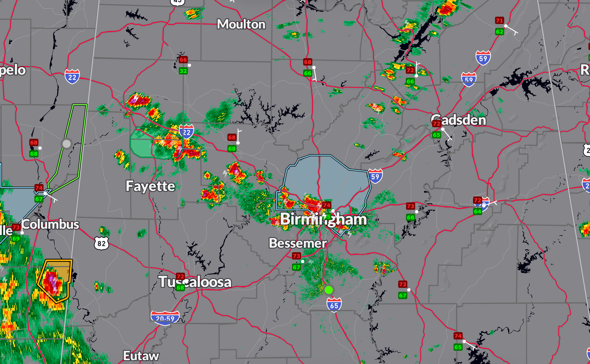
A strong thunderstorm is currently impacting northeastern Jefferson County, including parts of the Birmingham metro area. It will continue to produce gusty winds, small hail, and frequent cloud-to-ground lightning. There may be a downed tree or two with this activity. Monitoring for any more significant risk. The storm, located along a line from West Jefferson to Irondale is moving north at 10 mph. Torrential rainfall ais occurring with these storms, which may lead to localized flooding. Residents in Mountain Brook, Pinson, Gardendale, and surrounding communities should stay indoors until the storm passes around 3:30 PM.
The cluster of cells moving northward across Jefferson County
SEVERE THUNDERSTORM WARNING JUST ACROSS THE MISSISSIPPI BORDER
Meanwhile, the National Weather Service in Jackson has issued a severe thunderstorm warning for northeastern Noxubee and south-central Lowndes counties in eastern Mississippi. A storm near Prairie Point is moving northeast at 15 mph and may produce quarter-sized hail and damaging winds up to 60 mph. This storm could cause damage to roofs, trees, and vehicles. Residents near Bigbee Valley should seek shelter immediately in an interior room away from windows.
CURRENT WEATHER SITUATION
Scattered showers and isolated thunderstorms continue across central Alabama this afternoon under a west-southwest flow aloft and an approaching longwave trough. The atmosphere remains moist and moderately unstable, especially over western counties, supporting continued storm development through the late afternoon and evening. Temperatures are ranging from the upper 70s to mid-80s depending on cloud cover, and additional isolated storms are expected tonight, primarily across the western half of the state.
Category: Alabama's Weather, ALL POSTS, Severe Weather, Social Media
About the Author (Author Profile)
Bill Murray is the President of The Weather Factory. He is the site's official weather historian and a weekend forecaster. He also anchors the site's severe weather coverage. Bill Murray is the proud holder of National Weather Association Digital Seal #0001 @wxhistorianSubscribe
If you enjoyed this article, subscribe to receive more just like it.


