Sunday Weather Briefing: April To End On A Warm And Quiet Note
NO VIDEO TODAY DUE TO TRAVEL DEMANDS
It’s a classic late April weekend across Alabama, with busy outdoor events filling the calendar like the Jack Link’s 500 at Talladega and the Magic City Art Connection at Sloss Furnaces. Warm air, a returning front, and a mix of sun and scattered storms are all on the menu as we wrap up the month. Even with a few showers around, it feels unmistakably like the transition from spring to summer, where blue-sky days give way to building clouds and a hint of thunder in the afternoon. By the time we reach next weekend, big changes could be lurking on the horizon.
A WEAK FRONT AND SOME SHOWERS TODAY
Today’s weather is shaped by a weak cold front that slipped south overnight and will begin lifting back northward later today. Morning sun will gradually give way to increasing clouds, especially across southern and western sections. Scattered showers and a few thunderstorms will be most likely along and south of U.S. Highway 80, but coverage will stay isolated northeast of Birmingham and Gadsden. Winds will be light from the north, with afternoon highs ranging from near 80 in the north to the upper 80s across the southern counties. A beautiful start for early festivities, but keep an eye out for a pop-up shower by mid-to-late afternoon at events like the Magic City Art Connection and at Talladega.
QUIET NIGHT AHEAD
The shower activity will diminish after sunset, with partly cloudy skies overnight. It will be mild and comfortable for Sunday evening plans, with lows dipping into the upper 50s across north Alabama and into the lower to mid 60s farther south. Winds will stay light and variable, and the atmosphere will reload for another warm day on Monday.
A WARM, MOSTLY DRY START TO THE WORK WEEK
Monday through Wednesday will feature mainly dry and very warm conditions. High pressure will settle off the Atlantic coast, funneling in a southwest flow that will keep temperatures climbing into the upper 80s to near 90 degrees each afternoon. A few showers or storms could pop up along a “backdoor” front near east Alabama Monday afternoon, but rain chances remain very low overall. Humidity levels will also start to rise slightly midweek, giving things a bit more of a summerlike feel.
RAIN RETURNS LATE WEEK, THEN A BIG CHANGE
By Thursday, a strong upper trough will approach from the Plains, breaking down the ridge and introducing higher rain chances. Showers and thunderstorms are expected Thursday afternoon and especially Friday as a cold front moves through. Some storms could be strong, and Friday could be a rather wet day for the end of the work week. By next weekend, much cooler air could pour in, with highs dropping back into the 60s North and 70s Central and lows into the 40s and lower 50s—a real shot of early May coolness.
VOODOO TERRITORY: COOLER SPELL IN EARLY MAY
The first full week of May looks to stay unsettled with additional rounds of showers and storms possible. Around May 9th–10th, a strong push of much cooler air could sweep in, dropping daytime highs into the 50s and 60s and bringing overnight lows back into the 40s. Don’t pack away the light jackets just yet!
SEVERE WEATHER OUTLOOK FOR SUNDAY
The Storm Prediction Center highlights a Slight Risk (level 2/5) for severe storms Sunday across parts of the northern and central Plains. Large hail will be the main threat, with the potential for a few strong storms late in the day and into Sunday night.
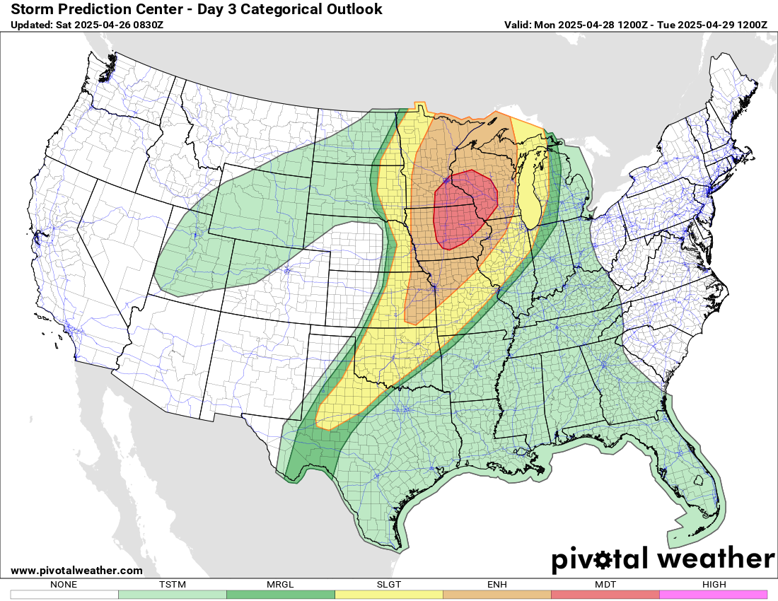
TORNADO OUTBREAK POSSIBLE MONDAY ACROSS UPPER MIDWEST
A significant severe weather outbreak is expected Monday across parts of the Upper Midwest, particularly central and eastern Iowa, southeast Minnesota, and western Wisconsin. The Storm Prediction Center has issued a Moderate Risk (level 4/5) for this region, highlighting the potential for widespread severe thunderstorms capable of producing very large hail, destructive winds, and strong, long-track tornadoes. Atmospheric conditions will be highly favorable, with intense wind shear, strong instability, and a powerful surface low working together to support dangerous supercells during the afternoon and evening hours. As storms evolve into line segments later in the evening, the risk for damaging winds and embedded tornadoes will continue into the overnight hours across the Upper Mississippi Valley and into the western Great Lakes.
ANY THREAT FOR ALABAMA?
Locally and luckily, Central Alabama will stay out of the severe weather threat zone today, tomorrow, and likely through Wednesday. Thursday may be a different story though as severe weather could occur then.
BEAUTIFUL BEACH WEATHER FOR ALABAMA AND NORTHWEST FLORIDA
It’s a fantastic beach weekend! Sunshine will rule the skies today and Sunday along the beautiful beaches of Alabama and northwest Florida. Surf heights will run around 1–2 feet, and water temperatures are very inviting, hovering in the mid 70s. The rip current risk will be low on Sunday, but always swim near a lifeguard and be cautious around piers and jetties where currents can still be dangerous. Light southwesterly breezes will make for perfect conditions for a walk on the beach or an afternoon swim.
NEXT WEATHERBRAINS SHOW FEATURES A BALLOON ADVENTURE
Our guest Monday night on WeatherBrains will be Fred Poole, an experienced hot air balloon pilot, skydiver, and aviation expert. Fred operates Champagne Sunrise out of Meridian, Mississippi, and also serves on the Board of Directors of the Balloon Federation of America. We’ll talk about the intersection of weather forecasting and hot air ballooning, among many other things. Join us live Monday night at 7 PM CDT at YouTube.com/WeatherBrains or find us later at WeatherBrains.com or on your favorite podcast platform!
APRIL 27, 2011: A DAY OF UNFATHOMABLE DEVASTATION
Today marks the anniversary of one of the darkest days in Alabama and American weather history. On April 27, 2011, two devastating waves of tornadoes struck, claiming 252 lives in Alabama alone. A morning squall line brought deadly storms, but it was the afternoon outbreak of long-track violent EF4 and EF5 tornadoes, including the infamous Tuscaloosa-Birmingham and Cullman tornadoes, that caused unfathomable destruction. A staggering 62 tornadoes carved across the state that day, laying down over 1,100 miles of tracks and causing $10 billion in damages. April 27 remains a solemn reminder of the incredible power of nature and the enduring resilience of communities across Alabama and the Southeast.
Category: Alabama's Weather, ALL POSTS, Severe Weather, Social Media
About the Author (Author Profile)
Bill Murray is the President of The Weather Factory. He is the site's official weather historian and a weekend forecaster. He also anchors the site's severe weather coverage. Bill Murray is the proud holder of National Weather Association Digital Seal #0001 @wxhistorianSubscribe
If you enjoyed this article, subscribe to receive more just like it.


