Sunday Weather Briefing: A Cool Change Ahead; Some Dense Fog This Morning
Sunday brings us a welcome reset after a stormy Saturday, and fittingly enough, the feel in the air is straight out of the classic Little River Band hit, “Cool Change.” As the lyrics go, “It’s time for a cool change,” and Alabama is getting just that—refreshing sunshine, lowered humidity, and gentle breezes that signal a temporary pause from the early onset of summer. May is here, but it’s acting more like April, and for one day at least, we’ll embrace the slower pace and lighter air.
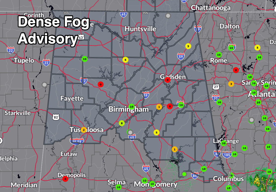
DENSE FOG ADVISORIES IN EFFECT
Dense fog has developed across much of northern and central Alabama tonight, prompting the National Weather Service to issue **Dense Fog Advisories** for a wide stretch of the state through 9 AM CDT Sunday. Visibility could drop to one-quarter mile or less at times across areas including Huntsville, Birmingham, Tuscaloosa, Gadsden, Auburn, and the I-20/59 and I-65 corridors. The fog may be especially dense in valleys and low-lying areas where winds are light and skies are clearing behind Saturday’s storms. Drivers should slow down, use low-beam headlights, and allow extra distance on the roads early Sunday morning until the fog begins to dissipate after sunrise.
CRISP AND CALM TODAY
Sunday begins with clearing skies and a noticeably cooler airmass in place behind yesterday’s front. Early morning lows dipped into the 40s and 50s across the state, and afternoon highs today will only climb into the upper 60s to lower 70s. A few clouds may drift through north Alabama this afternoon, but rain chances are nearly zero. Winds will be out of the northwest at 5–10 mph, adding a bit of crispness to the air. A few wraparound sprinkles can’t be totally ruled out across the Tennessee Valley, but most locations will stay dry.
CHILDREN’S OF ALABAMA INDY GRAND PRIX FORECAST – BARBER MOTORSPORTS PARK
Race day weather couldn’t be much better for fans headed to Barber Motorsports Park on Sunday. Gates open at 8:00 a.m. under mostly sunny skies and temperatures in the mid 50s. By the time the INDYCAR race goes green at 12:52 p.m., it will be sunny, breezy, and near 70 degrees. Northwest winds at 5–10 mph will keep conditions comfortable all afternoon with low humidity. It will feel more like March than May—pack a light jacket early and sunscreen for the midday sun. No rain is expected, and air quality will be excellent.
STALLIONS GAME DAY FORECAST – PROTECTIVE STADIUM, 3PM
The Birmingham Stallions will host the San Antonio Brahmas under sunny skies and ideal football weather. Kickoff temperatures will be around 70 degrees with a light northwest breeze. It will remain dry with falling humidity, and by the fourth quarter, readings will dip into the mid 60s. Fans can expect a crisp, comfortable spring afternoon with no need for ponchos or umbrellas—just sunglasses and team colors.
CLEAR AND COOL AGAIN TONIGHT
Temperatures will fall quickly after sunset tonight under a clear sky and dry air mass. Expect overnight lows in the mid to upper 40s across much of north and central Alabama, with isolated pockets dropping into the low 40s in sheltered valleys. Winds will be light and variable, and fog potential looks limited due to low humidity.
ONE YEAR AGO TODAY
On May 4, 2024, an upper-level low spinning over central Alabama kept showers and storms scattered across the region, especially over the northeast quadrant of the state. While some areas caught a break with sunshine, others dealt with stormy skies, occasional lightning, and brief downpours. Highs reached the 80s despite the clouds, and storms faded after sunset. It wasn’t a washout, but it was an unsettled spring day with plenty of action in the sky.
PLEASANT MONDAY, THEN UNSETTLED RETURNS
Monday will be another pleasant day with sunshine, highs in the low to mid 70s, and no rain in sight. However, a deep upper-level low near the southeastern U.S. will begin to retrograde westward and fling a series of disturbances our way starting Tuesday. Clouds increase Monday night, and by Tuesday night, scattered showers and storms begin to return to the forecast. This unsettled pattern will stick around for several days.
DAILY STORMS MIDWEEK
From Tuesday through Friday, we’re back in a more summer-like pattern of daily, mainly afternoon showers and thunderstorms. While no organized severe weather is expected, a few stronger storms are possible each day with heavy rain, gusty winds, and small hail. Highs will range from the mid 70s to low 80s through the period, with overnight lows mostly in the 50s and low 60s. The pattern is being driven by an upper-level trough over the eastern U.S., bringing moisture-rich air and daily instability to the region.
NEXT WEEKEND: DRIER, BUT STILL WATCHING
The forecast for next weekend looks a bit drier, but confidence is low. Depending on how long the trough lingers, we may still see isolated storms around Saturday. However, Sunday currently looks to trend drier with highs rebounding into the low to mid 80s.
VOODOO TERRITORY: BACK TO SUMMER?
Looking ahead to the week of May 12–18, medium-range guidance suggests the Southeast may begin transitioning back into a warmer and drier pattern. Temperatures could climb into the upper 80s again by mid-month, and ridging may reduce our rain chances. But it’s still early, and we’ll need to keep an eye on any lingering cutoff lows.
DANCIN’ WITH THE STATS
Tuscaloosa broke a daily rainfall record on Friday with 2.92 inches of rain, beating the previous record of 2.26 inches set in 1950. But the big numbers came out of College Station, Texas, where 4.32 inches fell—also a new daily record. Those are May totals with some March attitude.
SEVERE WEATHER OUTLOOK
According to the Storm Prediction Center, there is no organized severe weather threat for Alabama on Sunday. The greatest threat for strong to severe storms will remain well east of the state, across the Carolinas and portions of the Mid-Atlantic, where damaging winds and hail are possible. Alabama’s risk remains low thanks to cooler, more stable air in place.
TROPICAL OUTLOOK
Tropical activity is quiet in the Atlantic Basin. Hurricane season officially begins June 1, and no development is expected over the next seven days. We are now less than a month away from the official start, and Gulf waters are already warming quickly, so now is the time to begin thinking about your preparedness plan.
BEAUTIFUL BEACHES FORECAST
If you’re headed to the beautiful beaches of Alabama or northwest Florida today, it’s a breezy and pleasant day behind the front. Sunshine will return by afternoon, with highs in the upper 70s and north winds around 10 mph. The rip current risk remains moderate, and surf heights are around 2 feet. Water temperatures are in the upper 70s, perfect for a quick dip. Conditions will improve further Monday as winds relax and rip current risk drops to low.
WEATHERBRAINS PREVIEW
This week’s guest on WeatherBrains is Kati Wylie Ray, who will be discussing the devastating May 9, 1927 Poplar Bluff tornado. The show will stream live Monday night at 7 PM CDT on YouTube.com/WeatherBrains, and will be available afterward on all major podcast platforms. More information is available at WeatherBrains.com.
THIS DAY IN WEATHER HISTORY
In 2007, on this date, a massive supercell thunderstorm carved a path of destruction across western Kansas on May 4, 2007, spawning the first EF5 tornado ever rated under the new Enhanced Fujita Scale. The 1.7-mile-wide wedge tornado devastated the town of Greensburg, destroying 95 percent of the community and claiming eleven lives. Winds were estimated at 205 mph. Excellent warnings and early sirens saved countless lives that night, even as the storm carved out a historic place in tornado lore.
Category: Alabama's Weather, ALL POSTS, Severe Weather, Social Media
About the Author (Author Profile)
Bill Murray is the President of The Weather Factory. He is the site's official weather historian and a weekend forecaster. He also anchors the site's severe weather coverage. Bill Murray is the proud holder of National Weather Association Digital Seal #0001 @wxhistorianSubscribe
If you enjoyed this article, subscribe to receive more just like it.


