Severe Storms Continue With Hail, Wind, and Ongoing Warnings Across North Alabama
Severe thunderstorms continue to affect parts of north and west Alabama this evening. A warning remains in effect for northern Marshall and southwestern Jackson counties until 7:00 PM CDT, where a storm northwest of Guntersville is producing 60 mph wind gusts and quarter-size hail. Another warning remains in effect for northeastern Pickens County until 6:15 PM CDT, with a severe storm near Reform tracking east at 30 mph. Hazards with that storm include quarter-size hail and damaging wind gusts.
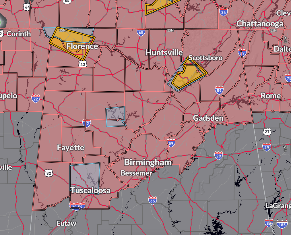
This is a new severe thunderstorm warning in effect until 7:00 PM CDT for central Lauderdale and central Colbert counties in northwestern Alabama. A severe storm located north of Cherokee is moving east at 25 mph and is capable of producing 60 mph wind gusts and quarter-size hail. The storm is expected to impact Florence, Muscle Shoals, Tuscumbia, and surrounding communities between 6:30 and 7:00 PM. Residents should move to an interior room and remain sheltered until the storm passes.
An earlier severe thunderstorm warning for north-central Walker and south-central Winston counties expired at 6:00 PM, but the storm that prompted it continues and has since been downgraded to a strong thunderstorm. It’s still producing nickel-size hail and gusty winds, and remains under a special weather statement through 6:30 PM.
A public report from Twin in Marion County confirmed hail up to 1 inch in diameter, associated with a second storm that passed through the area. The hail size matches radar estimates and was the largest confirmed so far today in Alabama.
Special weather statements remain in effect for parts of Winston, Walker, Madison, Jackson, and Marshall counties, where storms are still strong and capable of small hail, wind gusts up to 40 mph, and torrential rain. Frequent lightning is also occurring and may extend well ahead of the rain core.
Severe Thunderstorm Watch #239 remains in effect until 10:00 PM CDT and includes much of central and north Alabama—from Tuscaloosa and Birmingham to Huntsville and Florence. These storms are forming along a surface boundary under strong wind shear and 2500+ J/kg of instability, aided by a mid-level jet. Large hail and damaging winds remain the main threats. Storms are expected to weaken later this evening as daytime heating fades.
Category: Alabama's Weather, ALL POSTS, Severe Weather, Social Media
About the Author (Author Profile)
Bill Murray is the President of The Weather Factory. He is the site's official weather historian and a weekend forecaster. He also anchors the site's severe weather coverage. Bill Murray is the proud holder of National Weather Association Digital Seal #0001 @wxhistorianSubscribe
If you enjoyed this article, subscribe to receive more just like it.


