Midday Nowcast: Dry Today and Tomorrow; Some Scattered Strong Storms this Weekend
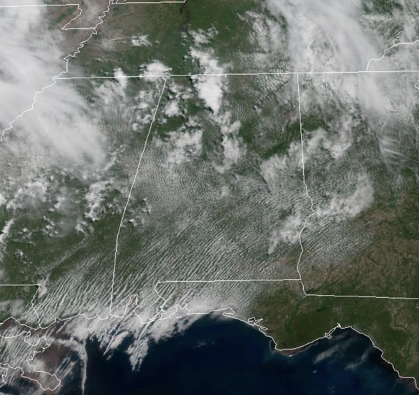
Today and tomorrow will be dry with a mix of sun and clouds both days. Afternoon highs will range from the upper 80s to lower 90s across all of Alabama. Tomorrow, severe weather is expected to the north of Alabama in the Mid-South and Ohio Valley ahead of a cold front. Some of the storms will drop into North Alabama very early Saturday morning as the cold front sinks south. These storms will be weakening as they move south, but will have the potential to produce gusty winds and hail.
BIRMINGHAM ALMANAC: For May 15th, the average high for Birmingham is 82° and the average low is 61°. The record high is 94° set in 1899, while the record low is 43° set in 1917. We average 0.16” of precipitation on this date and the record value is 3.00” set in 1983.
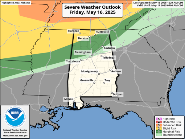
SOME STORMS THIS WEEKEND: The front slowly moves south into Alabama, and as daytime heating allows instability to increase, we are expecting additional showers and storms to develop by Saturday afternoon and evening. These will be scattered in nature, and rather random where they develop. Know it won’t rain everywhere, but where storms develop and move, they will pack a punch producing strong, gusty winds and some hail, along with heavy rainfall and frequent lightning. The Storm Prediction Center has issued a “marginal risk” (level 1 of 5) of severe storms Saturday for the northern two-thirds of the state. These will be predominantly driven by daytime heating, and should begin to weaken and dissipate after sunset.
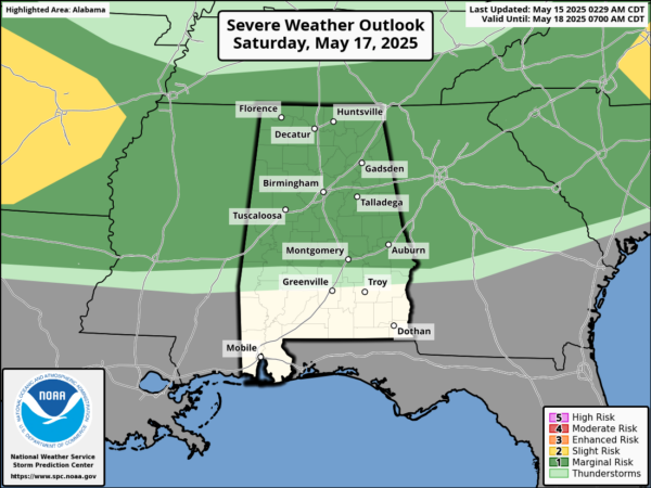
Sunday will be a near repeat of Saturday as the front will be stalled across northern portions of the state. Scattered, random thunderstorms will develop during the afternoon and evening hours. Again, these could produce gusty winds and small hail. Bottom line is that the weekend certainly won’t be a wash-out, but from time to time there will be some showers and thunderstorms.
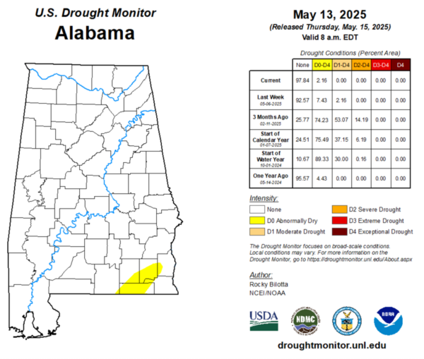
DROUGHT MONITOR: It’s Thursday meaning the latest drought monitor has been released. As expected, after all the recent rains, nearly all of Alabama is drought free this week. There is no Moderate Drought like last week, and only Abnormally Dry conditions for portions of Southeast Alabama, down in the Wiregrass region. Currently, 2.16% of the state is Abnormally Dry, with these conditions showing up in portions of Geneva, Covington, Dale, Coffee, Houston, Henry counties.
NEXT WEEK: Monday and Tuesday will be warm and muggy weather with highs in the 80s. Both days will generally be dry, but there will be some random, isolated afternoon and evening storms. By midweek, a widespread rain event is expected ahead of a strong cold front; a few strong storms will be possible as well. This front is forecast to push through the state, bringing a late season cool snap. Highs will fall into the 70s Thursday and Friday; lows will be mostly in the 50s and some spots in North Alabama dip into the 40s.
WORLD TEMPERATURE EXTREMES: Over the last 24 hours, the highest observation outside the U.S. was 116.2F at Bilma, Niger. The lowest observation was -101.0F at Vostok, Antarctica.
CONTIGUOUS TEMPERATURE EXTREMES: Over the last 24 hours, the highest observation was 112F at Rio Grande Village, TX. The lowest observation was 16F at Manila, UT.
Category: Alabama's Weather, ALL POSTS, Social Media
About the Author (Author Profile)
Macon, Georgia Television Chief Meteorologist, Birmingham native, and long time Contributor on AlabamaWX. Stormchaser. I did not choose Weather, it chose Me. College Football Fanatic. @Ryan_StinnetSubscribe
If you enjoyed this article, subscribe to receive more just like it.


