Severe Weather Watch Likely for Northern and Central Alabama – Issuance Expected Soon
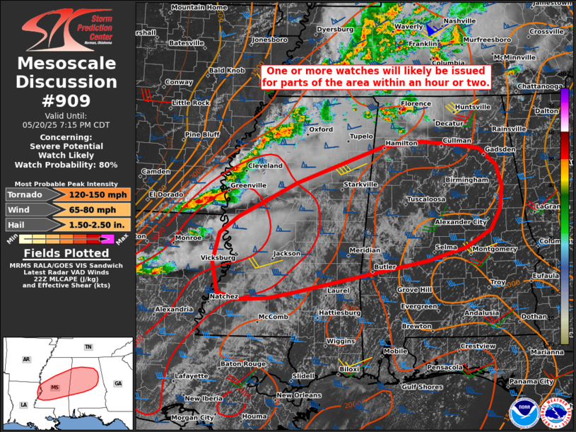
A severe weather watch is likely to be issued within the next hour or two for portions of northern and central Alabama as the risk for severe thunderstorms continues to increase.
Scattered strong to severe storms, including discrete supercells and organized clusters, are expected to move into Alabama from Mississippi ahead of a cold front. As these storms enter Alabama, they will encounter a highly supportive environment for severe weather, with strong instability and favorable wind shear in place.
This setup may support:
A few tornadoes
Damaging wind gusts
Large hail
Storms may eventually form into a broken line with embedded supercells as they spread eastward. Residents in the affected areas should closely monitor the weather and be ready to take action quickly if warnings are issued.
Category: Alabama's Weather, ALL POSTS, Severe Weather, Social Media
About the Author (Author Profile)
Scott Martin is an operational meteorologist, professional graphic artist, musician, husband, and father. Not only is Scott a member of the National Weather Association, but he is also the Central Alabama Chapter of the NWA president. Scott is also the co-founder of Racecast Weather, which provides forecasts for many racing series across the USA. He also supplies forecasts for the BassMaster Elite Series events including the BassMaster Classic.Subscribe
If you enjoyed this article, subscribe to receive more just like it.


