Threat of Tornadoes, Large Hail, and Damaging Winds for Northern Alabama
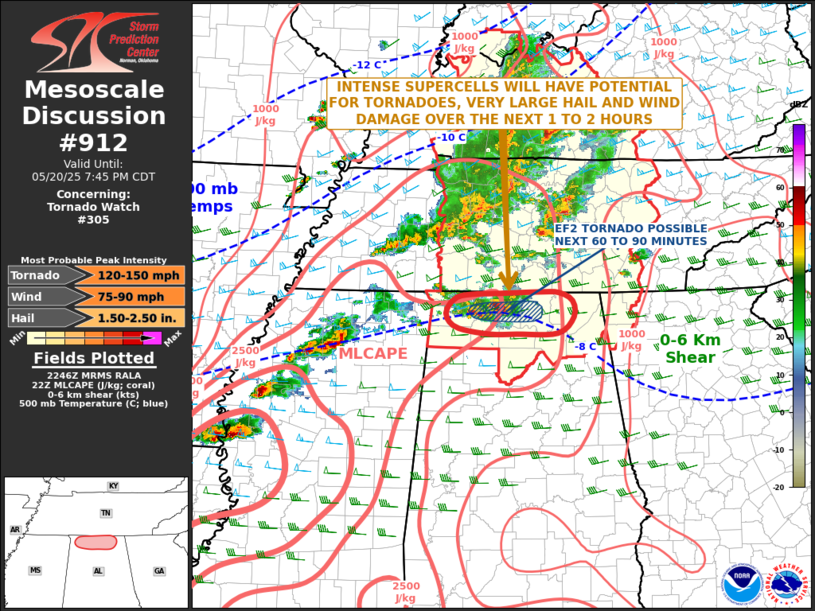
The National Weather Service Storm Prediction Center in Norman, OK, has issued this mesoscale discussion regarding Tornado Watch 305 in far northern Alabama, which remains in effect until 12:45 AM CDT. The threat for tornadoes, very large hail, and damaging winds will continue over the next couple of hours. Latest radar from Huntsville shows two intense supercells in the area near moderate instability, with MLCAPE around 2500 J/kg. Wind shear is strong with 0-6 km shear of 45 to 50 knots and 0-3 km storm-relative helicity near 200 m2/s2. These conditions favor intense supercell development. A tornado is possible, particularly as the two supercells interact, along with the potential for very large hail and wind damage.
Category: Alabama's Weather, ALL POSTS, Severe Weather, Social Media
About the Author (Author Profile)
Scott Martin is an operational meteorologist, professional graphic artist, musician, husband, and father. Not only is Scott a member of the National Weather Association, but he is also the Central Alabama Chapter of the NWA president. Scott is also the co-founder of Racecast Weather, which provides forecasts for many racing series across the USA. He also supplies forecasts for the BassMaster Elite Series events including the BassMaster Classic.Subscribe
If you enjoyed this article, subscribe to receive more just like it.


