Tornado Warning for Southwestern Madison, Southeastern Limestone, and Central Morgan Counties Until 7:30 PM CDT
The National Weather Service in Huntsville has issued a Tornado Warning for southwestern Madison County, southeastern Limestone County, and central Morgan County in north central Alabama. This warning is in effect until 7:30 PM CDT.
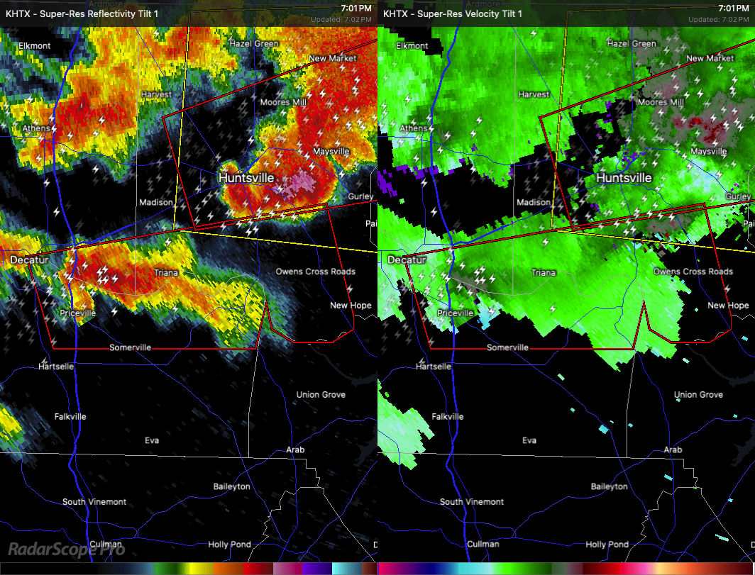
At 7:01 PM CDT, a severe thunderstorm capable of producing a tornado was located over Priceville, or 7 miles east of Decatur, moving east at 45 miles per hour. Radar has detected rotation within the storm, indicating the potential for a tornado along with quarter size hail.
Flying debris will be dangerous to anyone caught without shelter. Mobile homes could be damaged or destroyed. Damage to roofs, windows, and vehicles is expected, along with tree damage.
This dangerous storm will impact areas including Huntsville International Airport and Triana around 7:05 PM, Redstone Arsenal around 7:10 PM, Huntsville around 7:20 PM, and Owens Cross Roads around 7:25 PM. Other locations in the path include Laceys Spring, Valhermoso Springs, Farley, Mooresville, Hampton Cove, Whitesburg, and Somerville.
Take cover now. Move to a basement or an interior room on the lowest floor of a sturdy building and avoid windows. If you are outside, in a mobile home, or in a vehicle, move to the nearest substantial shelter and protect yourself from flying debris.
Category: Alabama's Weather, ALL POSTS, Severe Weather, Social Media
About the Author (Author Profile)
Scott Martin is an operational meteorologist, professional graphic artist, musician, husband, and father. Not only is Scott a member of the National Weather Association, but he is also the Central Alabama Chapter of the NWA president. Scott is also the co-founder of Racecast Weather, which provides forecasts for many racing series across the USA. He also supplies forecasts for the BassMaster Elite Series events including the BassMaster Classic.Subscribe
If you enjoyed this article, subscribe to receive more just like it.


