Day One Outlook Upgraded to Enhanced for Parts of Alabama
Here’s an update on the Alabama Weather Situation on this Sunday morning…
QUIET FOR NOW, BUT STORMS LIKELY LATER
As of midday, skies are partly to mostly cloudy across Alabama, with radar returns quiet for the time being. Temperatures at 11:00 AM range from the lower 70s in Haleyville and Gadsden to the mid 80s along the Gulf Coast and across parts of southeast Alabama. Huntsville reported 74 degrees with a muggy dewpoint of 67, while Tuscaloosa sat at 77 with scattered clouds. Montgomery had reached 82 with a mix of sun and clouds, and Mobile topped out at 85 degrees under mostly sunny skies. These conditions are typical of an unstable early summer setup across the Deep South, and the quiet won’t last long. A large thunderstorm complex is moving across the Mid-South and is expected to approach northwest Alabama later this afternoon and evening.
EVENING MCS ON THE WAY
The incoming thunderstorm complex—known as a mesoscale convective system, or MCS—is expected to intensify as it enters the Tennessee Valley between 4 and 8 PM. Some redevelopment ahead of the main system is also possible this afternoon, especially along and south of a weak boundary across central Alabama. The Storm Prediction Center continues to maintain a Slight Risk (level 2 of 5) for severe storms across much of the area today. The primary hazards remain damaging wind gusts up to 60 mph and quarter-size hail. Storms will be capable of producing intense lightning and torrential rainfall, and while widespread severe weather is not expected, some storms could become briefly intense through the evening hours.
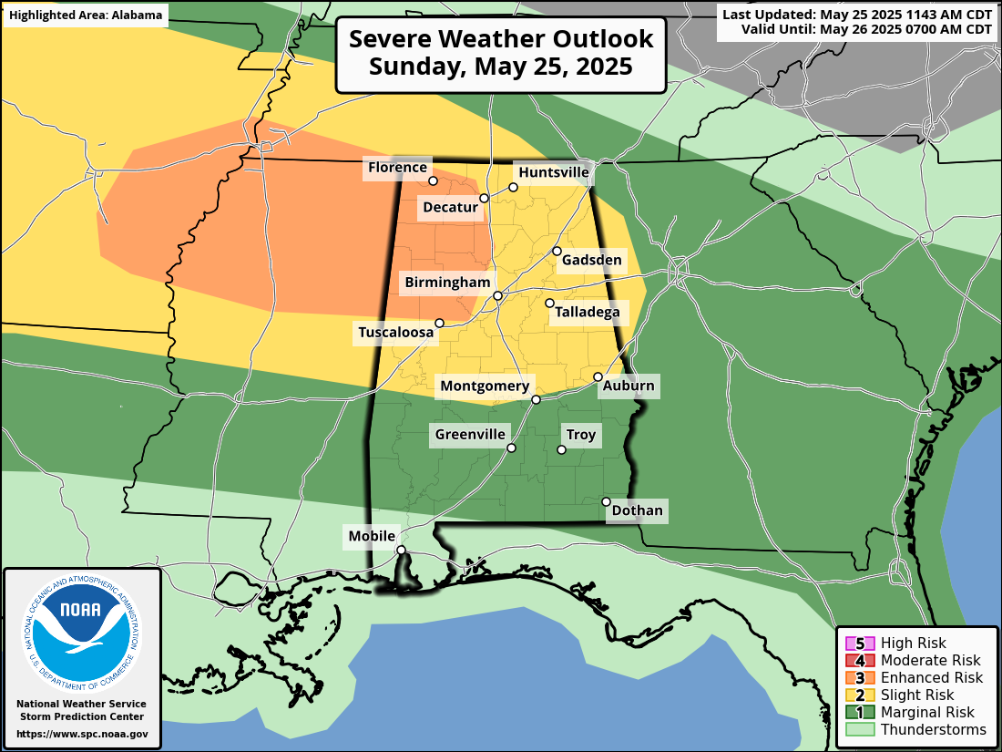
SPC UPGRADES PARTS OF ALABAMA TO ENHANCED RISK FOR TONIGHT
The Storm Prediction Center has upgraded parts of northwest and west-central Alabama to an Enhanced Risk (Level 3 of 5) for severe thunderstorms this afternoon and evening. This includes areas north and west of a line from Carrollton to Woodstock to Hanceville to Cullman to Athens and into the northwest corner of the state. Cities such as Tuscaloosa, Jasper, Cullman, Fayette, Hamilton, Decatur, and the Shoals are included. The primary threats are damaging wind gusts up to 60 mph and hail up to quarter size. Residents in these areas should remain weather aware through the day and have a reliable way to receive warnings.
MEMORIAL DAY STORM RISK
After a lull overnight, more storms are expected to fire again on Memorial Day. The setup remains favorable for daytime heating and afternoon destabilization, with another weak disturbance sliding across the region. The SPC has outlined another Marginal Risk (level 1 of 5) for Monday, covering most of central and north Alabama. Like today, damaging winds and hail will be the primary threats. Highs will range from the low 80s in the north to upper 80s in the south. Expect a mix of clouds and sun between showers, with most storm activity concentrated in the afternoon and early evening hours.
UNSETTLED THROUGH MIDWEEK
Tuesday brings yet another round of storms, and the SPC has already placed all of Central Alabama under a Marginal Risk once again. The overall pattern remains locked, with a stalled frontal boundary and a series of upper-level disturbances keeping the atmosphere primed for daily thunderstorm chances through midweek. While not every location will see storms each day, coverage will be widespread, and storms that develop could be strong to severe. Rainfall totals will begin to pile up across areas that see repeat activity, increasing the risk for localized flooding.
HINTS OF LATE WEEK IMPROVEMENT
The upper low responsible for this stagnant setup will begin to shift east by Friday. As it does, rain and storm coverage may begin to decrease slightly, but the chance for scattered storms will linger into next weekend. Temperatures will remain near seasonal norms, with highs in the low to mid 80s and muggy overnight lows in the 60s. We’ll continue to monitor trends for any sign of a sustained drying period, but for now, umbrellas and flexible outdoor plans are wise through at least Thursday.
Category: Alabama's Weather, ALL POSTS, Severe Weather, Social Media
About the Author (Author Profile)
Bill Murray is the President of The Weather Factory. He is the site's official weather historian and a weekend forecaster. He also anchors the site's severe weather coverage. Bill Murray is the proud holder of National Weather Association Digital Seal #0001 @wxhistorianSubscribe
If you enjoyed this article, subscribe to receive more just like it.


