Sunday Weather Briefing: Everything But the Kitchen Sink
June 1 marks the beginning of meteorological summer, the start of hurricane season, and this year, the arrival of a major solar storm. Sunday brings an interesting blend of celestial spectacle and earthly calm, with a severe geomagnetic storm watch in effect and a fresh surge of summer warmth spreading across the Southeast. In Alabama, we’ll enjoy a dry and quiet start to the week, with increasing heat and a gradually more unsettled pattern by week’s end. On the beaches, the weather is pristine, while space weather could steal the show.
QUIET START TO METEOROLOGICAL SUMMER
A deep upper trough over the eastern U.S. continues to exit stage right, leaving Alabama in the grip of dry, west-northwest flow today. Dewpoints are comfortable, skies will be mostly sunny, and high temperatures will run a few degrees below average, topping out in the lower 80s. Tonight, radiational cooling will take full effect under clear skies and light winds, dropping lows into the upper 50s to lower 60s. Canadian wildfire smoke aloft may keep skies a little hazy, especially in the Tennessee Valley.
SUNDAY STAYS BENIGN
Sunday will feature a reinforcing dose of early summer tranquility. A developing surface high over the Mississippi Valley will keep Alabama mainly dry, although a weak shortwave may generate a few isolated showers over the northern third of the state during the afternoon. Moisture return is modest at best, and most areas will stay rain-free. Expect highs to inch upward into the mid 80s in many locations, with increasing humidity by evening.
SMOKE TELLS OF A DISTANT TRAGEDY UNFOLDING
A veil of high-altitude smoke from ongoing Canadian wildfires continues to drift across parts of the central and eastern United States, including portions of the Deep South. While the smoke remains primarily aloft, it may lead to hazy skies and muted sunshine at times, especially across northern Alabama and the Tennessee Valley. Unlike in previous years, air quality impacts have been limited so far, but the upper-level flow could periodically push smoke into lower atmospheric layers depending on frontal passages and mixing. As long as the fires in Canada persist, occasional returns of this atmospheric haze are likely, offering a subtle but persistent reminder of distant blazes.
BUILDING HEAT THROUGH MIDWEEK
High pressure will strengthen across the Southeast early this week, bringing strong subsidence and sinking air that suppresses convection. Monday through Wednesday look dry and increasingly hot. Highs will climb from the upper 80s Monday to the low and mid 90s by Wednesday. Humidity will also tick upward, pushing heat index values toward the upper 90s. Overnight lows will trend warmer as well, ranging from the mid 60s to low 70s.
SEVERE WEATHER MONDAY AND TUESDAY
A broad upper trough stretching from the Rockies to the eastern U.S. will support a very active week of severe weather and heavy rainfall across large portions of the central and eastern states. On Monday, strong to severe storms are expected from the central and northern Plains into the Upper Midwest, with damaging winds, large hail, and isolated tornadoes possible. Through midweek, this threat shifts into the Mississippi Valley and Midwest, where multiple rounds of storms could lead to training cells and localized flash flooding. By Thursday and Friday, a stalling front across the Southern Plains and Lower Mississippi Valley will keep rain chances high, with 3 to 7 inches of rainfall possible in some areas, leading to an increasing risk of flooding, especially in already saturated regions. WPC and SPC outlooks highlight both excessive rainfall and severe thunderstorm risks through the week, with the potential for several organized MCSs and bowing segments.
LATE WEEK STORM CHANCES
By Thursday and Friday, the ridge begins to flatten as a trough slides into the northern Plains and Midwest. This will allow a front to edge southeastward and increase the risk of showers and storms across parts of the South, including Alabama. Coverage will remain scattered, but a few strong storms with gusty winds and brief downpours are possible. Highs will stay in the upper 80s to low 90s.
PEEK INTO VOODOO TERRITORY
Looking into week two, ensemble guidance suggests a return to a more active pattern for the Southeast. As ridging weakens and disturbances pass through a more zonal flow, daily storm chances may increase. Temperatures should hover near average, with highs in the mid to upper 80s and typical June humidity. This could also coincide with the start of the season’s first real tropical intrigue.
SEVERE WEATHER OUTLOOK
The Storm Prediction Center highlights central Oklahoma into north Texas for the greatest severe weather potential today. Large hail, damaging winds, and a few tornadoes are possible. For Alabama, no severe weather is expected today or Monday. However, a more significant severe weather setup is expected on Tuesday across parts of the Midwest and the southern Plains.
TROPICAL WEATHER OUTLOOK
Tropical storm formation is not expected through the next five days, with very strong wind shear dominating the Gulf, Caribbean, and much of the Atlantic. But attention may soon shift to the northwestern Caribbean by the end of next week, where model guidance hints at the potential for disturbed weather to organize. While any development remains uncertain and likely slow to occur, the region bears watching by next weekend.
FIRST DAY OF HURRICANE SEASON
Today marks the official beginning of the 2025 Atlantic hurricane season. NOAA is predicting an above-average season, with 13–19 named storms, 6–10 hurricanes, and 3–5 major hurricanes. Warmer-than-normal sea surface temperatures, a transition to ENSO-neutral, and an active West African monsoon all support increased tropical activity. The names for 2025 begin with Alberto and continue through William.
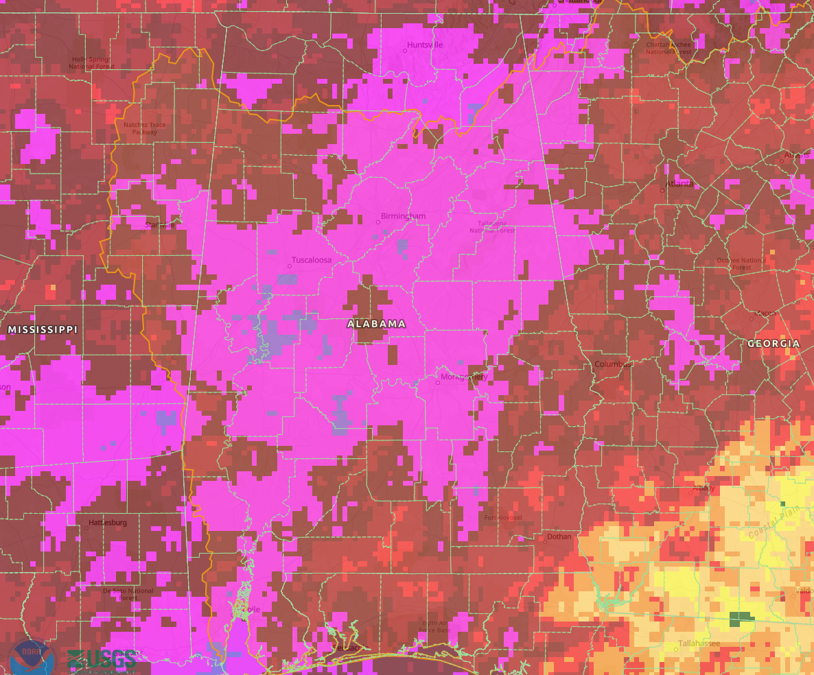
May observed rainfall totals over Alabama. Magenta if 10-15 inches. Purple is 15+ inches.
VERY WET MAY HEADLINES DANCIN’ WITH THE STATS
It was an amazingly wet May across Central Alabama, which is great news for summer drought and heat. Starting off with plenty of ground moisture as we head into summer is never a bad thing. Birmingham recorded its second wettest May ever with 11.29 inches at the Shuttlesworth International Airport. Tuscaloosa smashed its all time record May rainfall with 14.46 inches. The previous record was 11.13 inches in 1976.
SPACE WEATHER OUTLOOK
Heads up, stargazers: a powerful M8.2 solar flare erupted from sunspot 4100 on May 31, launching a fast-moving coronal mass ejection (CME) directly toward Earth. NASA and NOAA forecast the CME to arrive late June 1 or early June 2, potentially triggering a G4-class geomagnetic storm. Auroras may be visible as far south as the central U.S. This won’t rival May’s historic event, so probably nothing for us here in Alabama like may of 2024, but it could be among the most significant of Solar Cycle 25.
BEACH FORECAST
The beautiful beaches of Alabama and Northwest Florida will be picture-perfect this weekend. Mostly sunny skies, low rip current risk, and gentle surf around 1 foot will dominate through Monday. Highs will be in the mid 80s with lows in the low 70s. Water temperatures are solidly in the lower 80s. A modest uptick in rip current risk may arrive by midweek as winds turn onshore.
SAHARAN DUST STAYS SOUTH
A thick plume of Saharan dust, riding the trade winds from Africa, is blanketing parts of Florida this weekend, bringing hazy skies, brilliant sunsets, and reduced air quality—but Alabama will remain untouched. The Saharan Air Layer, which can suppress hurricane development and feed ocean life with nutrient-rich particles, will stay south of our state. FOr now, we will just deal with the Canadian wildfire smoke.
WEATHERBRAINS PREVIEW
This week on WeatherBrains, we welcome back Matt Lanza, a seasoned meteorologist recognized for his ability to clearly communicate weather impacts amid high-stakes scenarios. With a career spanning digital platforms and corporate forecasting, Matt’s level-headed analysis has been featured in outlets like The New York Times and BBC. We’ll also dive into his recent, thought-provoking article on the enigmatic Ryan Hall, Y’all—a piece that explores the intersection of new media, weather communication, and credibility in the digital age. We record Monday night in our normal time slot. Get it where you get your podcasts.
THIS DAY IN WEATHER HISTORY
On this date 1951…a series of severe thunderstorms swept across Alabama, bringing tragic consequences. In Morris, two individuals were killed by lightning while sitting beneath a tree. In Luverne, a man and his dog were fatally struck by lightning while working in a pasture. Another fatal lightning strike occurred in Brookwood, where a farmer was hit on his front porch. Tuscaloosa saw lightning damage at Van de Graff Airport, where a fire on a hangar roof and power loss forced commercial flights to divert. In Montgomery, strong winds injured a man who fell from a ladder, and downed trees blocked streets in the city.
Category: Alabama's Weather, ALL POSTS, Severe Weather, Social Media
About the Author (Author Profile)
Bill Murray is the President of The Weather Factory. He is the site's official weather historian and a weekend forecaster. He also anchors the site's severe weather coverage. Bill Murray is the proud holder of National Weather Association Digital Seal #0001 @wxhistorianSubscribe
If you enjoyed this article, subscribe to receive more just like it.


