Severe Weather Outlook For The Central Plains
The SPC released an outlook, the current Day One Severe Weather Outlook for this afternoon and tonight’s severe weather in the Central Plains states. They have a slight risk (level 2 of 5) from extreme southwestern Minnesota through southeastern South Dakota, across much of Nebraska, into parts of eastern Colorado, much of Kansas, western Oklahoma, and northwestern Texas.
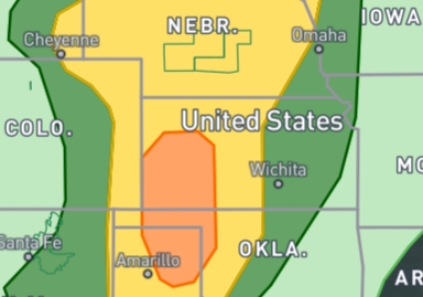
The forecasters at SPC have upgraded the area across southwestern Kansas and the Oklahoma and Texas Panhandles to an Enhanced Risk (level 3 of 5). The main risks and concerns are heavy rainfall, large hail, and severe damaging winds. The tornado risk is nonzero, but it is very low. The North Platte NWS in Nebraska explained in their forecast discussion that a tornado or two can’t be ruled out in that region for certain. They are noticing a higher helicity in the air, which is the spinning motion that, if caught by the updraft, could spin up a tornado.
The situation is due to a surface low-pressure system that is over southeastern Colorado that is passing northeast through the area, which will bring a cold front southeastward and set the stage for and creating some severe thunderstorms in the late afternoon and evening hours.
The dewpoints are in the mid-60s throughout the Texas and Oklahoma Panhandles, and this deeper moisture will spread northward throughout the afternoon into western Kansas, eastern Colorado, western Nebraska and into South Dakota. Which will limit the severity of the thunderstorms but will fuel these storms.
There is a strong level of instability levels will be strong, with CAPE values over 3,000 joules by mid-afternoon in the outlook area, which will favor thunderstorm updrafts. The bulk shear is not as impressive through the afternoon but will be increasing by late in the day and into the overnight as a low-level jet form across the region, but shear will not be as aggressive. There is a possibility for supercell development, which can enhance the which can be severe threat. However, there is no strong threat for tornado development; the 2% chance of tornado development is in Nebraska.
So, The North Platte NWS in Nebraska explained in their forecast discussion that a tornado or two can’t be ruled out in that region for certain. They are noticing a higher helicity in the air, which is the spinning motion that, if caught by the updraft, could spin up a tornado. The biggest concern, however, is the potential for damaging winds and a slightly lesser risk for large hail. There is also concern about heavy rainfall.
On the HRRR simulated radar, storms begin to develop around 3 pm, beginning in New Mexico, and Colorado and the Texas Panhandle. As they move into the southern plains, including southwestern Oklahoma and Kansas, they begin to grow and strengthen. These storms will weaken during the late-night hours. But storms with heavy rain will remain strong through the overnight over Nebraska, which flash flooding will be a concern. Flash flood watches are in effect.
Category: ALL POSTS, Headlines, Severe Weather, Social Media
About the Author (Author Profile)
Bill Murray is the President of The Weather Factory. He is the site's official weather historian and a weekend forecaster. He also anchors the site's severe weather coverage. Bill Murray is the proud holder of National Weather Association Digital Seal #0001 @wxhistorianSubscribe
If you enjoyed this article, subscribe to receive more just like it.


