Midday Nowcast: Warm, Hazy Day; Higher Rain Chances by the Weekend
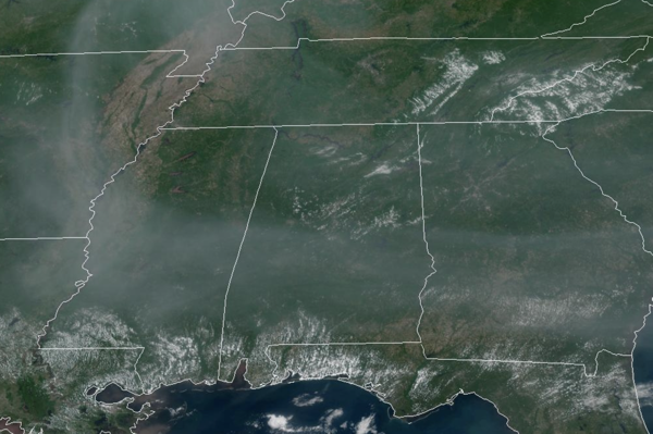
DRY START TO WEEK: Generally dry and very warm the next couple of days across Alabama with highs in the mid to upper 80s, and some low 90s each afternoon. The sky will feature a mix of sun and clouds, and the haze from the Canadian wildfires is still showing up on the satellite over Alabama and much of the Deep South. Moisture levels begin to increase on by Wednesday, and an isolated afternoon storm will be possible Wednesday and Thursday.
BIRMINGHAM ALMANAC: For June 2nd, the average high for Birmingham is 86° and the average low is 66°. The record high is 99° set in 2011, while the record low is 46° set in 1972. We average 0.16” of precipitation on this date and the record value is 1.53” set in 1970.
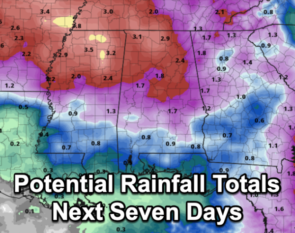
HIGHER RAIN CHANCES: By Friday, we bring in much better rain chances as scattered showers and thunderstorms will be more numerous on the radar during the afternoon and evening hours. Afternoon highs on Friday will be mostly in the upper 80s with a mix of sun and clouds when it is not raining.
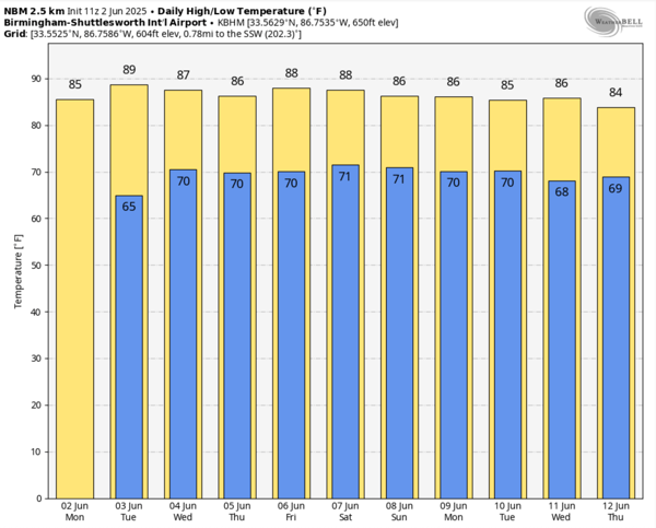
WET WEEKEND WEATHER: Sadly, the weekend is looking rather wet and unsettled as a surface front approaches from the north, but it stalls just to the north. The proximity of the front and high moisture levels means scattered to numerous showers and thunderstorms are in the forecast both Saturday and Sunday. Not a total wash-out, and the sun will peek out at times, but you will definitely want to keep the rain gear close. Highs over the weekend will be in the 80s. The unsettled pattern will continue into the first part of next week with highs holding in the mid to upper 80s.
IN THE TROPICS: For the North Atlantic, Caribbean Sea, and the Gulf of Mexico: Tropical cyclone formation is not expected during the next 7 days.
WORLD TEMPERATURE EXTREMES: Over the last 24 hours, the highest observation outside the U.S. was 117.3F at Bandar-E-Dayyer, Iran. The lowest observation was -99.6F at Vostok, Antarctica.
CONTIGUOUS TEMPERATURE EXTREMES: Over the last 24 hours, the highest observation was 112F at Stovepipe Wells, CA. The lowest observation was 25F at Sisters, OR.
Category: Alabama's Weather, ALL POSTS, Social Media
About the Author (Author Profile)
Macon, Georgia Television Chief Meteorologist, Birmingham native, and long time Contributor on AlabamaWX. Stormchaser. I did not choose Weather, it chose Me. College Football Fanatic. @Ryan_StinnetSubscribe
If you enjoyed this article, subscribe to receive more just like it.


