Sunday Weather Briefing: More Storms
NO VIDEO THIS MORNING WITH ONGOING SEVERE WEATHER
The active weather pattern continues across Alabama today and tomorrow, with multiple rounds of showers and storms expected. After a noisy night, a line of storms is shifting southward early this morning, with a brief lull expected by mid-morning. But another round of thunderstorms will redevelop by late morning or midday and persist into the evening hours. The unsettled pattern holds on through Monday, with more storms likely, especially by afternoon.
RECAP OF SATURDAY
Saturday brought widespread strong to severe storms across northern and central Alabama, with wind damage reports common across the state. Multiple rounds of storms impacted the region, including damaging gusts, downed trees, and over 130,000 power outages at one point.
ONGOING STORMS
Storms developed over Mississippi during the late evening and moved southeastward into Alabama along an avis of instability. Some of them showed signs of rotation in Mississippi, and at least one funnel cloud was reported, but no significant tornado reports were reecived. The storms moved into West Alabama after midnight, and a few storms have been severe with damaging winds being the main threat. Heavy rain is becoming a problem though, with the slow southward movement of the area of rain and storms. Flooding may result in some areas, especially those that have received heavy rainfall recently.
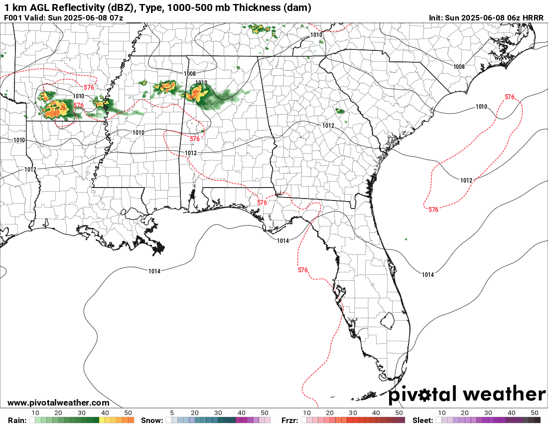
SEVERE WEATHER RISK TODAY
Storms will redevelop late this morning into the afternoon across much of the area. The Storm Prediction Center maintains a Level 2 (Slight) Risk across southeastern counties, including Auburn and Phenix City, and a Level 1 (Marginal) Risk for the rest of Central Alabama. Damaging wind gusts and isolated tornadoes remain possible. Large hail can’t be ruled out in stronger storms.
TONIGHT AND MONDAY
Showers and storms may persist past sunset tonight, with another surge of activity expected early Monday. A second round of strong to severe storms is likely again Monday afternoon and evening. The SPC has maintained a Level 2 (Slight) Risk for all of Central Alabama, with the threat of damaging winds, hail, and a few tornadoes continuing. It won’t rain the entire time, but stay weather-aware.
TUESDAY BRINGS A BREAK
A cold front should finally slide through the region late Monday night or early Tuesday, pushing moisture south and ushering in drier air. Tuesday and much of Wednesday will feature lower humidity, more sunshine, and quiet weather. Highs will be seasonable in the low to mid 80s.
UNSETTLED AGAIN LATER THIS WEEK
The quiet stretch won’t last long. Another system will approach by late Wednesday, bringing increasing chances for showers and thunderstorms Wednesday night through Friday. Instability will begin to rise again, and we may need to monitor for strong storms Friday into the weekend. Temperatures will climb into the upper 80s and low 90s by the end of the week.
A LOOK AHEAD TO NEXT WEEKEND
Saturday and Sunday both look warm and unsettled at this point, with the potential for scattered showers and thunderstorms each afternoon. No organized severe weather is expected just yet, but we’ll monitor trends in case stronger storms emerge with daytime heating.
SEVERE WEATHER OUTLOOK
Today’s enhanced risk for severe thunderstorms is centered on southern Oklahoma, northern Texas, and the Ark-La-Tex region. Storms there could produce hurricane-force wind gusts, very large hail, and a few tornadoes.
TROPICAL WEATHER OUTLOOK
Tropical cyclone development is not expected over the next five days, but longer-range models continue to signal trouble brewing in the western Caribbean or southern Gulf by the middle of next week. Increasing model consensus on a moist, unstable environment and the potential for a surface low to form beneath an upper trough keeps this region on the watch list. While nothing appears imminent, we will be keeping an eye on things. The GFS is now content that a huge upper ridge will protect the northern Gulf coast and steer any tropical mischief towards Mexico or extreme South Texas.
BEACH FORECAST
The beautiful beaches of Alabama and Northwest Florida will offer a summer classic this weekend—sunshine, heat, and rising surf. But beachgoers should be mindful of a moderate to high rip current risk across all beaches from Dauphin Island to Destin. Water temperatures are solidly in the lower 80s, with surf running 2 to 3 feet and southwesterly winds picking up to 10–15 mph. Scattered thunderstorms may develop each afternoon, but the mornings look sunny and inviting. Be sure to heed all beach flag warnings and stay hydrated.
WEATHERBRAINS PREVIEW
This week on WeatherBrains, we’re joined by two guests: Max Velocity, the popular YouTube storm chaser and communicator known for his high-energy weather explainers, and Kevin Laws from the National Weather Service, offering expert insight into forecasting challenges and storm communication. We’ll explore the evolving role of digital influencers in weather media and discuss how platforms like YouTube are shaping the future of public awareness. Catch the show live Monday night at 7 PM CDT on YouTube.com/WeatherBrains or download it anytime from WeatherBrains.com or your favorite podcast platform.
THIS DAY IN WEATHER HISTORY
A catastrophic F5 tornado struck the north side of Flint, MI, producing the deadliest tornado in the state’s history. The funnel, up to half a mile wide, carved a path of devastation along Coldwater Road, where over 200 homes were destroyed. Entire families were killed as the twister swept through residential neighborhoods without mercy. In total, 116 people died and 844 were injured. This tornado occurred during the deadly year of 1953 and was part of a broader, violent weather system that would go on to produce the infamous Worcester, MA tornado the following day. The Flint disaster remains the last single tornado to kill more than 100 people in the United States until the Joplin, MO EF5 in 2011. A tornado forecast had been issued for Michigan and Ohio by the fledgling Severe Weather Unit, a predecessor to the SELS, NSSFC, and today’s Storm Prediction Center.
Category: Alabama's Weather, ALL POSTS, Severe Weather, Social Media
About the Author (Author Profile)
Bill Murray is the President of The Weather Factory. He is the site's official weather historian and a weekend forecaster. He also anchors the site's severe weather coverage. Bill Murray is the proud holder of National Weather Association Digital Seal #0001 @wxhistorianSubscribe
If you enjoyed this article, subscribe to receive more just like it.


