Saturday Weather Briefing: Warm and Humid
NO VIDEO TODAY BECAUSE OF OTHER DUTIES
The calendar keeps inching closer to summer’s peak, and the days are about as long as they get. With the solstice coming next Friday evening at 9:41 p.m. CDT, we’re settling into a pattern typical for mid-June in Alabama: warm, humid air with daily rounds of showers and thunderstorms. Saturday will fit the script perfectly, with another dose of instability, high moisture, and scattered storms — none expected to be severe, but some with a punch. After a week that featured multiple rounds of organized storms and local flooding, the weekend offers more of the hit-or-miss variety. We’ll also start to see temperatures climbing a little higher heading into next week, flirting with early heat advisory territory by midweek.
STORMS LINGERING INTO THE WEEKEND
An upper trough over the Mississippi Valley will gradually shift east Saturday, maintaining enough lift aloft to interact with our moisture-rich airmass and spark scattered convection. Showers and thunderstorms will develop mainly during the afternoon hours, with coverage peaking mid to late afternoon. Rain chances are highest across the central and southern parts of the state, where deeper moisture and daytime heating will overlap. Though there’s ample instability, upper-level winds remain weak, so storms will remain pulse-type in nature. The main threats will be locally heavy rain, gusty winds, and frequent lightning — especially with slower-moving storms.
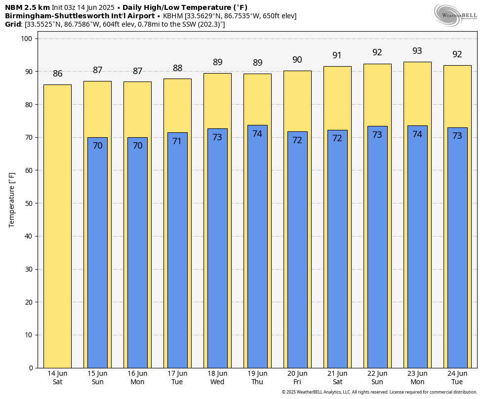
SATURDAY’S FORECAST
Saturday will be warm and very humid. Morning lows will be in the low 70s across most of Central and South Alabama. Highs will top out in the mid to upper 80s, tempered by cloud cover and scattered showers. Expect pockets of sunshine between rounds of rain. The best storm chances will occur between 1 and 7 PM. Saturday night will be mostly quiet with lows back in the lower 70s, although some showers may linger into the evening hours before gradually dissipating overnight.
A HUMID WEEK AHEAD WITH DAILY STORMS
Sunday through Wednesday will bring continued chances for afternoon and evening storms. Rain coverage looks highest Sunday and Monday, then slightly reduced by midweek. High temperatures will climb gradually each day, reaching the upper 80s and eventually brushing 90 degrees for many by Wednesday. Heat index values will rise as well, approaching the upper 90s to near 100 by midweek in spots. While this isn’t extreme by Alabama standards, it will be enough to warrant caution for outdoor plans, especially for vulnerable groups. Overnight lows will stay muggy, in the low to mid 70s.
LOOKING AHEAD TO THE SUMMER SOLSTICE
The summer solstice arrives at 9:41 PM CDT next Friday, June 20, marking the official start of astronomical summer — even though it’s already felt that way for a while. Friday and next weekend look seasonably hot and unsettled, with highs near 90 and daily scattered thunderstorms remaining in the forecast. By this point, upper-level ridging will begin to reassert itself across the southern U.S., but weak impulses and high moisture levels may keep daily storm chances going into next weekend.
A GLANCE INTO VOODOO TERRITORY
The week two period (June 22–28) leans toward a more classic southern U.S. summer setup: ridge-driven heat, with localized afternoon convection. There’s some ensemble agreement on expanding upper-level high pressure over the Southern Plains, potentially building into the Lower Mississippi Valley. If this verifies, Alabama could experience a period of hotter, drier days — but for now, rain chances remain in the forecast just about every day.
SEVERE WEATHER OUTLOOK
A slight risk (Level 2 of 5) of severe thunderstorms is in place for Saturday across parts of central Montana and the central High Plains, where scattered supercells and clusters may produce large hail and damaging winds, while additional isolated strong to severe storms are possible farther south into the central and southern Plains and as far east as the Southeast and Mid-Atlantic, though those threats remain more conditional.
DANCIN’ WITH THE STATS
??National High/Low temps for Friday: 111 at Death Valley, CA, Stovepipe Wells, CA; 30 at 13 miles northeast of Isabella, MN, Mount Washington, NH.
TROPICAL UPDATE
Tropical development remains unlikely in the near term, but forecasters are monitoring a tropical wave currently over the southwestern Caribbean that could reach the Bay of Campeche by mid to late next week. While strong wind shear and dry air are currently suppressing development, some model guidance—including the GFS and European ensembles—suggests a low-end chance (around 20–40%) of a system organizing in the Bay of Campeche or southwestern Gulf, possibly bringing heavy rain to eastern Mexico and potentially far South Texas. Confidence remains low, but this area bears watching through late next week.
BEACH FORECAST: CLASSIC JUNE WEATHER WITH A MODERATE RIP CURRENT RISK
Expect warm and humid beach conditions this weekend along the beautiful beaches of Alabama and Northwest Florida. Afternoon highs will be in the upper 80s, with water temperatures in the lower 80s. Scattered showers and thunderstorms are likely each afternoon, so plan indoor options during the 1–6 PM window. The rip current risk will be moderate both Saturday and Sunday, and surf heights will generally be 1 to 2 feet. UV indices will be very high, so don’t skimp on the sunscreen. Winds will be out of the south at 5–10 mph each day.
COMING UP ON WEATHERBRAINS
On the next episode of WeatherBrains — streaming live Monday evening at 7 PM CDT on YouTube.com/WeatherBrains — we’ll focus on the National Weather Association Annual Meeting, which takes place this fall in Huntsville. Join us as we chat about the organization’s mission, membership, and the role of local weather communities. As always, you can stream past episodes and subscribe to the podcast on all major platforms or visit WeatherBrains.com.
THIS DAY IN WEATHER HISTORY:
On this date in 2023, a brief EF0 tornado touched down around 11:21 PM near the intersection of County Roads 64 and 66 about two miles west of Loxley in Baldwin County, Alabama. The tornado’s southeastward path lasted just under a third of a mile and reached a width of 75 yards. It uprooted two large hardwood trees and produced minor, spotty damage. Fortunately, no injuries or fatalities occurred.
Category: Alabama's Weather, ALL POSTS, Severe Weather, Social Media
About the Author (Author Profile)
Bill Murray is the President of The Weather Factory. He is the site's official weather historian and a weekend forecaster. He also anchors the site's severe weather coverage. Bill Murray is the proud holder of National Weather Association Digital Seal #0001 @wxhistorianSubscribe
If you enjoyed this article, subscribe to receive more just like it.


