A Saturday Morning Alabama Weather Update: Storms Fire Early
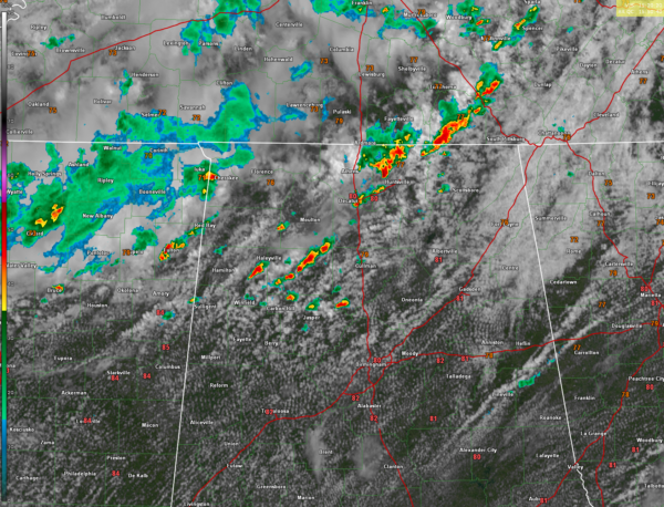
Scattered thunderstorms are erupting early this morning across North and Central Alabama, triggered by lingering outflow boundaries and aided by strong low-level lapse rates and deep moisture. Early activity developed across Madison, Limestone, Franklin, Lawrence, and Morgan counties, and is expanding south into Marion, Winston, Walker, and Cullman counties. With no cap and increasing instability, these storms are maturing quickly, capable of producing torrential rain, gusty winds, and frequent lightning. Thankfully, with deep-layer shear remaining weak, the storms are unlikely to sustain long-lasting severe behavior.
CURRENT CONDITIONS IN THE 10 O’CLOCK HOUR
Regional weather observations show temperatures already climbing into the low to mid 80s across much of Central and South Alabama, with dewpoints well into the 70s—a sign of a very moist atmosphere. Birmingham reported 80°F under partly sunny skies, Montgomery was at 83°F, and Huntsville reported 80°F despite morning storms. Radar confirms active showers and storms across northern and central parts of the state. Winds are generally out of the southwest around 5–10 mph. Skies range from partly to mostly cloudy across the region, with additional destabilization expected through midday.
MORE STORMS TO COME THIS AFTERNOON
The overall setup favors another round of widespread afternoon and evening showers and thunderstorms, much like Friday. Coverage will be high—greater than 70% in most areas—with storm development peaking during the afternoon and tapering off after sunset. These storms will be driven by daytime heating, boundaries from earlier storms, and subtle upper-level energy passing through. While organized severe weather is not anticipated, a few storms could still produce isolated strong wind gusts and brief localized flooding, especially where cells train or form repeatedly in the same area.
SUMMER PATTERN CONTINUES
Temperatures today will top out near 88–91 degrees in many locations before storms bring cooling rain and gusty outflows. This wet and stormy pattern will persist into Sunday, keeping humidity levels high and heat index values uncomfortable between storms. The summer solstice is now less than a week away, arriving Friday evening at 3:51 PM CDT, and Central Alabama is already well into a classic summertime regime of hot, humid days with afternoon and evening thunderstorms.
Category: Alabama's Weather, ALL POSTS, Severe Weather, Social Media


