Afternoon Update on the Alabama Weather Situation at 5 p.m.
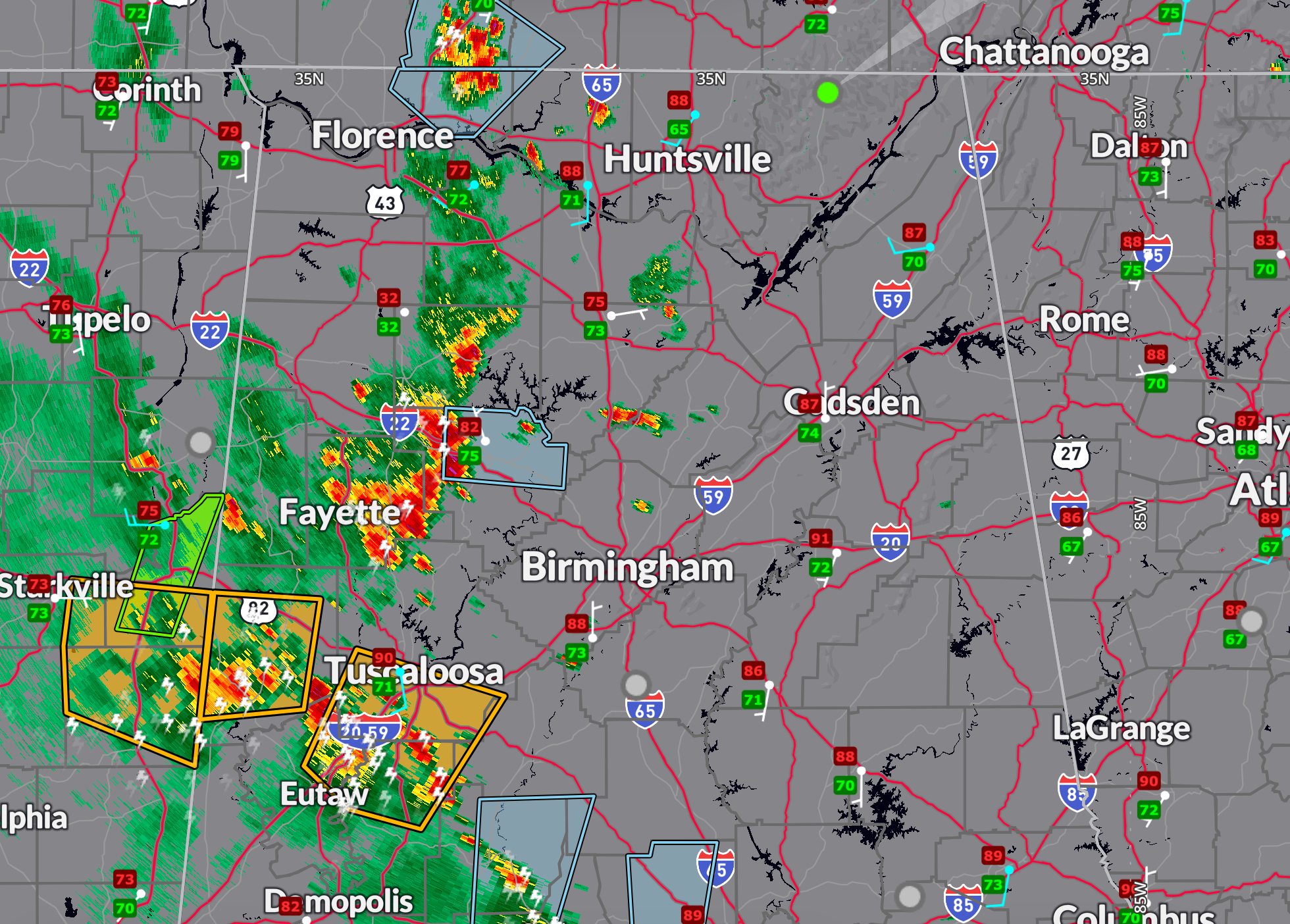
Strong to severe storms continue across West Central Alabama this afternoon.
Severe thunderstorm warnings are in effect for parts of Pickens, Tuscaloosa, Greene, Hale, and Bibb counties, including the City of Tuscaloosa as well aas Reform, Aliceville, and Moundville.
The thunderstorms are being fueled by rich Gulf moisture and surface temperatures climbing into the upper 80s and low 90s. They are forming in a moderately unstable environment with CAPE values between 2500–3000 J/kg, and will continue through the peak heating hours. While most storms will be sub-severe, a few could produce gusty winds and frequent cloud-to-ground lightning. The SPC has introduced a Marginal Risk (level 1 of 5) for strong storms across Northwest and West Central Alabama, where conditions are most favorable for isolated damaging wind gusts.
Ongoing storms in central Mississippi may evolve into a broader cluster or complex that moves northeastward toward the state later this afternoon and evening. However, latest high-resolution guidance (HRRR) shows these storms weakening as they approach Alabama, particularly after sunset. As a result, the best chance of more widespread thunderstorm activity will remain west of I-65, with coverage decreasing after dark. Still, scattered activity may persist into the early nighttime hours, especially in areas that remain unstable.
Tuesday brings an even higher chance of thunderstorms as a weak upper-level trough drops southeastward along the Mississippi River and moves toward Alabama by late afternoon. This added synoptic lift will coincide with peak heating, leading to a better organized round of scattered to numerous thunderstorms. Once again, damaging winds and intense lightning will be the primary threats. Temperatures will stay consistent, with highs near 90 and muggy overnight lows in the low 70s.
Category: Alabama's Weather, ALL POSTS, Social Media, Spacey Stuff
About the Author (Author Profile)
Bill Murray is the President of The Weather Factory. He is the site's official weather historian and a weekend forecaster. He also anchors the site's severe weather coverage. Bill Murray is the proud holder of National Weather Association Digital Seal #0001 @wxhistorianSubscribe
If you enjoyed this article, subscribe to receive more just like it.


