Wednesday Weather Briefing Video: Storms Today, Sizzle by the Weekend
I’m filling in for James Spann who is enjoying a much-deserved vacation. Tuesday brought another round of numerous showers and thunderstorms across Alabama, especially during the afternoon and evening hours. Some storms produced gusty winds up to 35 mph, frequent lightning, and locally heavy rainfall that led to isolated flooding. A few of them became severe, with damaging winds. Temperatures reached the mid to upper 80s prior to storm development.
SYNOPTIC OVERVIEW
An upper trough continues to advance toward the Great Lakes while a surface low moves through the Ohio Valley. Southwesterly flow aloft continues to pump deep Gulf moisture into Alabama. Though a weakening cold front remains well northwest of the area, the very moist air mass with precipitable water values exceeding 2 inches will support additional rounds of scattered convection across our state, especially during peak heating this afternoon.
TODAY’S WEATHER
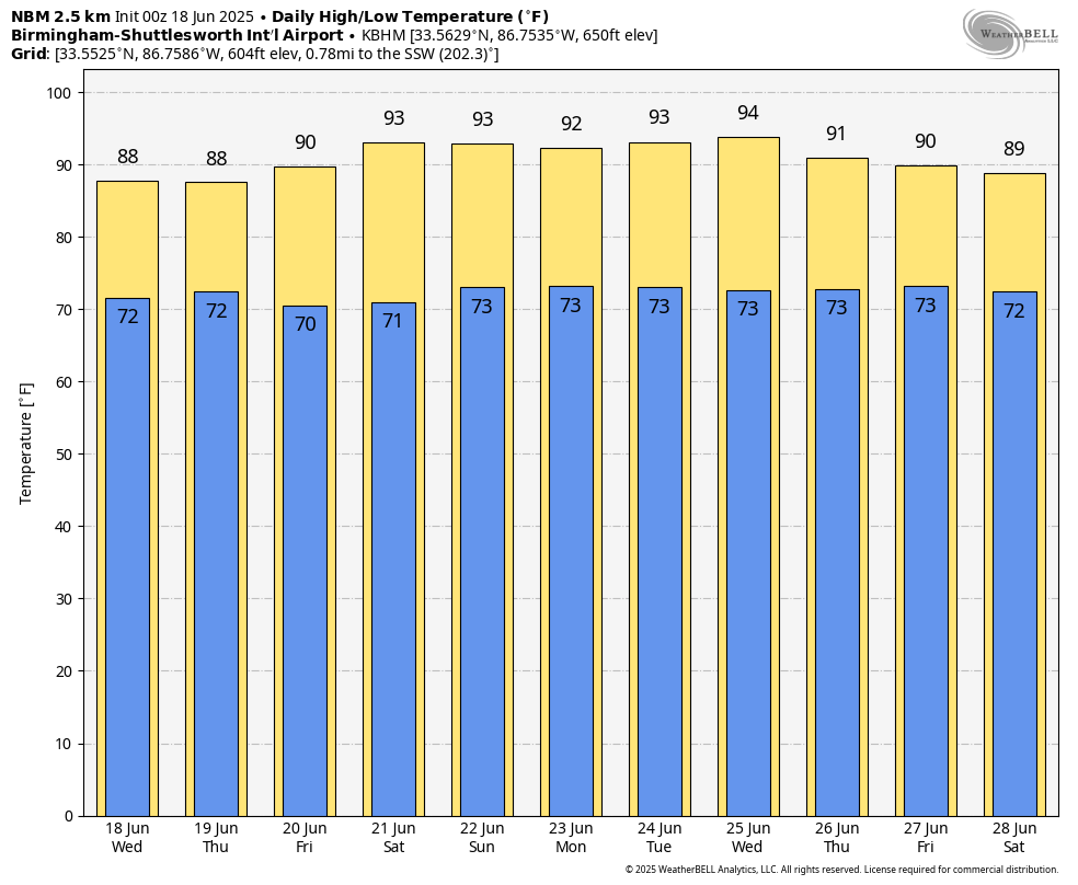
Scattered to numerous showers and thunderstorms will develop again today across North and Central Alabama, mainly from late morning through early evening. Some stronger storms could produce gusty winds, frequent lightning, and very heavy rainfall. The Storm Prediction Center has outlined the extreme northwest corner of Alabama in a marginal risk (level 1 of 5) for severe weather this afternoon and evening, with isolated damaging wind gusts the primary concern. Highs today will top out in the mid to upper 80s.
TONIGHT’S WEATHER
Showers and storms will gradually diminish after sunset as daytime heating is lost. Low clouds and patchy fog may form overnight in areas that received heavy rainfall earlier in the day. Overnight lows will settle into the lower 70s.
WEDNESDAY OUTLOOK
Another round of scattered showers and thunderstorms is expected Wednesday afternoon and evening. Coverage may be a bit higher than today as a weak mid-level disturbance moves across the region. Greatest coverage may focus across northern and northeastern Alabama where instability will be slightly higher. A few stronger storms could again produce gusty winds and heavy downpours. High temperatures will remain in the mid to upper 80s.
THURSDAY AND FRIDAY
Thursday brings an uptick in rain chances as a more organized midwest trough approaches. The Storm Prediction Center has placed parts of northeast and east-central Alabama in a marginal risk for severe storms Thursday afternoon and evening, with damaging winds the main hazard. On Friday, we begin transitioning into a hotter, somewhat drier pattern. Only isolated afternoon thunderstorms are expected, with highs returning to the upper 80s to near 90.
WEEKEND AND EARLY NEXT WEEK
A strengthening upper ridge will build over the Southeast this weekend and into early next week, leading to hot and mainly dry conditions. Highs each day will reach the lower to mid 90s, with only isolated afternoon thunderstorms possible. Heat index values may approach or exceed 100 degrees by Sunday and Monday.
NATIONAL SEVERE WEATHER OUTLOOK
A significant severe weather threat exists today well north of Alabama. An enhanced risk extends from southern Lower Michigan southwest into Indiana, Illinois, southern Missouri, and western Kentucky. This area will face a risk for widespread damaging winds, large hail, and a few tornadoes as a strong mid-level trough moves across the Midwest. Isolated severe storms are also possible across parts of the southern Plains and Mid-Atlantic region.
BEACH FORECAST
A moderate rip current risk continues today and Wednesday along Alabama and Florida Panhandle beaches, with surf heights around 2 feet. Water temperatures are in the mid 80s. Scattered thunderstorms will be possible each afternoon into the weekend. The UV index remains very high to extreme.
WEATHERBRAINS
This week’s episode was recorded early Thursday night due to James’ vacation. We talked with Jeff Givens, the Durango Weather Guy, a popular amateur meteorologist in Colorado.
ON THIS DATE IN 1815: The Battle of Waterloo was impacted heavily by weather. On June 16, Napoleon struck the Prussians at Ligny in Belgium. The French won the battle but suffered large casualties. Thunderstorms and heavy rain kept French troops from using their muskets effectively. On the 17th, Napoleon turned his attention to Wellington’s Anglo-Dutch forces. A thunderstorm began as the battle began, with heavy rain continuing through the afternoon. Mud slowed the French advance. By the 18th, clearing skies gave way to Prussian counterattacks that sealed Napoleon’s defeat.
Category: Alabama's Weather, ALL POSTS, Severe Weather, Social Media
About the Author (Author Profile)
Bill Murray is the President of The Weather Factory. He is the site's official weather historian and a weekend forecaster. He also anchors the site's severe weather coverage. Bill Murray is the proud holder of National Weather Association Digital Seal #0001 @wxhistorianSubscribe
If you enjoyed this article, subscribe to receive more just like it.


