Sunday Weather Briefing Video: Laughing Our Way into Summer as Storms Stay Away for a Change
Summer officially arrived this week, and the weather pattern across Alabama reflects the clash of deep moisture, hot temperatures, and building heat domes typical of late June. We sit under the southern edge of a sprawling ridge that’s baking much of the central and eastern U.S., while nearby frontal boundaries stir up thunderstorms to our north. While Alabama avoids the most extreme heat and severe storms for now, the days ahead will feature increasing heat, isolated afternoon storms, and growing signs of an oppressive heat wave taking hold into the heart of next week.
THE BIG PICTURE ALOFT
A powerful upper ridge remains anchored across the Ohio Valley, Mid-Atlantic, and Southeast while a persistent western trough brings repeated shortwaves into the northern Plains and Midwest. This places Alabama beneath weak southwest flow aloft, drawing in ample Gulf moisture. Precipitable water values remain elevated, generally above 1.8 inches, and modest instability combines with daily heating to produce scattered showers and thunderstorms, though widespread organized severe weather is not anticipated locally.
SUNDAY WEATHER OUTLOOK
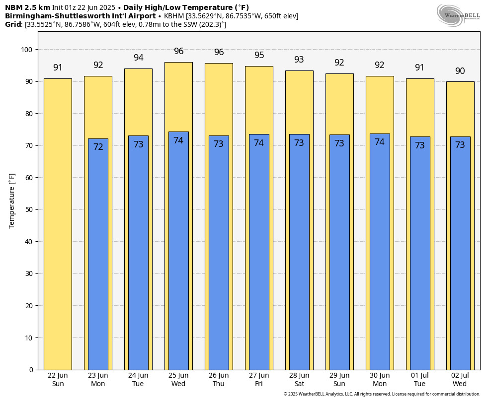
Today will be a typically hot, humid June day across North Alabama. Highs will climb into the lower 90s for many locations, with afternoon heat indices creeping toward 100 degrees. Isolated showers and thunderstorms are expected during peak heating hours, but coverage will be limited, with most storms confined to western Alabama, where slightly better boundary convergence exists. Storms that do form could produce locally heavy rainfall, frequent lightning, and gusty winds. The stronger upper-level subsidence on Sunday should limit widespread activity.
SPOTLIGHT ON THE COCA-COLA AMPHITHEATER OPENING
Tonight marks a milestone for Birmingham as the long-anticipated Coca-Cola Amphitheater opens its doors for the first time. Located at 2350 15th Avenue North, this state-of-the-art 9,300-seat venue will launch its inaugural season with comedian Matt Rife taking the stage this evening. While a few isolated thunderstorms may develop across the Birmingham area during the afternoon, storms should dissipate well before showtime at 7:30 PM, allowing for a pleasant summer evening under mostly clear skies. The Coca-Cola Amphitheater promises to become a centerpiece of downtown entertainment, drawing major acts from Rod Stewart to Phish in its first season. Dave Matthews comes calling Tuesday night!
MONDAY THROUGH MIDWEEK
The upper ridge strengthens and expands directly overhead by Monday and Tuesday, bringing hotter temperatures and suppressing much of the afternoon convection. Highs will reach the mid to upper 90s by midweek, with heat indices possibly exceeding 105 degrees in some locations by Wednesday. Patchy fog is possible each morning where overnight radiational cooling and previous rain allow moisture to pool near the surface. Rain chances remain low through Wednesday, limited mainly to isolated afternoon storms where boundaries interact with strong surface heating.
LATE WEEK AND NEXT WEEKEND
By Thursday and Friday, the ridge begins to flatten slightly as weak upper disturbances brush by to our north. This may allow for slightly better rain chances Thursday and Friday afternoons, but widespread organized storms are still unlikely. Highs will continue to reach the mid 90s with heat indices hovering between 100 and 105 degrees. As we move into next weekend, signs point to a “dirty ridge” pattern setting up, where afternoon and evening thunderstorms could become more frequent while daytime heat remains intense.
LOOKING INTO VOODOO TERRITORY
The week two outlook shows continued above normal temperatures dominating the Southeast, with persistent ridging keeping Alabama locked into a hot, humid pattern. Model ensembles suggest occasional upper disturbances may bring periodic rounds of afternoon thunderstorms, but no significant pattern change is apparent at this time. The oppressive heat gripping the central U.S. may shift eastward slightly by late week two, bringing Alabama closer to the core of the high heat dome.
SEVERE WEATHER OUTLOOK NATIONWIDE
The Storm Prediction Center highlights an active severe weather threat to our west on Sunday. A slight risk extends from the northern Plains into the Upper Mississippi Valley, including parts of eastern North Dakota, northern Minnesota, and surrounding regions. Strong instability coupled with a strengthening surface low will support the potential for very large hail, damaging winds over 75 mph, and isolated tornadoes in northern Minnesota where low-level shear will be most favorable. Additional severe storms are possible across parts of the Northeast where remnant MCS activity may redevelop into scattered strong storms during the afternoon. Farther south into the Central and Southern Plains, isolated severe storms may develop along the trailing frontal boundary with mainly wind and hail threats.
TROPICAL OUTLOOK
The National Hurricane Center continues to monitor the Atlantic Basin, but tropical cyclone formation is not expected during the next 7 days. The Atlantic remains quiet as we move deeper into the early portion of the hurricane season.
BEAUTIFUL BEACHES OF ALABAMA AND NORTHWEST FLORIDA
Beachgoers along the Alabama and Northwest Florida coasts can expect mostly sunny skies with only isolated afternoon showers and thunderstorms both Sunday and Monday. Surf heights will remain around 1 foot with water temperatures holding in the mid 80s. The rip current risk remains low across the entire coastline, offering generally safe swimming conditions. However, always remain aware of local flag warnings, as dangerous currents can still form near jetties and piers. UV indices will remain extreme, so sun protection remains essential for all beach visitors.
WEATHERBRAINS
On this week’s WeatherBrains episode, we’ll be spotlighting the National Weather Association with organization officials, board members, and volunteers Becca Mazur, Matt Beitscher, Kendra Kent, and Isaac Williams. The panel will discuss the NWA Broadcast Committee’s latest efforts to streamline the Digital Seal, update certification processes, and promote membership growth. WeatherBrains streams live Monday evening at 7 PM CDT on YouTube at youtube.com/weatherbrains, and the audio podcast is available at weatherbrains.com and all major podcast platforms.
DANCING WITH THE STATS
The central U.S. heat wave continues to shatter records: McCook, NE is forecast to hit 107 degrees today which would set a new daily record. Mitchell, SD is expected to reach 104, Minneapolis 97, St. Cloud 89, and even Marquette, MI may climb to 89 degrees. Dangerous heat indices continue to accompany these record highs.
WEATHER HISTORY
On this date in 1963: During the night of June 22 into the 23rd, very heavy rainfall led to localized flooding in Alabaster in Shelby County. A dam for a 14-acre lake broke, sending a wall of water into parts of the town. Approximately 32 homes, 20 farm buildings, and 12 businesses were damaged by high water. Flooding also impacted the Saginaw and Pelham communities. Roads and highways were closed for several hours.
Category: Alabama's Weather, ALL POSTS, Social Media
About the Author (Author Profile)
Bill Murray is the President of The Weather Factory. He is the site's official weather historian and a weekend forecaster. He also anchors the site's severe weather coverage. Bill Murray is the proud holder of National Weather Association Digital Seal #0001 @wxhistorianSubscribe
If you enjoyed this article, subscribe to receive more just like it.


