Scattered Storms Continue with a Brief Front and Some Heat Relief on the Way
FIREWORKS EXPECTED THIS WEEKEND & THE 4TH IS NOT EVEN HERE YET
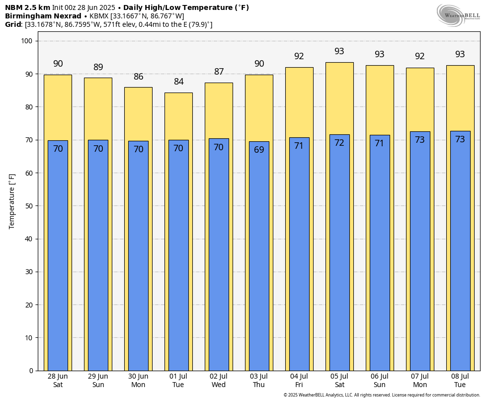
For today, a textbook summer setup continues with scattered afternoon and evening thunderstorms likely, especially where sunshine heats the ground and helps storms fire along boundaries. Weak winds aloft mean storms will barely move, so localized flash flooding will be something to watch for. While the risk for damaging winds is fairly low, a few storms may still produce gusts up to 40–50 mph. Heat index values could approach 100, but overall it’ll feel just like what we expect this time of year. Highs will be in the upper 80s to lower 90s.
There will be not much change from Saturday on Sunday… Expect another round of slow-moving storms developing during the hottest part of the day. Any storm could bring brief heavy rain and gusty winds, though widespread severe weather isn’t on the table. The overall environment becomes a little more moist and unstable, but that will actually reduce the risk for damaging downbursts. Still, flooding could remain an issue in spots that see repeated rounds of rain. Highs will be in the upper 80s to lower 90s.
A BRIEF COOL DOWN BEFORE HEAT CRANKS BACK UP FOR THE 4TH
On Monday, a cold front begins pushing into the Tennessee Valley from the north, increasing rain and thunderstorm chances during the day. Widespread severe weather isn’t likely, but with growing instability, a few strong storms are possible, especially in the afternoon and evening hours. The front may not bring a huge temperature drop, but it will shave a bit off the heat. Highs will range from the lower 80s in rain-cooled areas to the lower 90s farther south.
Tuesday shows the front sagging farther south, and many locations will stay under cloud cover or scattered showers for much of the day. Rain chances are highest early in the day, then become more hit-and-miss by the afternoon. Humidity levels begin to ease just a bit behind the front, and it’ll feel more tolerable compared to the weekend. Highs will be in the 80s across the board.
On Wednesday, the front stalls somewhere near or just south of I-20, with lingering moisture and weak disturbances riding overhead in a northwest flow. While it won’t be a washout, scattered showers and thunderstorms remain possible, especially during the afternoon and evening. Still, the air will feel a bit less muggy across northern sections, and some locations may stay dry altogether. Highs will range from the mid 80s in the north to the lower 90s in the south.
Unsettled weather continues on Thursday, as weak upper-level energy and a lingering boundary keep daily storm chances in the forecast. Expect scattered showers and thunderstorms again, mainly in the afternoon and early evening hours. No organized severe weather is expected, but locally heavy rain and gusty winds are possible with stronger storms. Highs will be in the upper 80s to lower 90s.
And on Independence Day, a more defined northwest flow pattern aloft sets up, and we’ll need to watch for any thunderstorm complexes that might develop upstream and drift into the area. These “MCS-type” systems can produce clusters of strong storms with wind and heavy rain, especially across northwest Alabama. Timing and track are uncertain for now, but this is something to monitor. Otherwise, expect another day with scattered storms, especially in the afternoon. Highs will range from the upper 80s to the mid 90s.
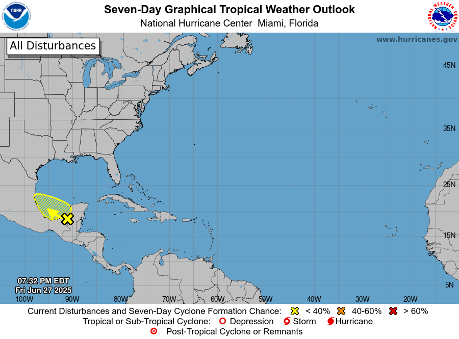
TROPICAL UPDATE
We are watching a broad area of low pressure centered over the southwestern Yucatán Peninsula. It’s producing disorganized showers and storms over land and nearby waters. This system is expected to move into the Bay of Campeche tonight, and while environmental conditions aren’t great, there is a brief window Saturday and Sunday for some tropical development if it stays over water. By Monday, it should move inland over eastern Mexico, cutting off any further chances for strengthening. Right now, the chance of development remains low — around 30 percent over the next two days and through the next week. Regardless of development, heavy rain is likely for parts of Belize, Guatemala, and southeastern Mexico.
Category: Alabama's Weather, ALL POSTS, Social Media, Tropical, Weather Xtreme Videos
About the Author (Author Profile)
Scott Martin is an operational meteorologist, professional graphic artist, musician, husband, and father. Not only is Scott a member of the National Weather Association, but he is also the Central Alabama Chapter of the NWA president. Scott is also the co-founder of Racecast Weather, which provides forecasts for many racing series across the USA. He also supplies forecasts for the BassMaster Elite Series events including the BassMaster Classic.Subscribe
If you enjoyed this article, subscribe to receive more just like it.


