Stormy Skies and Steamy Days, as Well as a Few Tropical Whispers
MUGGY MORNING, ACTIVE AFTERNOON ON TAP
Skies are partly to mostly sunny across Central and North Alabama this morning, with temperatures already climbing through the upper 70s and lower 80s in places like Birmingham (81°), Tuscaloosa (80°), and Huntsville (80°). A steamy air mass remains firmly in place, with dewpoints in the mid 70s and surface moisture pooling ahead of another active afternoon of thunderstorms. As of 9 AM, isolated showers were already trying to pop along remnant outflow boundaries. Expect thunderstorm initiation by late morning to midday—especially across North and Central Alabama—followed by southward propagation into the afternoon.
WIDESPREAD STORMS WITH LOCALLY HEAVY RAINFALL
The setup today features a subtle shortwave gliding around the edge of Gulf ridging, enhancing vertical motion across the region. PWATs are rising to over 2 inches, and that means plenty of moisture to work with. Expect numerous to widespread showers and storms through the day, particularly across the northern half of the state where activity may begin as early as 10–11 AM. While no severe weather is expected, gusty winds, frequent lightning, and torrential downpours are likely in stronger storms. Given the soggy soils from previous rain and slow storm motion, localized flash flooding could be an issue, especially in urban or low-lying areas.
UNSETTLED START TO THE WEEK
The wet pattern continues into Monday as a deepening trough approaches from the Midwest and a weak frontal boundary begins to sag into Alabama. Expect another day of high storm coverage, with scattered showers possible early and more widespread development by the afternoon. Saturated profiles will limit severe wind risk, but isolated microbursts, heavy rain, and dense lightning remain concerns. This frontal boundary will stall over or near the state through midweek, continuing our above-normal rain chances through at least Wednesday.
DAYS GET HOTTER LATER THIS WEEK
As the front weakens and retreats to the Gulf by Thursday, a shift toward drier air will allow temperatures to rise again. Highs in the mid 80s early in the week will climb back into the lower 90s by Friday and Saturday, with heat index values pushing the upper 90s in many areas. Rain chances will taper off during the second half of the week, although a few isolated afternoon storms can’t be ruled out. The weekend looks hot, humid, and mainly dry, though we’ll be watching the Gulf closely for potential tropical developments.
The latest two runs of the GFS model backed off on the idea of a significant tropical cyclone developing in the northern Gulf in the week ahead. Which we figured. But can’t let our guard down.
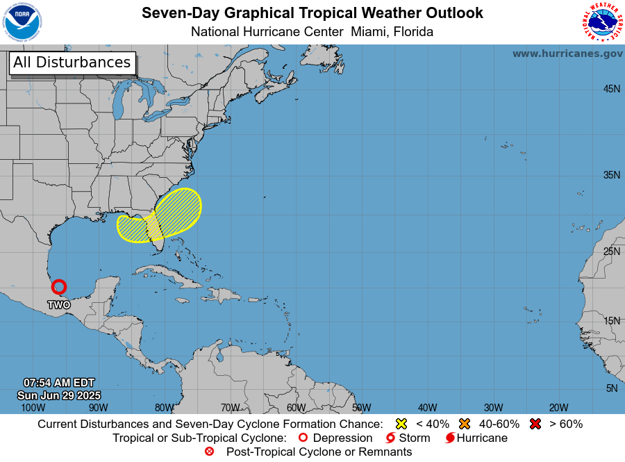
POSSIBLE GULF DEVELOPMENT LATER THIS WEEK
It’s that time of year, and right on cue, eyes are turning to the northern Gulf of Mexico where the National Hurricane Center has introduced a 20% chance of tropical development over the next seven days. The potential setup involves a lingering frontal boundary draped along or just offshore of the northern Gulf Coast later this week. With warm waters and deep moisture in place, conditions may gradually become marginally favorable for a weak area of low pressure to form, especially as we head into the weekend. While no organized system is expected in the short term, this is a pattern that bears watching, particularly for coastal Alabama, the Florida Panhandle, and surrounding areas. NWS Mobile noted this morning that nothing imminent is expected, but as always, we’ll be keeping a close eye as the atmosphere evolves.
NATIONAL WEATHER HEADLINES: SEVERE STORMS AND SOAKING RAINS ON TAP
A slow-moving frontal boundary draped from the Rockies to the Great Lakes and Appalachians will once again be the focus for widespread thunderstorm development today. The most intense storms are expected from eastern Nebraska through Iowa into Wisconsin, where the Storm Prediction Center has outlined a risk for damaging winds, large hail, and isolated tornadoes. These storms will track eastward into the Mississippi Valley on Monday, eventually reaching the Mid-Atlantic by midweek. Meanwhile, scattered strong thunderstorms are expected across the Tennessee Valley, Southeast, and southern Plains this afternoon, capable of gusty winds and torrential downpours. Locally heavy rainfall of 2–3 inches could lead to flash flooding from parts of Iowa into northern Missouri, with additional flooding concerns possible in the Carolinas and Mid-Atlantic due to slow-moving convection in a muggy air mass.
TROPICAL UPDATE: TROPICAL DEPRESSION TWO NEARS LANDFALL IN MEXICO
Tropical Depression Two is hugging the southern Gulf coast of Mexico this afternoon, and although the system remains disorganized on radar and satellite, the National Hurricane Center continues to project it may briefly strengthen into a tropical storm before landfall later today. Regardless of classification, the depression is already producing very heavy rainfall across eastern Mexico, particularly in the states of Veracruz, San Luis Potosí, and Tamaulipas, where flash flooding and mudslides are possible through Monday. The system poses no threat to the U.S. Gulf Coast, but it serves as a reminder that tropical development near land can escalate quickly—even in marginal conditions.
Category: Alabama's Weather, ALL POSTS, Tropical
About the Author (Author Profile)
Bill Murray is the President of The Weather Factory. He is the site's official weather historian and a weekend forecaster. He also anchors the site's severe weather coverage. Bill Murray is the proud holder of National Weather Association Digital Seal #0001 @wxhistorianSubscribe
If you enjoyed this article, subscribe to receive more just like it.


