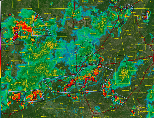
Radar Update at 3:45 and Barry Nearing Landfall in Eastern Mexico
Our thunderstorms have congealed into a loosely organized squall line this afternoon that extends from Calhoun County in eastern Alabama though Talladega and eastern Shelby into Bibb, Greene, and northern Sumter counties. There is noticeably little activity in Hale County interestingly enough.
Additional storms are ahead of the line over Chilton, Coosa, Clay, and Tallapoosa counties.
Other storms are entering Northwest Alabama from northeastern Mississippi, but so far they appear to be weakening a bit.
The line and antecedent storms are pushing southeast.
Significant weather advisories blanket the territory ahead of the line, meaning none of the storms are severe at this time. The threat is for heavy rain, dangerous lightning, and gusty winds. No reports of damage have been received. There has been some minor flooding with the saturated soils and runoff.
Winds have been gusting to about 30-40 mph in the stronger cells.
THE LATEST ON TROPICAL STORM BARRY
Tropical Storm Barry continues its northwestward approach toward the eastern coast of Mexico this afternoon, with maximum sustained winds holding at 45 mph. The center of Barry was located about 35 miles northeast of Tuxpan and is expected to make landfall this evening near Cabo Rojo, between Tuxpan and Tampico. While the system remains disorganized on satellite imagery—with most of the deep convection displaced southeast of the center—radar and earlier reconnaissance data support maintaining Barry as a 40-knot tropical storm.
As Barry tracks inland tonight, rapid weakening is forecast due to interaction with the mountainous terrain of east-central Mexico. The storm is expected to become a remnant low or dissipate completely by late Monday. The official forecast track has shifted slightly right of previous guidance but remains in line with the ECMWF model solution, showing a continued northwestward movement before Barry loses tropical characteristics.
The main threat from Barry remains the heavy rainfall expected across the Mexican states of Veracruz, San Luis Potosí, and Tamaulipas. Widespread totals of 3 to 6 inches, with isolated amounts up to 10 inches, are possible. Flash flooding and dangerous mudslides are a serious concern, especially in hilly or mountainous regions. Tropical storm conditions, especially strong gusts, are likely this evening along the coast before conditions begin to improve late tonight.
Category: Alabama's Weather, ALL POSTS, Severe Weather, Social Media, Tropical


