Afternoon Storms Through Wednesday; Drier Thursday/Friday
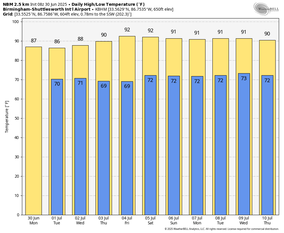
AM SUN/PM STORMS: Alabama’s weather won’t change through Wednesday. Partly to mostly sunny mornings, followed by scattered to numerous showers and thunderstorms during the afternoon and evening hours. The chance of any one spot getting wet daily will be in the 65-75 percent range, and most of the showers will come from around 1:00 until 10:00 p.m. Afternoon highs will be in the 87-91 degree range, a little below average for the end of June and the first of July.
A surface front is forecast by global models to creep southward Wednesday night, reaching the far southern counties of the state Thursday morning. This will allow drier air to move into much of the state, meaning showers become few and far between Thursday and Friday with lots of sun and slightly higher heat levels. Highs will be in the low 90s for most places, but humidity levels will be down. The chance of thunderstorms Thursday and Friday is not zero, but they should be very widely spaced, and mainly over the southern quarter of Alabama.
HOLIDAY WEEKEND: Moisture levels will slowly rise, so we will mention the typical chance of a pop up afternoon shower or storm Saturday and Sunday; chance of any one spot seeing rain will be around 20 percent Saturday, and 30-40 percent Sunday. With a partly sunny sky, afternoon highs will be in the low 90s, right at seasonal averages.
NEXT WEEK: We expect pretty standard summer weather for Alabama next week… partly sunny days with “scattered, mostly afternoon and evening showers and thunderstorms”. Highs will be in the low 90s for most communities… See the video briefing for maps, graphics, and more details.
TROPICS: A short-lived, weak, disorganized tropical storm (the name was Barry) formed yesterday in the Bay of Campeche; it moved into Mexico last night as a tropical depression. It is now inland and dissipating.
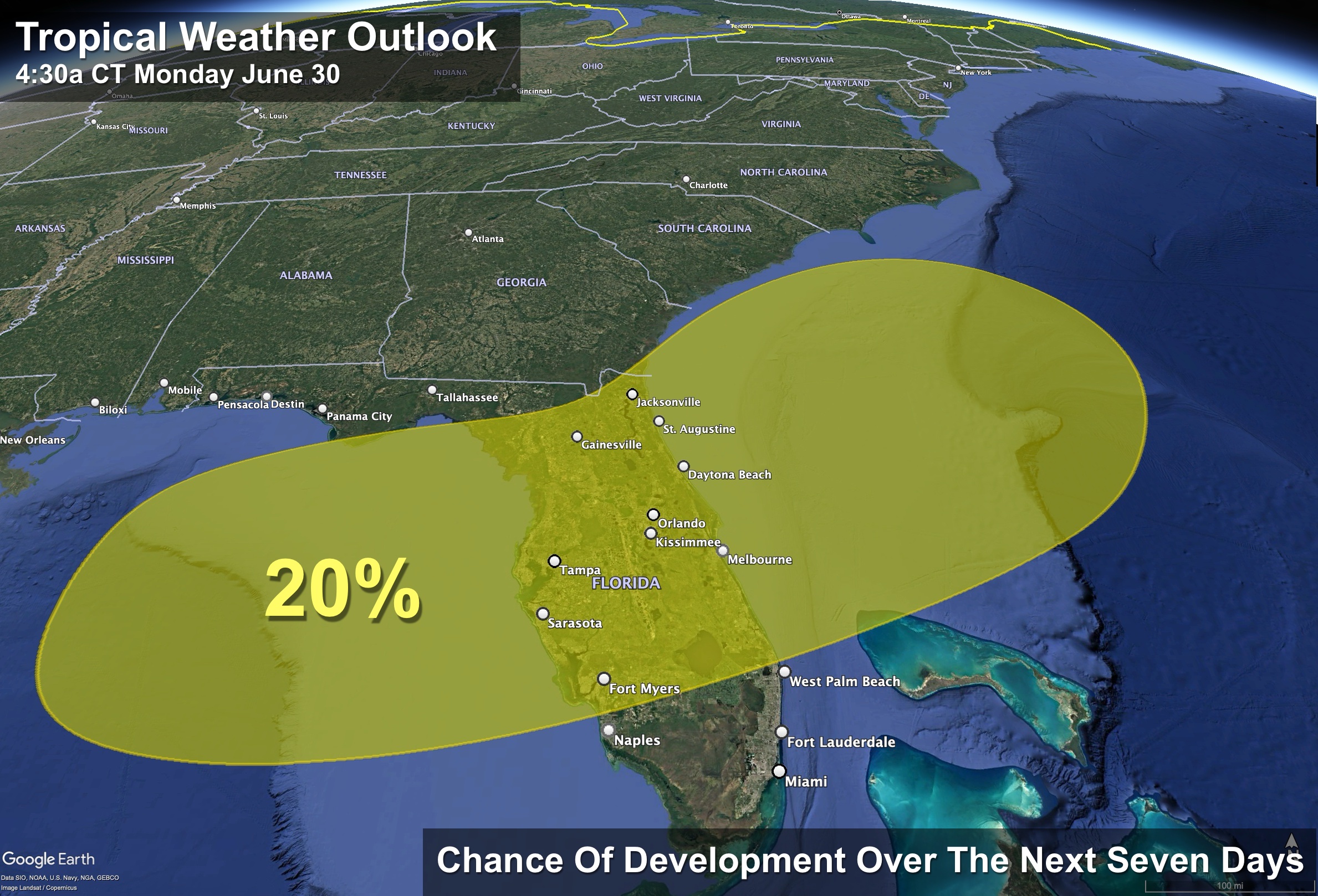
A frontal boundary is expected to stall and weaken off the southeast U.S. coast late this week. An area of low pressure could develop from the weakening front by next weekend off the southeast U.S., over Florida, or over the eastern Gulf. Some gradual tropical or subtropical development could occur thereafter as the low moves little. NHC gives it only a 20 percent chance of development; global models are not bullish on any development as well.
The rest of the Atlantic basin is very quiet.
ON THIS DATE IN 1912: An estimated F4 tornado ripped through Regina, Saskatchewan, Canada on this day. The storm became the deadliest tornado in Canada’s history as it killed 28 people along a rare, 18.5-mile track from south to north.
ON THIS DATE IN 2010: Hurricane Alex made its final landfall along the northern Mexican coast around 110 miles south of Brownsville, Texas as a Category 2 storm with maximum sustained winds of 105 mph. Alex was the first Hurricane in June for the Altantic Basin since 1995, and the strongest in the month of June since Hurricane Alma in 1966.
Look for the next video briefing here by 3:00 this afternoon… enjoy the day!
Category: Alabama's Weather, ALL POSTS, Weather Xtreme Videos
About the Author (Author Profile)
James Spann is one of the most recognized and trusted television meteorologists in the industry. He holds the AMS CCM designation and television seals from the AMS and NWA. He is a past winner of the Broadcast Meteorologist of the Year from both professional organizations.Subscribe
If you enjoyed this article, subscribe to receive more just like it.


